Road Maps of England and Wales
by John Ogilby 1675 - 1698
Richard Nicholson of Chester
A World of Antique Maps and Prints

Established in 1961
Plates 76 - 100

The maps on this page are guaranteed to be genuine early specimens published in or around the year stated
The following John Ogilby's Road Maps are currently in stock. They are all guaranteed to be genuine early specimens All in good clean condition and attractively hand coloured unless otherwise stated.
Also listed are some specimens of the original text for each road map that were only published in the first edition of Britannia
Plates 76 - 100
Each measuring about 17 x 13 inches
Published in 1675 and 1698

17th Century Road Map
-

King's Lynn, Gayton, Billingford, Norwich, Yarmouth John Oglby

29430 Plate 76. King's Lynn, Gayton, Billingford, Norwich, Yarmouth. Price: 125.00
An uncoloured specimen of the 1698 edition. Nice condition
Rare Ogilby Text - 1675

-

Plate 76 John Ogilby road map text 1675

28532 Plate 76. King's Lynn, Gayton, Billingford, Norwich, Yarmouth. Text only. Price: 30.00

The rare double sided page of folio text published in 1675 describing the route in great detail. A unique opportunity as it is very unlikely that I shall able to offer this again. Some water staining otherwise good
First Edition - 1675
-

Plate 76 King's Lynn to Norwich John Ogilby Road Map 1675

31834 Plate 76. The Road from King's Lynn to Norwich and Yarmouth. King's Lynn, Gayton, Billingford, Norwich, Yarmouth. Price: 190.00
The first edition of this 17th century strip road map. Embellished with a decorative title cartouche bearing the royal arms. 18 x 12 3/4 inches. Water stains in the bottom left and right hand blank margins otherwise good condition with wide blank margins. Uncoloured. Nice dark impression. Straight from the atlas so has never previously been sold as a single map
From: Britannia
TEXT The original double sided page of text from Britania to accompany this map is available to the purchaser at a reduced price of 25.00 if bought with the map.
First Edition - 1675
-

Plate 77 Monmouth to Llanbydder John Ogilby Road Map 1675

31835 Plate 77. The Road from Monmouth to Abergavenny, Crickhowell, Brecon to Llanybydder Price: 170.00
The first edition of this 17th century strip road map. Embellished with a decorative title cartouche showing goats and putti andbearing the royal arms. 16 1/2 x 13 inches. A very small area of paper thinning near the centre fold. Some light water staining on the edge of wide bottom blank margin. Otherwise good cnditin with nice wide blank margins. Uncoloured. Nice dark impression. Straight from the atlas so has never previously been sold as a single map. This is the second state with the plate number in the bottom right hand corner.
From: Britannia
TEXT The original double sided page of text from Britania to accompany this map is available to the purchaser at a reduced price of 25.00 if bought with the map.
17th Century - Framed
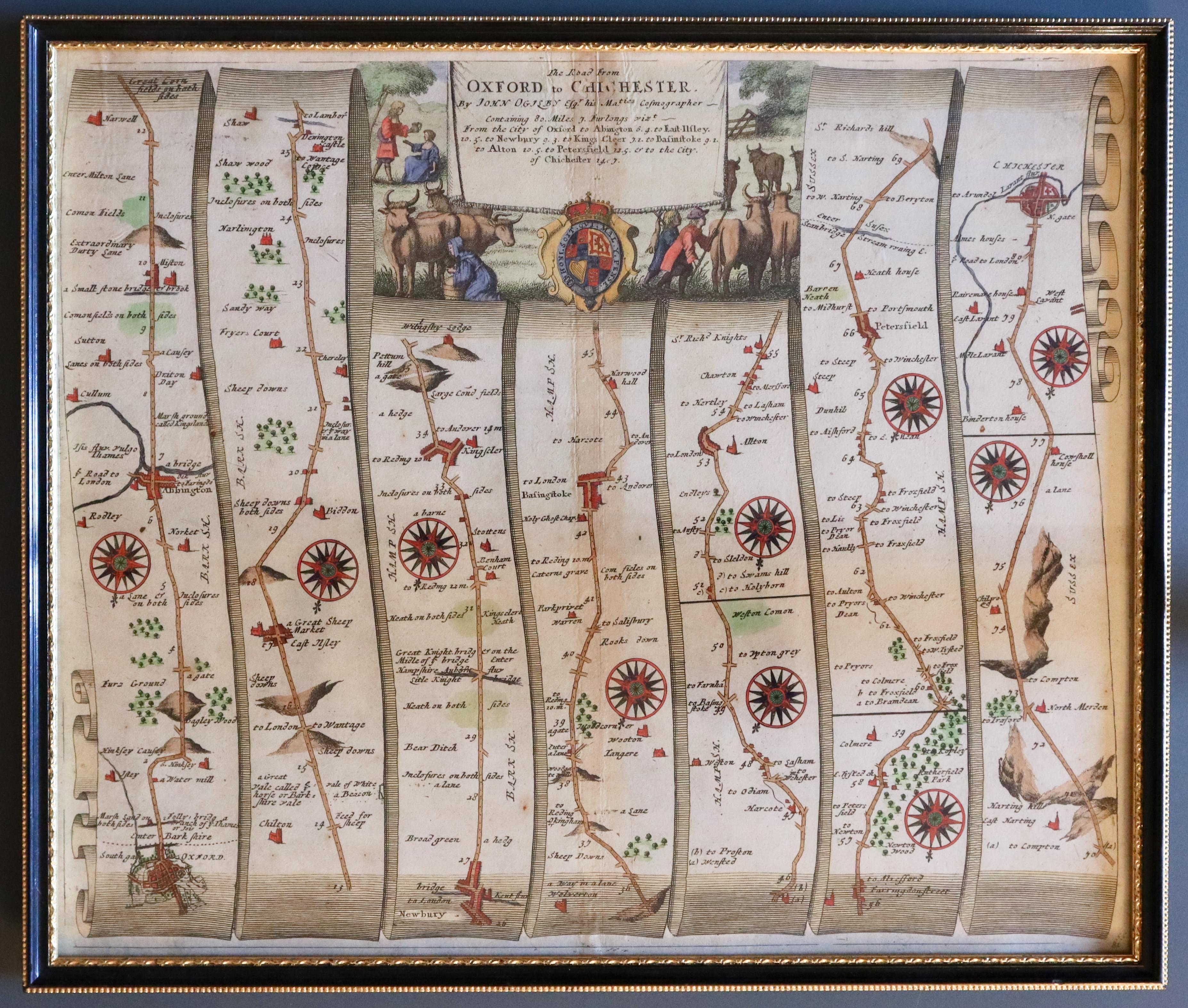
33421 Plate 81 The Road from Oxford to Chichester, 1698. Price: 140.00
Oxford, Abingdon, Newbury, Basingstoke, Peterfield, Chichester
A strip road map with a delightful title cartouche displaying a rural scene with cattle and people. Royal arms. 16 1/2 x 13 3/4 inches. Attractive hand colouring. Good condition. Framed many years ago in a black and gold hogarth moulding which is still in good condition.
I have not examined this map outside of the frame so it is sold as seen.
ONLY AVAILABLE BY COLLECTION FROM CHRISTLETON
Rare Ogilby Text - 1675
-

Plate 81 John Ogilby road map text 1675

31981 Plate 81. Oxford, Newbury, Basingstoke, Peterfield, Chichester. Text only. Price: 30.00
The rare double sided page of folio text published in 1675 describing the route in great detail. A unique opportunity as it is very unlikely that I shall able to offer this again. Some water staining otherwise good
First Edition - 1675
-

Plate 83 Oxford to Poole John Ogilby Road Map 1675
-

Plate 83 Oxford to Poole John Ogilby Road Map 1675

31841 Plate 83. The Road from Oxford, Great Shelford, Hungerford, North Tudworth, Salisbury, Cranborne, Wimborne, Poole. Price: 200.00
The first edition of this 17th century strip road map. Embellished with a decorative title cartouche showing goats and putti and bearing the royal arms. 16 1/2 x 13 inches. Some light water staining on the edge of the wide bottom blank margin. A little light discolouration at the top of the centre fold. Some slight worming at the bottom of the centre fold. You can view this on the close-up photo on the left. Otherwise the map is in nice condition with good blank margins. Uncoloured. Nice dark impression. Straight from the atlas so has never previously been sold as a single map
From: Britannia
TEXT The original double sided page of text from Britania to accompany this map is available to the purchaser at a reduced price of 25.00 if bought with the map.
First Edition - 1675
-

Plate 84 Presteigne to Carmarthen John Ogilby Road Map 1675

31842 Plate 84. The Road from Presteigne to Carmarthen. Price: 110.00
Presteigne, Builth Wells, Llandovery, Carmarthen
The first edition of this 17th century strip road map. Embellished with a decorative title cartouche bearing the royal arms. 17 x 12 1/4 inches. Original centre fold. Two small worm holes one each side of the centre fold in the wide bottom blank margin. Some old ink stains in the top blank margin above the title cartouche. A little light water staining on the edge f the bottom blank margin. Otherwise good clean undamaged condition. Uncoloured. Nice dark impression. Straight from the atlas so has never previously been sold as a single map
From: Britannia
TEXT The original double sided page of text from Britania to accompany this map is available to the purchaser at a reduced price of 25.00 if bought with the map.
First Edition - 1675
-

Plate 85 Salisbury to Chipping-Campden John Ogilby Road Map 1675

31843 Plate 85. The Road from Salisbury to Chipping Campden. Price: 210.00
Salisbury, Marlborough, Highworth, Lechlade, Burford, Stow-on-Wold, Chipping Campden
The first edition of this 17th century strip road map. Embellished with a decorative title cartouche bearing the royal arms, depicting a 17th century fox hunt with riders, hounds and the fox. 17 3/4 x 13 1/2 inches. Original centre fold. Two small worm holes one each side of the centre fold just in the printed area. Otherwise good clean undamaged condition. Uncoloured. Nice dark impression. Straight from the atlas so has never previously been sold as a single map
From: Britannia
TEXT The original double sided page of text from Britania to accompany this map is available to the purchaser at a reduced price of 25.00 if bought with the map.
17th Century Road Map
-

Ogilby Road Map York, Leeds, Rochdale, Manchester, Warrington 1698

31639 Plate 89. York, Leeds, Rochdale, Manchester, Warrington. Price: 110.00
1698 edition with plate number. Original centre fold. Light creases on the top left and right hand corners. Otherwise good condition with ample blank margins.
17th Century Road Map
-

Warrington, Chester. Manchester, Stockport, Derby John Ogilby

29437 Plate 90. Warrington, Chester. Manchester, Stockport, Derby. Price: 135.00
An uncoloured specimen of the 1698 edition. Small split at the bottom of the centre fold. Little light water staining in the left and right blank margins.
First Edition - 1675
-

Chelmsford, Sudbury, Bury St. Edmunds. Chelsford, Dunmow, Thaxted, Walden

10371 Plate 92. Chelmsford, Sudbury, Bury St. Edmunds. Chelsford, Dunmow, Thaxted, Walden. Price: 145.00
The 1675 edition with a plate number. Four matching small worm holes in the blank margins. A few scattered worm holes in the blank margins. Otherwise a nice clean crisp specimen. UNCOLOURED.
Rare Ogilby Text - 1675
-

Text for John Ogilby road map 92 published in 1675

28549 Plate 92. Chelmsford, Sudbury, Bury St. Edmunds. Price: 30.00
The rare double sided page of folio text published in 1675 describing the route in great detail. A unique opportunity as it is very unlikely that I shall able to offer this again. Some water staining otherwise good
17th Century Road Map
-

Chelmsford, Maldon / Rayleigh/Ingatestone, Billericay. Gravesend, Dover John Ogilby

29439 Plate 93. Chelmsford, Maldon / Rayleigh/Ingatestone, Billericay. Gravesend, Dover. Price: 115.00
An uncoloured specimen of the 1698 edition. Cannot really be seen but small printers crease on right hand side. Otherwise a nice specimen.
Rare Ogilby Text - 1675
The rare double sided page of folio text published in 1675 describing the route in great detail. A unique opportunity as it is very unlikely that I shall able to offer this again. Some water staining otherwise good
-

Text for John Ogilby road map 93 published in 1675

28671 Plate 93. Chelmsford, Maldon/Rayleigh/Ingatestone, Billericay. Gravesend, Dover. Price: 30.00
First Edition with Rare Text - 1675
-

Ferrybridge, Boroughbridge, Ripon, Barnard Castle. Ferrybridge, Wakefield
-

Text for Ogilby Plate 95 Ferrybridge, Boroughbridge, Ripon, Barnard Castle. Ferrybridge, Wakefield


25755 Plate 95. Ferrybridge, Boroughbridge, Ripon, Barnard Castle. Ferrybridge, Wakefield. Price: 220.00
No plate number and with the rare page of original text. Straight from the atlas formerly in the library of Robert George Windsor-Clive, Earl of Plymouth. UNCOLOURED. A few light brown spots in left and right margins.
First Edition - 1675
-

Plate 95 Ferrybridge to Barnard Castle John Ogilby 1675

31853 Plate 95. The Road from Ferrybridge to Boroughbridge continued to Barnard Castle. Ferrybridge, Ferrybridge, Ripon, Barnard Castle. Ferrybridge, Pontefract, Wakefield. Price: 180.00
The first edition of this 17th century strip road map. Embellished with a decorative title cartouche. 17 1/2 x 13 1/2 inches. Original centre fold. A nice specimen showing the 96 plate number. Three small worm holes either side of the centre fold just below the map in the blank margin. Light water stain in left and right blank margins. Uncoloured. Straight from the atlas so has never previously been sold as a single map.
From: Britannia
TEXT The original double sided page of text from Britania to accompany this map is available to the purchaser at a reduced price of 25.00 if bought with the map.
Rare Ogilby Text - 1675
The rare double sided page of folio text published in 1675 describing the route in great detail. A unique opportunity as it is very unlikely that I shall able to offer this again. Some water staining otherwise good
-
Text for John Ogilby road map 93 published in 1675
25673 Plate 95. Ferrybridge, Boroughbridge, Ripon, Barnard Castle. Ferrybridge, Wakefield. Text only. Price: 30.00
First Edition - 1675
-

Plate 96 Kendal to Cockermouth and Carlisle, John Ogilby 1675

31854 Plate 96. The Road from Kendal to Cockermouth. The Road from Egremont to Carlisle. Kendal, Ambleside, Cockermouth. Egremont, Cleator, Cockermouth, Thursby, Carlisle. Price: 180.00
The first edition of this 17th century strip road map. Embellished with a decorative title cartouche. 17 1/2 x 13 1/2 inches. Original centre fold. A nice specimen showing the 96 plate number. Three small worm holes either side of the centre fold just below the map in the blank margin. Light water stain in left and right blank margins. Uncoloured. Straight from the atlas so has never previously been sold as a single map.
From: Britannia
TEXT The original double sided page of text from Britania to accompany this map is available to the purchaser at a reduced price of 25.00 if bought with the map.
First Edition with Rare Text - 1675
-

Alresford, Winchester, Poole, Christchurch. Southampton, Winchester John Ogiby

25757 Plate 97. The Road from London to Poole. Alresford, Winchester, Rumsey Ringwood, Poole. Poole, Christchurch, Lymington, Southampton, Winchester.. Price: 195.00
The first edition of this 17th century strip road map. Embellished with a decorative title cartouche. 17 1/2 x 13 1/4 inches. Original centre fold. A nice specimen of this first edition showing no plate number. Uncoloured. Straight from the atlas so has never previously been sold as a single map. With the map is the original double sided page of descriptive text.
From: Britannia
First Edition - 1675
-

Plate 97 London to Poole John Ogilby 1675

31855 Plate 97. The Road from London to Poole. Alresford, Winchester, Rumsey Ringwood, Poole. Poole, Christchurch, Lymington, Southampton, Winchester. Price: 200.00
The first edition of this 17th century strip road map. Embellished with a decorative title cartouche. 17 1/2 x 13 1/4 inches. Original centre fold. A nice specimen showing the 97 plate number. Three small worm holes either side of the centre fold just below the map in the blank margin. Uncoloured. Straight from the atlas so has never previously been sold as a single map.
From: Britannia
TEXT The original double sided page of text from Britania to accompany this map is available to the purchaser at a reduced price of 25.00 if bought with the map.
17th Century Road Map
-

Shrewsbury, Wrexham, Holywell, Chester, Flint. Holywell John Ogilby

29443 Plate 98. Shrewsbury, Wrexham, Holywell, Chester, Flint. Holywell. Price: 115.00
An uncoloured specimen of the 1698 edition. Top left hand blank margin corner missing. Lightly toned.
Rare Ogilby Text - 1675
-

Text plate 98 John Ogilby Road map 1675

28555 Plate 98. Shrewsbury, Wrexham, Holywell, Chester, Flint. Holywell. Text only. Price: 30.00
The rare double sided page of folio text published in 1675 describing the route in great detail. A unique opportunity as it is very unlikely that I shall able to offer this again. Some water staining otherwise good
First Edition - Rare Text Available - 1675
-

Road from Whitby to Durham and Tynemouth, John Ogilby 1675

31857 Plate 99. The Road from Whitby to Durham. Whitby, Guisborough, Durham, Tynemouth. Price: 180.00
The first edition of this 17th century strip road map. Embellished with a decorative title cartouche. 17 3/4 x 13 1/4 inches. Original centre fold. Small v shaped worm hole in the bottom blank margin repaired otherwise the map is in nice clean You can view this on the close-up photo on the left. Otherwise the map is in nice clean undamaged condition with good blank margins. Uncoloured. Straight from the atlas so has never previously been sold as a single map
From: Britannia
TEXT
The original double sided page of text from Britania to accompany this map is available to the purchaser at a reduced price of 25.00 if bought with the map. Evidence of the worm hole mentioned n the description of the map is there with a small tear on the edge of the bottom blank margin.
17th Century Road Map
-

Road map Whitby to Tynemouth, John Ogilby 1698

33342 Plate 99 Whitby, Guisborough, Stockton, Durham, Sunderland, Tynemouth. Price: 38.00
An uncoloured specimen of the 1698 edition. Not in the usual fine condition that I like to be able to offer Ogilby road maps. Original centre fold. Small slit at the bottom of the centre fold. Bottom blank margin tapers with a small amount in the bottom right hand corner. Nick in left hand blank margin and some repairs to the bottom margin. Some vertical creasing. Map lightly toned
RICHARD NICHOLSON
of CHESTER
Stoneydale
Pepper Street
Christleton
Chester
CH3 7AG
Telephone
01244 336004
International 44 1244 336004

I have been buying and selling antique maps since the early 1960's during which time I had a gallery in Watergate Street, Chester for 30 years. I am now able to offer through my websites a personal service to map and print collectors.

