Road Maps of England and Wales
by John Ogilby 1675 - 1698
Richard Nicholson of Chester
A World of Antique Maps and Prints

Established in 1961
Plates 51 - 75

The maps on this page are guaranteed to be genuine early specimens published in or around the year stated
The following John Ogilby's Road Maps are currently in stock. They are all guaranteed to be genuine early specimens All in good clean condition and attractively hand coloured unless otherwise stated.
Also listed are some specimens of the original text for each road map that were only published in the first edition of Britannia
Plates 51 - 75
Each measuring about 17 x 13 inches
Published in 1675 and 1698

17th Century Road Map
-

London to Southampton. Bagshot, Farnham, Alton, Alresford, Southampton, Romsey, Salisbury

29416 Plate 51. The Road from London to Southampton. Bagshot, Farnham, Alton, Alresford, Southampton, Romsey, Salisbury. Price: 115.00
An uncoloured specimen of the 1698 edition. No left and right hand blank margins with some slight trimming. I have seen this before with this plate as it is slightly larger than other road maps in the Britannia.
First Edition - 1675

-

Plate 27 John Ogilby Road Map 1675

31808 Plate 51. The Road from London to Southampton. Bagshot, Farnham, Alton, Alresford, Southampton, Romsey, Salisbury. Price: 280.00
The first edition of this 17th century strip road map. Embellished with a decorative title cartouche with putti and the royal arms. 16 1/4 x 13 1/4 inches. Good condition with wide blank margins. Uncoloured. Nice dark impression. Straight from the atlas so has never previously been sold as a single map
From Britannia
TEXT The original double sided page of text from Britania to accompany this map is available to the purchaser at a reduced price of 25.00 if bought with the map.
Rare Ogilby Text
-

Text Plate 51 John Ogily Road Map 1675

28629 Plate 51. The Road from London to Southampton. Bagshot, Farnham, Alton, Alresford, Southampton, Romsey, Salisbury. Text only. Price: 30.00

The rare double sided page of folio text published in 1675 describing the route in great detail. A unique opportunity as it is very unlikely that I shall able to offer this again. Some water staining otherwise good
First Edition - 1675
-

Plate 51 Bagshot to Salisbury John Ogilby Road Map 1675

31808 Plate 51. The Road from London to Southampton. Bagshot, Farnham, Alton, Alresford, Southampton, Romsey, Salisbury. Price: 280.00
The first edition of this 17th century strip road map. Embellished with a decorative title cartouche with putti and the royal arms. 16 1/4 x 13 1/4 inches. Good condition with wide blank margins. Uncoloured. Nice dark impression. Straight from the atlas so has never previously been sold as a single map
From: Britannia
TEXT The original double sided page of text from Britania to accompany this map is available to the purchaser at a reduced price of 25.00 if bought with the map.
First Edition - 1675
-

Newmarket, Swaffham, Wells, Newmarket, Bury St. Edmunds John Ogilby

25712 Plate 52. Newmarket, Swaffham, Wells, Newmarket, Bury St. Edmunds. Price: 200.00
1675 edition with no plate number and with the rare page of original text. Straight from the atlas formerly in the library of Robert George Windsor-Clive, Earl of Plymouth. UNCOLOURED
First Edition - 1675
-

Plate 52 Newmarket to Bury St. Edmunds John Ogilby Road Map 1675

31810 Plate 52. The Road from London to Wells. Newmarket, Swaffham, Wells, Newmarket, Bury St. Edmunds. Price: 190.00
The first edition of this 17th century strip road map. Embellished with a decorative pictorial title cartouche with shepherd, sheperdess and sheep. Plus the royal arms. 17 1/4 x 12 3/4 inches. Small piece missing from the top of the top left hand blank margin otherwise good condition with wide blank margins. Uncoloured. Nice dark impression. Straight from the atlas so has never previously been sold as a single map
From Britannia
TEXT The original double sided page of text from Britania to accompany this map is available to the purchaser at a reduced price of 25.00 if bought with the map.
Rare Ogilby Text - 1675
-

Text Plate 52 John Ogily Road Map 1675

28508 Plate 52. Newmarket, Swaffham, Wells, Newmarket, Bury St. Edmunds. Text only. Price: 30.00
The rare double sided page of folio text published in 1675 describing the route in great detail. A unique opportunity as it is very unlikely that I shall able to offer this again. Some water staining otherwise good
Rare Ogilby Text - 1675
-

Text Plate 52 John Ogily Road Map 1675

28630 Plate 52. Newmarket, Swaffham, Wells, Newmarket, Bury St. Edmunds. Text only. Price: 30.00
The rare double sided page of folio text published in 1675 describing the route in great detail. A rare opportunity as it is very unlikely that I shall able to offer this again.
First Edition - 1675
-

Plate 53 London to Weymouth John Ogilby Road Map 1675

31811 Plate 53. The Road from London to Weymouth. Basingstoke, Stockbridge, Cranborne, Blandford, Dorchester, Weymouth. Price: 180.00
The first edition of this 17th century strip road map. Embellished with a decorative title cartouche with the royal arms. 18 1/4 x 13 1/2 inches. Some light water stains in the bottom left and right hand bottom blank margins. Otherwise good condition with wide blank margins. Uncoloured. Nice dark impression. Straight from the atlas so has never previously been sold as a single map
From: Britannia
TEXT The original double sided page of text from Britania to accompany this map is available to the purchaser at a reduced price of 25.00 if bought with the map.
First Edition - 1675
-

Plate 54 London to Yarmouth John Ogilby Road Map 1675


31812 Plate 54. The Road from London to Yarmouth. Colchester, Ipswich, Saxmundham, Beccles, Yarmouth. Price: 195.00
The first edition of this 17th century strip road map. Embellished with a decorative title cartouche with the royal arms. 17 1/2 x 13 1/2 inches. Good condition with wide blank margins. Uncoloured. Nice dark impression. Straight from the atlas so has never previously been sold as a single map
Fromm Britannia
TEXT The original double sided page of text from Britania to accompany this map is available to the purchaser at a reduced price of 25.00 if bought with the map.
Bristol to Banbury
-

Road from Bristol to Banbury, John Oglby 1698

31813 Plate 55. The Road from Bristol to Banbury. Bristol, Chipping Sodbury, Tetbury, Cirencester, Burford, Banbury. Price: 118.00
An engraved 17th century strip road map. Embellished with a decorative title cartouche with the royal arms. 17 1/4 x 13 inches. Nice clear watermark. Uncoloured. Small rust spot and second small rust spot with professional repair. A few small foxing spots and a little light creasing but otherwise good condition.
From: Britannia
Rare Ogilby Text - 1675
-

Text Plate 53 John Ogily Road Map 1675

28512 Plate 56. Bristol, Chepstow, Monmouth, Hereford, Leominster, Ludlow. Text only. Price: 22.00
The rare double sided page of folio text published in 1675 describing the route in great detail. A rare opportunity as it is very unlikely that I shall able to offer this again.
Rare Ogilby Text
-

Plate 58 Bristol to Exeter John Ogilby Text 1675

28636 Plate 58. The Road from Bristol to Exeter. Bristol, Wells, Glastonbury, Taunton, Exeter. Price: 20.00
The rare double sided page of folio text published in 1675 describing the route in great detail. A unique opportunity as it is very unlikely that I shall able to offer this again. Some water staining otherwise good
First Edition - 1675
-

Plate 59 Bristol to Worcester John Ogilby Road Map 1675

31817 Plate 59. The Road from Bristol to Worcester. Bristol, Gloucester, Tewksbury, Worcester. Price: 220.00
The first edition of this 17th century strip road map. Embellished with a decorative title cartouche. 17 1/2 x 13 1/2 inches. Good condition with wide blank margins. Uncoloured. Nice dark impression. Straight from the atlas so has never previously been sold as a single map
From: Britannia
TEXT The original double sided page of text from Britania to accompany this map is available to the purchaser at a reduced price of 25.00 if bought with the map.
First Edition - 1675
-

Plate 60 Bristol to Weymouth John Ogilby Road Map 1675

31818 Plate 60. The Road from Bristol to Weymouth. Bristol, Wells, Glastonbury, Somerton, Mattock, Crewkerne, South Perrott, Frampton, Weymouth. Price: 52.00.
A 17th century strip road map. Embellished with a decorative title cartouche bearing the roayl arms. 17 x 13 1/4 inches. This map has suffered some damage but been rebacked before been rebound back into the atlas. As you will see from the illustration there is some loss of the blank margin across the bottom and on the right hand side. Single tear on right hand side extending 2 inches into the engraved area. On the right hand side there are some tears just extending in to the prints area. Rebacked with a much later thicker paper. Uncoloured. Nice dark impression. Straight from the atlas so has never previously been sold as a single map. Special price.
From: Britannia
TEXT The original double sided page of text from Britania to accompany this map is available to the purchaser at a reduced price of 25.00 if bought with the map.
First Edition - 1675
-

Plate 61 Cambridge to Coventry John Ogilby Road Map 1675

31819 Plate 61. The Road from Cambridge to Coventry. Cambridge, St. Neots, Northampton, Rugby, Coventry. Price: 280.00
The first edition of this 17th century strip road map. Embellished with a decorative title cartouche showing a stag hunting scene and bearing the royal arms. 16 1/2 x 13 3/4 inches. Good condition with wide blank margins. Uncoloured. Nice dark impression. Straight from the atlas so has never previously been sold as a single map
From: Britannia
TEXT The original double sided page of text from Britania to accompany this map is available to the purchaser at a reduced price of 25.00 if bought with the map.
17th Century Road Map
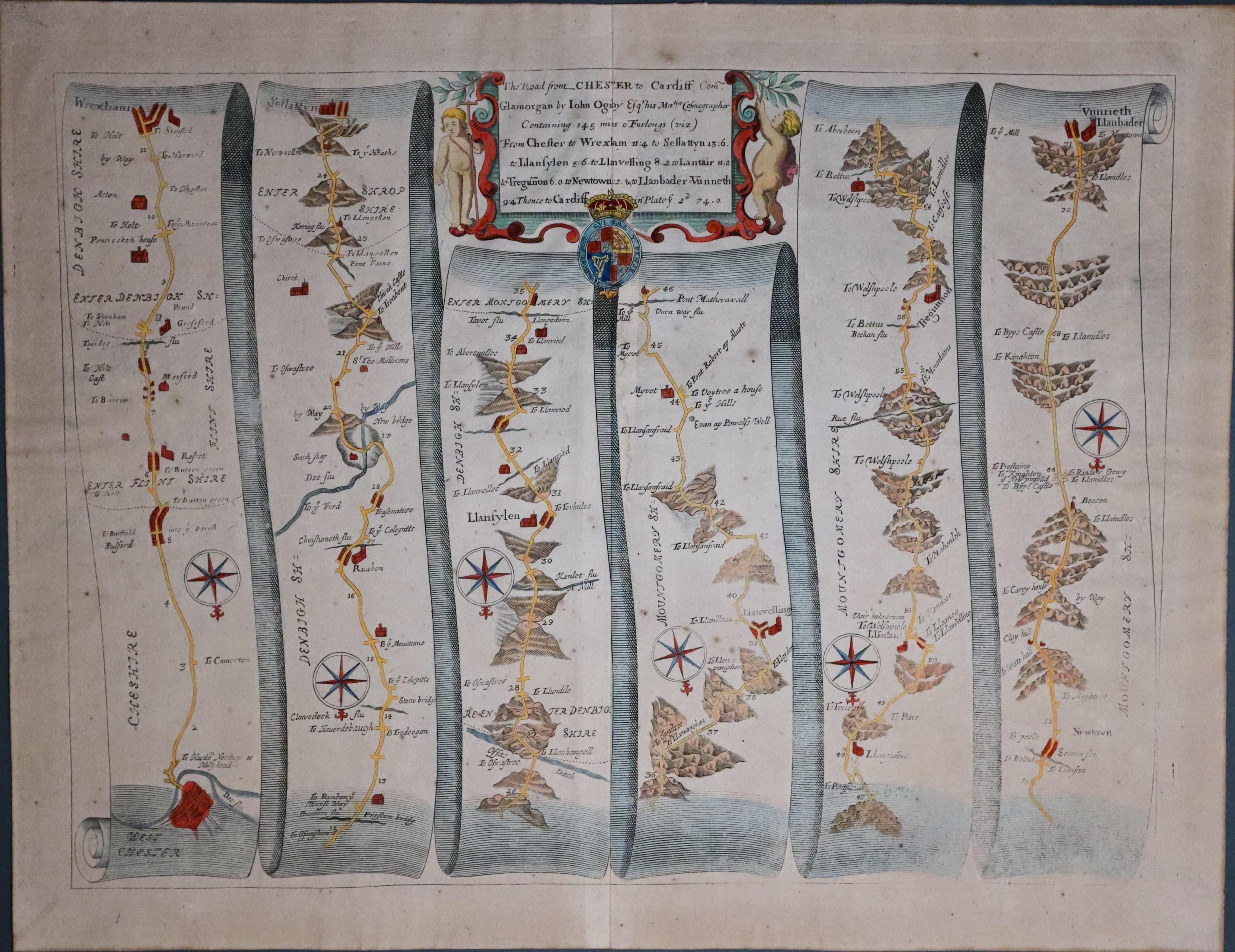
33560 Plate 63. The Road from Chester to Cardiff. Chester, Marfordm, Wrexham, Ruabon, Newtown, Llanbader. Price: 120.00
The 1698 edition of this 17th century strip road map embellished with a decorative title cartouche with putti bearing the royal arms. 16 3/4 x 12 1/4 inches. Original centre fold Otherwise good condition with wide blank margins. Hand coloured. Lightly toned. God condition.
From: Britannia
Rare Ogilby Text
-

Bristol to Weymouth Text, John Ogilby 1675

28641 Plate 63. Chester, Wrexham Newtown, Llanbader. Text only. Price: 30.00
The rare double sided page of folio text published in 1675 describing the route in great detail. A unique opportunity as it is very unlikely that I shall able to offer this again. Some water staining otherwise good
First Edition - 1675
-

Plate 64 Chester to Cardiff John Ogilby Road Map 1675

31822 Plate 64. The Road from Chester to Cardiff. Llanbadardfynydd, Brecon, Cardiff. Price: 148.00
The first edition of this 17th century strip road map. Embellished with a decorative title cartouche. 17 1/4 x 13 1/4 inches. Two matching water stain in the left and right hand bottom blank margins. Otherwise good condition with wide blank margins. Uncoloured. Nice dark impression. Straight from the atlas so has never previously been sold as a single map
From: Britannia
TEXT The original double sided page of text from Britania to accompany this map is available to the purchaser at a reduced price of 25.00 if bought with the map.
First Edition
-

Ogilby map Llanbadern Fynynydd to Cardiff 1675

33658 Plate 64. Llanbaddern Fynydd to Cardiff, 1675. Price: 148.00
The Continuation of the Road from Chester to Cardiff
The first edition of this 17th century strip road map. It shows no plate number. The route starts at Llanbadarn Fynydd and continues on through Brecon to Cardiff. Embellished with a decorative title cartouche bearing the royal arms. 17 1/4 x 13 1/4 inches. Original centre fold. Attractive hand colouring. Good clean condition.
From: Britannia
This map was sold by me back in the 1960’s and has now come back into stock
First Edition - 1675
-

Plate 65 Darmouth toMinehead John Ogilby Road Map 1675

31823 Plate 65. The Road from Dartmouth to Minehead. Dartmouth, Exeter, Tiverton, Minehead. Price: 220.00
The first edition of this 17th century strip road map. Embellished with a decorative title cartouche bearing the royal arms. 17 1/4 x 13 1/4 inches. Good condition with wide blank margins. Uncoloured. Nice dark impression. Straight from the atlas so has never previously been sold as a single map
From: Britannia
TEXT The original double sided page of text from Britania to accompany this map is available to the purchaser at a reduced price of 25.00 if bought with the map.
First Edition - 1675
-

Plate 66 Chester to Cardiff John Ogilby Road Map 1675

31824 Plate 66. The Road from St. David's to Pembroke. St. Davids, Fishguard, Cardigan, Talybont. Price: 190.00
The first edition of this 17th century strip road map. Embellished with a decorative title cartouche bearing the royal arms. 17 1/2 x 14 inches. Tiny piece missing on the endge of the left hand bottom blank margin. Otherwise good condition with wide blank margins. Uncoloured. Nice dark impression. Straight from the atlas so has never previously been sold as a single map
From: Britannia
TEXT The original double sided page of text from Britania to accompany this map is available to the purchaser at a reduced price of 25.00 if bought with the map.
First Edition - 1675
-

Talybont, Bala, Ruthin, Holywell John Ogilby

29283 Plate 67. Talybont, Bala, Ruthin, Holywell. Price: 95.00
1675 edtion with no plate number. An area of the map which has not been covered by a mount when framed is now lightly toned with some very light foxing.
First Edition - 1675
-

Plate 67 Talybont to Holywell John Ogilby Road Map 1675

31825 Plate 67. Continuation ot the Road from St. David's to Pembroke. Talybont, Bala, Ruthin, Holywell. Price: 160.00
The first edition of this 17th century strip road map. Embellished with a decorative title cartouche. 17 3/4 x 13 3/4 inches. Two matching water stain in the bottom left and right hand blank margins. Otherwise good condition with wide blank margins. Uncoloured. Nice dark impression. Straight from the atlas so has never previously been sold as a single map
From: Britannia
TEXT The original double sided page of text from Britania to accompany this map is available to the purchaser at a reduced price of 25.00 if bought with the map.
Rare Ogilby Text
-

Text Talybont, Bala, Ruthin, Holywell John Ogilby road map 1675

28645 Plate 67. Talybont, Bala, Ruthin, Holywell. Text only. Price: 20.00
The rare double sided page of folio text published in 1675 describing the route in great detail. A unique opportunity as it is very unlikely that I shall able to offer this again. Some water staining otherwise good
First Edition - 1675
-

Plate 68 Exeter to Barstaple John Ogilby Road Map 1675

31826 Plate 68. The Road from Exeter to Barnstaple. Exeter, Chumleigh, Ilfracombe, Bideford, Torrington. Price: 220.00
The first edition of this 17th century strip road map. Embellished with a decorative title cartouche. 17 x 12 3/4 inches. Good condition with wide blank margins. Uncoloured. Nice dark impression. Straight from the atlas so has never previously been sold as a single map
From: Britannia
TEXT The original double sided page of text from Britania to accompany this map is available to the purchaser at a reduced price of 25.00 if bought with the map.
Rare Ogilby Text
-

Text for Plate 68 John Ogilby road map 1675

28524 Plate 68. Exeter, Chumleigh, Ilfracombe, Bideford, Torrington. Text only. Price: 20.00
The rare double sided page of folio text published in 1675 describing the route in great detail. A unique opportunity as it is very unlikely that I shall able to offer this again. Some water staining otherwise good
17th Century Road Map
-

Gloucester, Cheltenham, Chipping Campden, Warwick, Coventry John Oglby

31483 Plate 70. Gloucester, Cheltenham, Chipping Campden, Warwick, Coventry. Price: 75.00
A few worm holes near the centre fold in the top and bottom blank margins. This map has been in a sunk mount and framed for 30 years or more. There are traces of the masking tape used to hold in in the mount on the edges of all four edges and across each corner. Hand coloured. Lightly toned.
First Edition - 1675
-

Plate 70 Gloucester to Coventry John Ogilby Road Map 1675

31828 Plate 70. The Road from Gloucester to Coventry. Gloucester, Cheltenham, Chipping Campden, Warwick, Coventry. Price: 220.00
The first edition of this 17th century strip road map. Embellished with a decorative title cartouche bearing the royal arms. 17 x 12 1/8 inches. Good condition with wide blank margins. Uncoloured. Nice dark impression. Straight from the atlas so has never previously been sold as a single map
From: Britannia
TEXT The original double sided page of text from Britania to accompany this map is available to the purchaser at a reduced price of 25.00 if bought with the map.
Rare Ogilby Text
-

Text for Plate 71 by John Ogilby 1675

28649 Plate 71. Gloucester, Ross-on-Wye, Hereford, Knighton, Montgomery. Text only. Price: 30.00
The rare double sided page of folio text published in 1675 describing the route in great detail. A unique opportunity as it is very unlikely that I shall able to offer this again. Some water staining otherwise good
First Edition - 1675
-

Plate 71 Gloucester to Montgomery John Ogilby Road Map 1675

31829 Plate 71. The Road from Gloucester to Montgomery. Gloucester, Ross-on-Wye, Hereford, Knighton, Montgomery. Price: 220.00
The first edition of this 17th century strip road map. Embellished with a decorative title cartouche bearing the royal arms. 17 1/4 x 12 1/2 inches. Good condition with wide blank margins. Uncoloured. Nice dark impression. Straight from the atlas so has never previously been sold as a single map
From: Britannia
TEXT The original double sided page of text from Britania to accompany this map is available to the purchaser at a reduced price of 25.00 if bought with the map.
The purchase of this map can be by direct payment to my bank account. Or by telephoning me with your credit/debit card details. Please telephone me first to check the map is available - 01244 336004. If paying to my bank please email me afterwards advising and giving me your name and address as to where the map is to be sent.
First Edition - 1675
-

Plate 72 Hereford to Leicester John Ogilby Road Map 1675

31830 Plate 72. The Road from Hereford to Leicester. Hereford, Worcester, Droitwich, Bromsgrove, Coventry, Leicester. Price: 220.00
The first edition of this 17th century strip road map. Embellished with a decorative title cartouche bearing the royal arms. 17 1/2 x 13 1/2 inches. Good condition with wide blank margins. Uncoloured. Nice dark impression. Straight from the atlas so has never previously been sold as a single map
From: Britannia
TEXT The original double sided page of text from Britania to accompany this map is available to the purchaser at a reduced price of 25.00 if bought with the map.
17th Century Road Map
-

Hereford, Worcester, Droitwich, Bromsgrove, Coventry, Leicester John Pgilby

29426 Plate 72. Hereford, Worcester, Droitwich, Bromsgrove, Coventry, Leicester. Price: 115.00
An uncoloured specimen of the 1698 edition. Slight crease in the paper to the right of the centre fold when the map was printed. Otherwise a nice specimen
First Edition - 1675
-

Plate 73 Huntingdon to Ipswich John Ogilby Road Map 1675

31831 Plate 73. The Road from Huntingdon to Ipswich. Huntingon, Ely, Bury St. Edmunds. Price: 200.00
The first edition of this 17th century strip road map. Embellished with a decorative title cartouche bearing the royal arms. 18 x 12 3/4 inches. Matching water stain in the bottom left and right hand blank margins otherwise good condition with wide blank margins. Uncoloured. Nice dark impression. Straight from the atlas so has never previously been sold as a single map
From: Britannia
TEXT The original double sided page of text from Britania to accompany this map is available to the purchaser at a reduced price of 25.00 if bought with the map.
Rare Ogilby Text
-

King's Lynn, Thetford, Stowmarket, Harwich John Ogilby

28652 Plate 74. Ipswich, Thwaite, Norwich, Cromer. Text Only. Price: 30.00
The rare double sided page of folio text published in 1675 describing the route in great detail. A unique opportunity as it is very unlikely that I shall able to offer this again. Some light water staining otherwise good
17th Century Road Map
-

King's Lynn, Thetford, Stowmarket, Harwich John Ogilby

29429 Plate 75. King's Lynn, Thetford, Stowmarket, Harwich. Price: 120.00
An uncoloured specimen of the 1698 edition. Light rust spot otherwise good condition.
Rare Ogilby Text
-

Text for Ogilby Road Map 75 published in 1675

28653 Plate 75. King's Lynn, Thetford, Stowmarket, Harwich. Text only. Price: 30.00
The rare double sided page of folio text published in 1675 describing the route in great detail. Some light water staining. A unique opportunity as it is very unlikely that I shall able to offer this again.
Rare Ogilby Text
28653 Plate 75. King's Lynn, Thetford, Stowmarket, Harwich. Text only. Price: 30.00
The rare double sided page of folio text published in 1675 describing the route in great detail. A unique opportunity as it is very unlikely that I shall able to offer this again.
17th Century Road Map
-

Plate 75 King's Lynn to Harwich John Ogilby Road Map 1675

25735 Plate 75. The Road from Ipswich to Norwich. King's Lynn, Thetford, Stowmarket, Harwich. Price: 185.00
The first edition of this 17th century strip road map. No plate number. Good condition with wide blank margins. Uncoloured. Nice dark impression. Straight from the atlas formerly in the library of Robert George Windsor-Clive, Earl of Plymouth. With this map is the original double sided page of text ddescribing the route.
From: Britannia
TEXT The original double sided page of text from Britania to accompany this map is available to the purchaser at a reduced price of 25.00 if bought with the map.
17th Century Road Map
-

Plate 75 King's Lynn to Harwich John Ogilby Road Map 1675

31833 Plate 75. The Road from Ipswich to Norwich. King's Lynn, Thetford, Stowmarket, Harwich. Price: 190.00
The first edition of this 17th century strip road map. Embellished with a decorative title cartouche bearing the royal arms. 18 x 12 3/4 inches. Light water stain in the bottom right hand blank margin otherwise good condition with wide blank margins. Uncoloured. Nice dark impression. Straight from the atlas so has never previously been sold as a single map
From: Britannia
TEXT The original double sided page of text from Britania to accompany this map is available to the purchaser at a reduced price of 25.00 if bought with the map.
The purchase of this map can be by direct payment to my bank account. Or by telephoning me with your credit/debit card details. Please telephone me first to check the map is available - 01244 336004. If paying to my bank please email me afterwards advising and giving me your name and address as to where the map is to be sent.
RICHARD NICHOLSON
of CHESTER
Stoneydale
Pepper Street
Christleton
Chester
CH3 7AG
Telephone
01244 336004
International 44 1244 336004

I have been buying and selling antique maps since the early 1960's during which time I had a gallery in Watergate Street, Chester for 30 years. I am now able to offer through my websites a personal service to map and print collectors.

