Antique Maps of
Languedoc and Lorraine
Richard Nicholson of Chester

Established in 1961
A World of Antique Maps and Prints

The maps on this page are guaranteed to be genuine early specimens published in or around the year stated
LANGUEDOC
18th Century - Town Plan
-

Narbonne, J. N. Bellin, 1764

8137 Narbonne, J. N. Bellin, 1764. Price: 45.00
PLAN DE NARBONE
A simple town plan with rococo cartouche. Compass rose. 6 x 9 inches, 165 x 220 mm. Some original blue outline hand colouring. Good condition.
From: Le Petit Atlas Maritime
18th Century - Sea Chart
-

Montpelier, J. N. Bellin, 1764

23842 Montpelier, J. N. Bellin, 1764. Price: 55.00
COSTE DE LANGUEOC DEPUIS CETTE JUSQU'A L'ETANG DE REPOUSSET
An engraved chart showing part of the Languedoc coast with the town of Montpelier in the centre. Uncoloured rococo cartouche. 14 1/2 x 8 1/2 inches. Original blue outline and wash colouring. Good condition.
From: Le Petit Atlas Maritime
18th Century Sea Chart - Early Hand Colouring
-

Camargue, Jacques Nicolas Bellin, 1764
23843 Camargue, Jacques Nicolas Bellin, 1764. Price: 49.00
ENVIRONS D'AIGUEMORTES DE PECCAIS &A ET LA PETITE CAMARGUE
An engraved chart of the Camargue coast around Aigues-Mortes and Peccais. Uncoloured rococo cartouche. 7 x 8 1/2 inches. Original blue outline and wash colouring. Good condition.
From: Le Petit Atlas Maritime
18th Century Town Plan - Early Hand Colouring
-

Aigues-Mortes, Jacques Nicolas Bellin, 1764

23844 Aigues-Mortes, Jacques Nicolas Bellin, 1764. Price: 42.00
PLAN D'AIGUESMORTES ET ENVIRONS
A simple engraved plan of Aigues-Mortes. Uncoloured rococo title cartouche. 6 1/2 x 9 inches. Original blue outline and wash colouring. Good condition.
From: Le Petit Atlas Maritime
18th Century Sea Chart - Early Hand Colouring
-

Sete, Jacques Nicholas Bellin, 1764

23845 Sete, Jacques Nicholas Bellin, 1764. Price: 48.00
PORT DE CETTE ET ENTREE DU CANAL DE LANGUEDOC
An engraved chart of Sete showing the entrance to the Canal. Uncoloured rococo cartouche displaying the title and scale. Original blue outline and wash colouring. Good condition.
From: Le Petit Atlas Maritime
18th Century Sea Chart - Early Hand Colouring
-

Agde, Jacques Nicholas Bellin, 1764

23846 Agde, Jacques Nicholas Bellin, 1764. Price: 48.00
PLAN DU PORT ET VILLE D'AGDE A LA COST DE LANGUEDOC
An engraved chart showing part of the Languedoc coast and the town of Agde. Uncoloured rococo cartouche. 11 3/4 x 8 3/4 inches. Original blue outline and wash colouring. Good condition.
From: Le Petit Atlas Maritime
18th Century - Sea Chart
-

Languedoc Coast, Joseph Roux, 1764

27869 Languedoc Coast, Joseph Roux, 1764. Price: 49.00
LANGUEDOC
A small engraved chart showing tpart of the coast line with Etang de St. Martin. Depth sounding and anchorage point shown. 7 1/2 x 5 inches. Uncoloured. Good condition.
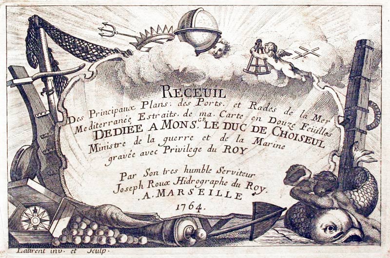
Plate 17 Receuil Des Principaux Plans; des Ports, et Rades de la Mer Mediterranée, Estraits, de ma. Carte Douze Feüilles.... Marselle 1764
18th Century Sea Chart - Early Hand Colouring
-

Cette, Joseph Roux, 1764
27870 Cette, Joseph Roux, 1764. Price: 52.00
CETTE
A small engraved chart showing the entrance to the harbour with the town. Depth soundings and anchorage points are shown. Compass pointer and scale. 7 1/2 x 5 inches. Uncoloured. Good condition.
Plate 18 From Receuil Des Principaux Plans; des Ports, et Rades de la Mer Mediterranée, Estraits, de ma. Carte Douze Feüilles.... Marselle 1764
18th Century
-

Languedoc, Robert de Vaugondy, c.1760

30469 Languedoc, Robert de Vaugondy, c.1760. Price: 65.00
GOUVERNEMENT GENERAL DU LANGUREDOC.... 1752
A good sized and detailed map of the province. Embellished with a large rococo and pictorial title cartouche dated 1752. Panel with four scales. 19 x 18 3/4 inches. Hand coloured. Good condition. Mounted some years ago in a dark green sunk mount and framed in a black and gilt hogarth moulding. This is still in good condition.
Only available to customers who can collect from Christleton
Late 17th Century
-

The Canal du Midi, Vincenzon Maria Coronelli, c.1696

32285 The Canal du Midi, Vincenzon Maria Coronelli, c.1696. Price: 250.00
DISEGNO IDROGRAFICO DEL CANALE REALE
A fascinating early map portraying the route and extent of the canal from Narbonne on the Mediterranean coast to Toulouse. Two large decorative cartouches displaying the scale and the dedication dominate the map. Above is a large panel listing 64 key places of interest. 23 3/4 x 17 3/4 inches. Uncoloured. Original centre fold. Fine condition.
From: Atlante Veneto
LORRAINE
The name Lorraine and the territory that became the historical province of that name are both derived from the medieval duchy Lotharingia, from 959 divided into the duchies of Lower Lorraine and Upper Lorraine (the latter of which became modern Lorraine).
18th Century - Early Hand Colouring
-

Lorraine and Alsace, Ottens c.1760
8160 Lorraine and Alsace, Reiner and Joshua Ottens, c.1760. Price: 135.00
Le Duche de Lorraine & de Bar: Le Gouvernt: de Champagne... / Landgraviat d'Alsace, et une partie du Palatinat du Rhin
A detailed engraved map extending from Paris in the west to the Rhine and from Worms to south of Basle in the east. Two maps joined as published. 34 x 18 inches, 860 x 490 mm. Original outline and wash colouring. Fine condition.
From: Atlas Minor by Reiner and Josua Ottens
18th Century
-

Lorraine, Henri du Sauzet 1734

14940 Lorraine, Henri du Sauzet, 1734. Price: 30.00
LA LORRAINE SEPTENTRIONALE
A good clearly engraved map of the region. A pictorial cartouche with two figures displays the title and two scales. 9 3/4 x 7 inches. Manuscript “169 in right hand blank margin. A little light foxing in the margins otherwise good condition.
17th Century
-

Lorraine, W. J. Blaeu, c.1647

23650 Lorraine, W. J. Blaeu, c.1647. Price: 100.00
LOTHARINGIA DUCATUS; VULGO LORRAINE
An engraved 17th century map of the region. The title is shown on a banner that spans the full width at the top of the map. Coat of arms in the bottom right hand corner with the imprint of W. J. Blaeu. 19 3/4 x 15 inches. Uncoloured. Latin text on verso. Good condition.
17th Century - Early Hand Colouring
-

Lorraine, Jan Jansson, c.1690
23652 Lorraine, Jan Jansson, c.1690. Price: 110.00
LOTHARINGIA DUCATUS NOUA DESCRIPTIO
An engraved map of the region embellished with decorative title and scale cartouches. Plain on verso. 21 x 16 1/2 inches. Fine early hand colouring. Good condition.
Taken from a Frederick de Wit World Atlas
17th Century
-

Southern Lorraine, Mercator / Jansson, c.1636
23947 Southern Lorraine, Mercator / Jansson, c.1636. Price: 48.00
LOTHARINGIA MERIDIONALIS
A small early engraved map of Southern Lorraine. Two cartouches. 8 x 5 1/4 inches. German text on verso. Hand coloured. Good condition.
From: Atlas Minor
Early 18th Century
-

Diocese of Toul in Lorraine, France by G de L'Isle c.1726

25259 Diocese of Toul, Guillaume deL'Isle c.1726. Price: 95.00
CIVITA LEUCORUM SIVE PAGUS TILLENSIS AUJOURDLUI LE DIOCESE DE TOUL...
A detailed engraved map of the Diocese of Toul centred on the towns of Toul and Nancy and inluding the areas around Metz, Verdun and Saint-Dizier. Decorative title cartouche dates 1707. A second decorative cartouche shows the explanation and three scales. 23 3/4 x 18 3/4 inches. Some original outline hand colouring. Original centre fold.
17th Century
-

Lorraine, Pierre du Val, 1670

26351 Lorraine, Pierre du Val, 1670. Price: 42.00
LORRAINE
A miniature engraved map with a title cartouche. 4 3/4 x 3 3/4 inches. Original outline hand colouring. Good condition.
From: Le Monde ou la Geographie Universelle contenant les descriptions les Carres & le Blason des principaux Pais du Monde
17th Century
-

North Lorraine, Mercator / Jansson, c.1636

29667 North Lorraine, Mercator / Jansson, c.1636. Price: 44.00
LOTHARINGIA SEPTENTRIONAL.
A small early engraved map of the region. Cartouches. 7 1/2 x 5 1/2 inches. German text on verso. Medium even browning all over. Small piece missing from top left hand blank border, otherwise good condition.
From: Atlas Minor
18th Century - Early Hand Colouring
-

Lorraine France Antonio Zatta c.1780

32144 Lorraine, Antonia Zatta, c.1780. Price: 90.00
Li Governi di Lorena, Barr, ed Alsacia Di Nuova Projezione
An engraved map of north eastern France with part of the River Rhine including Srasbourg and Brisach. To the west Metz and Nancy. Decorative pictorial cartouche. 12 x 16 inches. Original hand colouring. Centre fold as published. Superb clean condition. Straight from the atlas and not sold previously as a single map.
From: Atlante Novissimo
18th Century - Early Hand Colouring
-

Map of Langecdoc, di Fox and Roussillon, Antonio Zatta c.1777

Languedon, Foix & Roussillion, Antonio Zatta, 1777. Price: 36.00
LI GOVERNI DI LINGADOCA, DI FOIX E DI ROSSIGLIONE...
An engraved map showing showing the areas of Langueoc, Foix, Roussillon and Rouergue. Decorative pictorial title cartouche dated 1777. Two scales. 13 x 16 1/4 inches. Original early hand colouring. Some small holes in the original centre fold, otherwise good clean crisp condition. Straight from the atlas and not previusly sold as a single map.
SPECIAL PRICE
From: Atlante Veneto
17th Century
-

Siege of Thionville, J. Blaeu 1649

33555 Siege of Thionville, Joan Blaeu, 1649. Price: 250.00
LA REDOUTABLE THEONVILLE
A fine 17th century plan of the siege of Thionville by Louis XIV. It shows the placement of troops with an inset guide to the camps. Inset map showing the city position of the city. 21 1/4 x 17 1/4 inches. Uncoloured. Good undamaged condition. This map has been taken straight from the atlas and not previously been offered for sale.
From: Novum ac Magnum Theatrum Urbium Belgicae Foederate.
17th Century
-

Siege of Damvillers J. Blaeu 1649
33556 Siege of Damvillers, Joan Blaeu, 1649. Price: 220.00
PLAN ET SIEGE DE DAMVILLERS
A fine 17th century plan of the siege of Damvillers which was a French military operation when the French captured the city from the Spanish. It took place from September 1st to October 25th in 1637. The city and fortifications are shown in the centre of the plan with an army approaching the the bottom right hand corner. Title panel beneath with and extensive key. 20 1/2 x 16 1/2 inches. Uncoloured. Original centre fold. Latin text on verso. Good condition. This map has been taken straight from the atlas and not previously been offered for sale.
From: Novum ac Magnum Theatrum Urbium Belgicae Foederate.
17th Century - Fortifications
-

Fortifications of Damvillers and Theonville by J. Blaeu 1649

33562 Damvillers and Thionvile. Joan Blaeu, 1649. Price: 65.00
DAMVILLERS and THEONVILLE
A folio page showing two engravings of the fortifications of Damvillers and Thionville. Uncoloured. 19 x §14 1/2 inches. Uncoloured. Small pice missingon the outer edges of the wide left and right blank margins. Otherwise good condition. Latin text on verso. This map has been taken straight from the atlas and not previously been offered for sale.
From: Novum ac Magnum Theatrum Urbium Belgicae Foederate
Early 18th Century
-

The Course of the River Saar, Nicolas de Fer 1705

33628 Course of the River Saar, Nicolas de Fer, c.1705. Price: 48.00
LE COURS DE LA SARE..... LAPROVINCE DE LA SAAR LORRAINE ALLEMANDE
An interesing engraved map of the course of the River Saar engraved by P Starkman. Title panel. 9 1/2 x 13 1/4 inches. Uncoloured. Good condition.
From: Atlas Portatif


RICHARD NICHOLSON
of CHESTER
Stoneydale
Pepper Street
Christleton
Chester
CH3 7AG
Telephone
01244 336004
International 44 1244 336004

I have been buying and selling antique maps since the early 1960's during which time I had a gallery in Watergate Street, Chester for 30 years. I am now able to offer through my websites a personal service to map and print collectors.

