Antique Maps of Italy
Richard Nicholson of Chester

Established in 1961
A World of Antique Maps and Prints

The maps on this page are guaranteed to be genuine early specimens published in or around the year stated
ITALY
19th Century - Early Hand Colouring
-

Part of Northern Italy, John Dower, 1858

18804 Part of Northern Italy, John Dower, 1858. Price: 24.00
ITALY NORTH PART
An engraved map of the northern half of Italy with an inset map of the Environs of Rome. Includes Corsica. 14 3/4 x 10 1/4 inches. Original hand colouring. Good condition.
From: The Dispatch Atlas
19th Century - Genalogical
-

Historical Chart, Roman Empire C. V. Lavoisne, 1830

27543 Historical Chart, C. V. Lavoisne, 1830. Price: 25.00
GENALOGICAL, HISTORICAL, & CHRONOLOGICAL MAP OF THE ROMAN EMPIRE, FROM CONSTANTINE THE GREAT, 306, TO THE DISSOLUTION OF THE WESTERN EMPIRE, 476 AND OF THE KINGDOM OF ITALY, UNDER THE GOTHS AND LOMBARDS, TO ITS DESTRUCTION BY CHARLEMAGNE, 774.
A fascinating table which would make a most interesting wall decoration. 20 1/2 x 16 1/2. Original wash hand colouring. Good condition.
From: Lavoisne’s Complete Genealogical, Historical, Chronological, and Geographical Atlas. The fourth edition printed and published by J. Barfield in London
18th Century - Early Hand Colouring
-

Part of Ancient Italy, John Senex, 1715

30652 Part of Ancient Italy, John Senex, 1715. Price: 95.00
Regionum Italiae Mediarum Tabula Geographica....
An engraved map after the French cartographer Guillaume de L’Isle. It shows a portion of central Italy in ancient times including Etruscan Tuscany, Vestini and other regions. In the bottom left hand corner is a plan of ancient Rome with the seven hills. Publishers imprint London Sold by John Senex at the Globe against St. Dunstan’s Church in Fleetstreet London 1712. 23 1/2 x 18 inches. Original outline hand colouring. Small tear in the bottom right hand blank margin repaired otherwise good clean condition.
19th Century
-

Northern Ital, G. W. Bacon c.1891

31134 Northern Italy, George Washington Bacon, 1891. Price: 19.00
ITALY EMILIA, TUSCANY, MARCHES UMBRIA & ROME.
A detailed map of Northern Italy. Inset town plan of Rome. 12 x 17 1/4 inches. Colour printed. Good blank margins. Good clean condition.
From: Complete Atlas of the World
19th Century
-

Northern Italy, Geroge Washington Bacon, 1891

31142 Northern Italy, George Washington Bacon, 1891. Price: 19.00
ITALY PIEDMONT, LIGURIA, LOMBARDY & EMILIA
A good detailed map of the region. 17 x 12 inches. Colour printed. Good blank margins. Good clean condition. Original centre fold.
From: Complete Atlas of the World
19th Century
-

Central Italy, James S.Virtue, c.1860

31557 Central Italy, James S. Virtue, c.1860. Price: 14.00
CENTRAL ITALY INCLUDING TUSCANY, PARMA, MODENA, THE ROMAGNA AND THE PAPAL TERRITORY.
A tinted lithograph map set within a decorative border. Original centre fold. 9 1/2 x 12 1/2 inches. Good clean condition.
16th Century
-

Tyrol and Istria, Abraham Ortelius, 1595

32012 Tyrol and Istria, Abraham Ortelius, 1595. Price: 175.00
RHETIAE ALPESTRIS DESCRIPTIO IN QUA HODIE TIROLIS COMITATUS / GORITIAE, KARSTII, CHACZEOLAE, CARNIOLAE, HISTRIAE, ET WINDORUM MARCHAE DESCRIP
Two maps on one sheet by this famous 16th century cartographer. The one on the left shows the historical region of the Alps in western Austria and northern Italy. The map extends as far south as Verona. The other map shows the Istria peninsular in the Adriatic Sea with part of Croatia. Together they measure some 19 1/2 x 12 13/4 inches. Original centre fold. Latin text on verso. Later hand colouring. Fine clean crisp condition. This map has come straight from the atlas and is offered for the first time as a single map.
From: Theatrum Orbis Terrarum
Early 18th Century
-

Parts of Italy, Edward Wells 1700

32019 Parts of Italy, Edward Wells, 1700. Price: 49.00
A NEW MAP OF GALLIA CISALPINA &GRAECIA MAGNA SHEWING THEIR CHEIF DIVISIONS,PEOPLE, CITIES, TOWNS &c
Two map on one folio sheet with centre fold. The upper map shows northern Italy from Lake Geneva to Volterra. The lower map shows the foot of Italy from DSolerno to Reggio with the north east tip of Sicily. The decorative cartouche bears a dedication to William Duke of Gloucester. Published in Oxford. This is not the best of specimens in that it has some worming in the left hand blank margin by the centre fold and on the right hand side just four single worm holes again in the blank margin. Well worthy of some restoration. This map has come straight from the atlas and not previously been sold as a single map.
SPECIAL PRICE
From: A New Sett of Maps Both of Antient and Present Geography
Italy in Ancient Times
-

Italy in Ancient Times, Dr. Henry Kiepert

33447 Italy, Dr. Henry Kiepert, c.1902. Price: 20.00
ITALIA
A lithograph map of Italy, Corsica, Sardinia and part of the Dalmatian coast in ancient times. Inset map. 13 1/4 x 16 3/4 inches. Original centre fold. Good condition.
From: Atlas Antiquus published in Berlin
Central Italy in Ancient Times
-

Central Italy in Ancient Times, Dr. Henry Kiepert

33448 Central Italy, Dr. Henry Kiepert, c.1902. Price: 20.00
ITALIA PARS MEDIA
A lithograph map of central Italy in ancient times. Two inset map. 13 1/4 x 16 3/4 inches. Original centre fold. Good condition.
From: Atlas Antiquus published in Berlin
Not Tip Top - Special Price
-

Ancient Central Ital, Edward Wells, v.1700

32153 Central Italy in Ancient Times, Edward Wells, c.1700. Price: 25.00
A NEW MAP OF LATIUMM ETRURIA, AND AS MUCH OF ANCIENT ITALY AS LAY BETWEN GALLIA CISALPINA AND GRAECIA MAGNA
An engraved map showing the central part of Italy in the time of the Romans. A decorative cartouche surmounted by the royal arms displays the title, two scales and dedication to William Duke of Gloucester. 19 x 14 1/4 inches. Be warned this map is not in the fine condition I am able to offer. But is is an original antique map and will probably look a lot better when framed. It has perhaps been backed and has quite a few wrinkles. It might be the effect you want to portray. SPECIAL PRICE for a map in fine condition would be three figures.
Late 17th Century
-

Central Italy, Philip Cluver, c.1686

33710 Central Italy, Philip Cluver, c.1686. Price: 48.00
ETRURIA, LATIUM, UMBRIA etc
A small engraved map of central Italy embellished with a decorative title cartouche. 4 3/4 x 4 1/2 inches. 10 x 8 inches. Uncoloured. Good condition.
17th Century Text
-

Keere description of Italy 1668

33714 Italy Text, Pieter van den Keere, 1668. Price: 14.00
THE DESCRIPTION OF ITALY
Pages 131 to 140. The complete text to accompany the map of Italy from A Prospect of the Most Famous Parts of the World published by Roger Rea in 1668. Page size 6 1/2 x 4 inches. Good condition.
SICILY
17th Century - Sea Chart
-

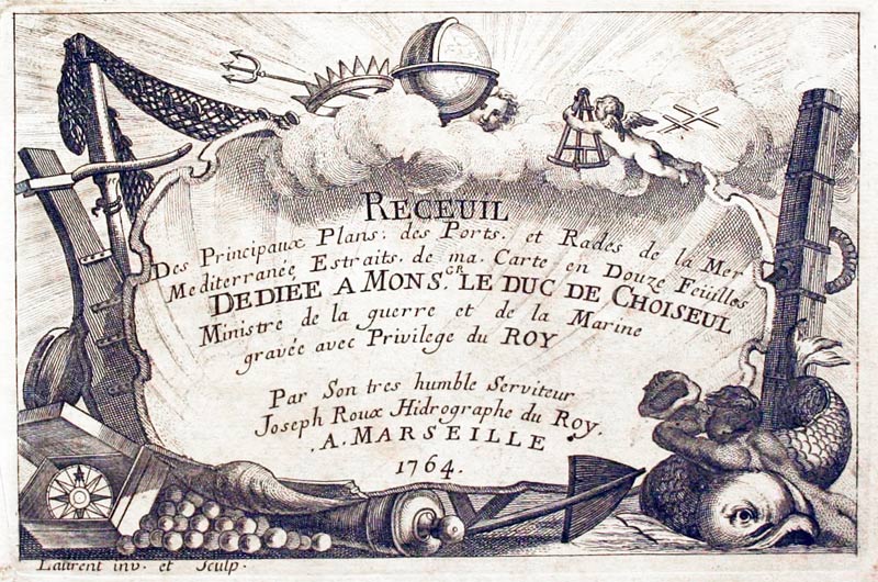
Palermo, Joseph Roux, 1764

27894 Palermo, Joseph Roux, 1764. Price: 60.00
PALERMO
A small engraved chart showing the town and bay with anchorages. Scale. 7 1/2 x 5 inches. Uncoloured. Good condition.
Plate 42 From: Receuil Des Principaux Plans; des Ports, et Rades de la Mer Mediterranée, Estraits, de ma. Carte Douze Feüilles.... Marselle 1764
19th Century - Early Hand Colouring
-

Sicily and Malta, SDUK 1830

30123 Sicily and Malta, S.D.U.K. 1830. Price: 38.00
ITALY III.
An engraved map showing the southern tip with Italy with the Islands of Sicily, Malta and Gozo. 14 3/4 x 11 1/12 inches.
Published by Baldwin & Craddock 47 Paternoster Row, London. Dated January 1st 1830.
Early outline hand colouring. Very light stain in the top right hand corner otherwise good condition.
19th Century
-

Calabria and Sicily, George Washington Bacon, 1891

30483 Calabria and Sicily, George Washington Bacon, 1891. Price: 19.00
ITALY CALABRIA & SICILY.
A detailed colour printed map of the region. 16 3/4 x 11 1/2 inches. Good blank margins. Good clean condition.
From: Complete Atlas of the World
18th Century - Sea Chart
-

Augusta, Sicily Joseph Roux, 1764

27898 Augusta, Sicily, Joseph Roux, 1764. Price: 45.00
AUGUSTA.
A small engraved chart showing the bay and port of Augusta north of Syracuse. Scale and rumb lines. 7 1/2 x 5 inches. Uncoloured. Good condition. Marked Plate 34 but it looks as if this has been amended by hand to 46.
From: Receuil Des Principaux Plans; des Ports, et Rades de la Mer Mediterranée, Estraits, de ma. Carte Douze Feüilles.... Marselle 1764
18th Century - Sea Chart
-

Cape Milazzo, Sicily H.Michelot and L. Bremond

32295 Cape Milazzo, H. Michelot and L. Bremond, 1730. Price: 130.00
PLAN DE LA VILLE DE MELASSE... 1730
An interesting chart of showing the cape and town of Milazzo situated near Messina. Orientated with west at the top. Key listing five places of interest in the town. Compass rose and scale. 10 x 7 inches. Hand coloured. Good condition.
From: Recueil de Plusieurs Plans des Ports et Rades de la Mediterrane


RICHARD NICHOLSON
of CHESTER
Stoneydale
Pepper Street
Christleton
Chester
CH3 7AG
Telephone
01244 336004
International 44 1244 336004

I have been buying and selling antique maps since the early 1960's during which time I had a gallery in Watergate Street, Chester for 30 years. I am now able to offer through my websites a personal service to map and print collectors.

