Antique Maps of Russia
Richard Nicholson of Chester

Established in 1961
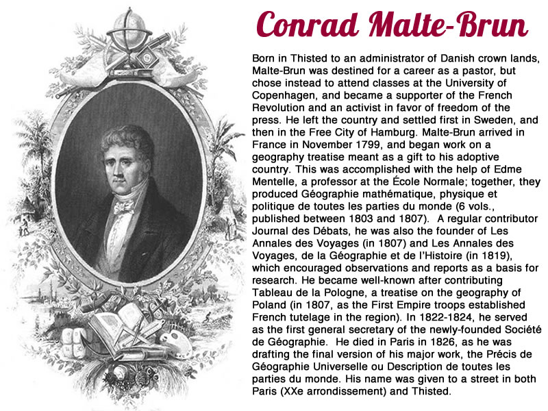
A World of Antique Maps and Prints

The maps on this page are guaranteed to be genuine early specimens published in or around the year stated
Header
Header
19th Century - Early Hand Colouring
-

Northern Russia, Conrad Malte-Brun, 1812

17047 Northern Russia, Conrad Malte-Brun, 1812. Price: 25.00
PARTIE SEPTENT. DE LA RUSSIE D’EUROPE
An engraved map of the northern half of Russia in Europe. Embellished with an uncoloured pictorial title cartouche. 12 x 8 1/2 inches. Some soiling and light foxing in the right hand blank margin otherwise good condition.
From: Precis de la Geographie universelle, ou description de toutes les parties du monde
Mid 18th Century with Early Hand Colouring
-

Northern Russia, Conrad Malte-Brun, 1812

22388 Moscovy Russia, Gilles Robert de Vaugondy, 1748. Price: 28.00
RUSSIE BLANCHE OU MOSCOVIE
An engraved map of Moscovy with title panel and scale. 5 1/2 x 6 1/4 inches. Original outline hand colouring. Good condition.
From: Atlas Portatif Universal
18th Century - Early Hand Colouring
-

Moscovy, Gerard and Leonard Valk, c.1710

23486 Moscovy, Gerard and Leonard Valk, c.1710. Price: 300.00
RUSSIA ALBA, SIVE MOSCOVIA....
An engraved map of the region. The title and scales appear above the map. 23 1/2 x 19 inches. Bright original outline and wash hand colouring. Very small slit at the top of the centre fold, otherwise a nice clean fresh specimen.
From: Atlas Minor by Nicolaes Visscher
Early 18th Century - Early Hand Colouring
-

Moscovy, Nicolaes Visscher, c.1700

23487 Moscovy, Nicolaes Visscher, c.1700. Price: 450.00
NOUVELLE CARTE GEOGRAPHIQUE DU GRAND ROYAUME DE MOSCOVIE REPRESENTANT LA PARTIE SEPTENTRIONALE
A good engraved map of northern Moscovy with superb full original hand colouring. Title cartouche with putti. 28 x 19 1/2 inches. Good condition.
From: Visscher's Atlas Minor
Late 18th Century
-

Southern Russia with Moscow, Franz Johann Joseph von Reilly 1789

24024 Southern Russia with Moscow, Franz Johann Joseph von Reilly, 1789. Price: 120.00
Des Russischen Reiches Statthalterschaften Pleskow, Polozk, Mohilew, Twer, Moskau, Koluga, Wolodimer, Iaroslaw, Tula Smolensko und Nischgorod. Nro. 64.
An engraved map showing part of southern Russia centred on Moscow. Decorative title cartouche. Two scales. 12 x 8 1/4 inches. Some very pale early outline hand colouring. Large blank margins. Fine clean crisp condition.
From: Schauplatz der funf Theile der Welt
An engraved map showing part of southern Russia centred on Moscow. Decorative title cartouche. Two scales. 12 x 8 1/4 inches. Some very pale early outline hand colouring. Large blank margins. Fine clean crisp condition.
From: Schauplatz der funf Theile der Welt
Late 18th Century
-

Archangel,

24026 Archangel, Franz Johann Joseph von Reilly, 1789. Price: 40.00
DES RUSSISCHEN REICHES STATTHALTERSCHAFT ARCHANGEL NRO.66
An engraved map of the northern coast of Russia with the city of Arkhangelsk or Archangel on the Northern Dvina River and the White Sea. A cartouche displays the title and two scales. 10 3/4 x 8 inches. a little early yellow outing hand colouring. Wide blank margins. Good clean crisp condition.
From: Schauplatz der funf Theile der Welt
Archangel was founded in 1584 being a fortified monastery of the archangel Michael. The first port of the Russian Empire to trade with England superceded in the early 18th century with the rising importance of St. Petersburg.
19th Century - Early Hand Colouring
-

Northern Russia, Corad Malte-Brun, 1812

24942 Northern Russia, Corad Malte-Brun, 1812. Price: 32.00
PARTIE SEPTEN DE LA RUSSIE D'EUROPE
An engraved map of northern Russia embellished with an uncoloured pictorial cartouche showing Russian architecture. 11 3/4 x 8 1/2 inches, 300 x 220 mm. Original outline hand colouring. Good condition.
From: Atlas Complet du Precis de la Geographie Universelle...
19th Century - Early Hand Colouring
-

Siberia, Corad Malte-Brun, 1812

24949 Siberia, Conrad Malte-Brun, 1812. Price: 36.00
SIBERIE AVEC L'AMERIQUE RUSSE
An engraved map embellished with an uncoloured pictorial title cartouche showing a bear amongst rocks. 11 1/2 x 8 1/2 inches, 295 x 215 mm. Original outline hand colouring. Good condition.
From: Atlas Complet du Precis de la Geographie Universelle...
18th Century - Early Hand Colouring
-

Russia, G. Robert de Vaugondy, c.1768

25527 Russia, G. Robert de Vaugondy, c.1768. Price: 29.00
CARTE GENERALE DE L'EMPIRE DES RUSSES CONTENANT LA SIBERIE LE TOBOLSK LA SAMOJEDIE ET LE KAMTCHATKA
An engraved map of the region. Includes Japan. Title panel. Original outline hand colouring. 8 x 6 1/4 inches. Good condition.
From: Atlas Portatif Universal
19th Century - Early Hand Colouring
-

Russia in Asia, John Dower, 1834

25637 Russia in Asia, John Dower, 1834. Price: 47.00
RUSSIA IN ASIA, AND TARTARY
An engraved map which includes Japan. 16 x 13 inches. Original outline and wash hand colouring. Fine condition. Paper watermarked J. Whatman 1833. Imprint of the publisher Henry Teesdale at 302 High Holborn, London.
From: A New General Atlas of the World
18th Century
-

Nova Zembla, Jacques Nicolas Bellin, 1758

29165 Novaya Zemlya, Jacques Nicolas Bellin, 1758. Price: 28.00
Partie de la Mer Glaciale Contenant La Nouvelle Zemle et le Pais des Samoides..
A good engraved map of Nova Zemlya embellished with a rococo title cartouche dated 1758. 13 3/4 x 8 1/2 inches. Uncoloured. Good clean condition.
From: l'Histoire générale des voyages
18th Century
-

Nova Zembla, Jacques Nicolas Bellin, c.1760

29166 Nova Zemlya, Jacques Nicolas Bellin, c.1760. Price: 26.00
Carte Des Pais Habités par les Samojedes et Ostiacs...
A good engraved map of Nova Zemlya and the coast of northern Russia embellished with a title cartouche. 9 1/2 x 6 1/4 inches. Uncoloured. Good clean condition.
From: Hydrographique Français' , 1756-65, atlas to accompany Prévost d' Exile's ' Histoire. des Voyages
18th Century
-

Russian Empire, Thomas Conder, c.1778

31231 Russian Empire, Thomas Conder, c.1778. Price: 26.00
A NEW AND CORRECT MAP OF THE RUSSIAN EMPIRE, AS COMPREHENDED IN EUROPE AND ASIA FROM THERE BEST AUTHORITIES AND LATEST IMPROVEMENTS.
An engraved map embellished with a pictorial title cartouche. swags and artefacts shown below the map. 11 x 7 3/4 inches.Uncoloured. Small nick on bottom margin repaired. Very small bottom blank margin which is common. Otherwise good condition.
18th Century
-

Russian Empire, Thomas Bowen, c.1790

31352 Russian Empire, Thomas Bowen, c.1790. Price: 36.00
THE RUSSIAN EMPIRE IN EUROPE & ASIA, WITH THE NORTHERN DISCOVERIES BETWEEN ASIA & NORTH AMERICA BY THOS. BOWEN, GEOGR.
An engraved map with oval title panel. Above the map is shown Engraved for Bankes’s New System of Universal Geography, Published by Royal Authority. 17 3/4 x 12 1/2 inches. Uncoloured. Two small holes in top blank margin and small tear in right hand blank margin repaired. Some discolouration in the right hand blank margin. Original fold creases.
19th Century - Early Hand Colouring
-

Russia, George Frederick Cruchley, 1848

31518 Russia, George Frederick Cruchley, 1848. Price: 34.00
RUSSIA
A clearly engraved map of the country bearing the imprint May 15th 1842. . Publishers rococo cartouche inscribed Cruchley’s Improved Atlas, for Schools & Families. 13 3/4 x 17 1/4 inches. Original outline and wash hand colouring. Very small slit at the end of the centre fold otherwise good condition.
From: Cruchley’s General Atlas for the use of Schools and Private Tuition
18th Century
-

Russia in Erope, Thomas Jefferys c.1770

31667 Russia in Europe, Thomas Jefferys, c.1770. Price: 9.00
RUSSIA OR MOSCOVY IN EUROPE
An engraved map embellished with a pictorial title cartouche bearing the name of the engraver T. Jefferys. 9 x 7 1/8 inches. Uncoloured. Medium toning to the paper. Some light vertical creasing.
17th Century - Miniature
-

Russia Abraham Ortelis c.1603

31668 Russia in Europe, Abraham Ortelius, c.1603. Price: 65.00
RUSSIA
A miniature engraved map of the country with title cartouche. 4 1/2 x 3 1/4 inches. Uncoloured. Three worm holes in the large bottom blank margin. English text on verso. The map is in an ivory tint sunk mount adhered in two places.
18th Century
-

Moscovy John Senex 1741

31992 Western Russia, John Senex c.1741. Price: 24.00
A NEW MAP OF MOSCOVY FROM THE LATEST OBSERVATIONS
An engraved maps with title panel. 7 x 6 1/4 inches. Two original light vertical fold creases. Some very light hand colouring. Good condition.
From: Geography Anatomiz'd or the Geographical Grammar by Patrick Gordon
18th Century - Early Hand Colouring
-

Antique map of Central Russia, Antoni Zatta c.1785

33188 Central Russia, Antoni Zatta c.1785. Price: 140.00
GOVERNI DI MOSCOVIA E WORONEZ COLLE LORO PROVINCIE....
An engraved map centred on Moscow with the region bounded by The Volga River. The upper River Don is shown from its source near Moscow to Czerkask. Engraved by Giuliano Zuliana to appear in “Atlante Novissimo” by Antontio Zatta. 13 x 16 3/4 inches. Decorative title cartouche. Early hand colouring. Original centre fold. Fine clean crisp condition having just been taken from the atlas and not sold previously as a single map.
18th Century - Early Hand Colouring
-

Archangel, Antoni Zatta c.1785.

33189 Archangel, Antoni Zatta c.1785. Price: 68.00
DOVERNO DI ARC ANGEKO E SUE PROVINCIE NELLA RUSSIA EUROPEA..
An engraved map of this large area of western Russia in Europe. Pictorial title cartouche dated 1782. Engraved by Giuliano Zuliana to appear in “Atlante Novissimo” by Antontio Zatta. 13 x 16 3/ inches. Early hand colouring. Original centre fold. Fine clean crisp condition having just been taken from the atlas and not sold previously as a single map.
Late 16th Century
-

Map of Russia and Ukraine, Girolamo Ruscelli 1599
-

Text on verso of Russia and Ukraine, Girolamo Ruscelli 1599


33380 Russia and Ukraine, Girolamo Ruscelli, 1599. Price: 115.00
MOSCHOVIA NUOVA TAVOLA
An early engraved coppeplate engraved map showing the western part of Russia with Ukraine and Crimea. 9 1/4 x 7 1/4 inches. Original centre fold. Uncoloured. Good condition. Italian text on verso. Published by the heirs of Melchoir Sessa.


RICHARD NICHOLSON
of CHESTER
Stoneydale
Pepper Street
Christleton
Chester
CH3 7AG
Telephone
01244 336004
International 44 1244 336004

I have been buying and selling antique maps since the early 1960's during which time I had a gallery in Watergate Street, Chester for 30 years. I am now able to offer through my websites a personal service to map and print collectors.

