Antique Maps of Poitou, Provence,
Roussillon, Saintonge, Savoy & Touraine
Richard Nicholson of Chester

Established in 1961
A World of Antique Maps and Prints

The maps on this page are guaranteed to be genuine early specimens published in or around the year stated
POITOU
18th Century - Original Hand Colouring
-

Poitou and Saitonge, Antonio Zatta, c.1780

32146 Poitou and Saitonge, Antonio Zatta, c.1780. Price: 55.00
Li Governi D'Angiò del Saumurois, della Touraine, e Poitou, D'Aunis, e Saintonge, con quelle D'Angoumois
An engraved map of the Poutou and Saintone with their adjacent regions. Decorative pictorial cartouche dated 1777. 12 x 15 4/4 inches. Original hand colouring. Centre fold as published. Superb clean condition. Straight from the atlas and not sold previously as a single map.
From: Atlante Novissimo
PROVENCE
18th Century - Sea Chart
-

La Ciotat, H.Michelot and L. Bremond, c.1730

8106 La Ciotat, H. Michelot and L. Bremond, c.1730. Price: 95.00
PLAN DU PORTET DU MOLE DE LA CIOTAT
An engraved chart of the port of La Ciota which lies just west of Toulon. Compass rose and rhumb lines. 10 x 7 inches, 250 x 175 mm. Hand coloured. Good condition.
From Recueil de Plusieurs Plans des Ports et Rades de la Mediterranee
19th Century Town Plan - Early Hand Colouring
-

Toulon, S.D.U.K., c.1845

22761 Toulon, S.D.U.K., c.1845. Price: 46.00
TOULON
Engraved plan of the town and port. Panoramic uncoloured engraved view of Toulon from the Outworks on the East Across the base of the plan. 14 x 12 inches, 375 x 305 mm. Early hand colouring. Two light brown marks in the lower right hand blank margin otherwise good condition.
From: Maps of the Society of the Diffusion of Useful Knowledge
18th Century Sea Chart - Original Hand Colouring
-

Port de Nagaye, Jacques Nicolas Bellin, 1764

23861 Port de Nagaye, Jacques Nicolas Bellin, 1764. Price: 42.00
PORT DE NAGAYE ET COSTE VOISINES
Original blue outline and wash colouring. Good condition.
From Le Petit Atlas MaritimePORT DE NAGAYE ET COSTE VOISINES. Original blue outline and wash colouring. Good condition.
From Le Petit Atlas Maritime
18th Century Sea Chart - Original Hand Colouring
-

Cavalaire-sur-Mer, Jacques Nicolas Bellin, 1764

23857 Cavalaire-sur-Mer, Jacques Nicolas Bellin, 1764. Price: 50.00
PLAN DE LA RADE DE CAVALAIRE
A copper engraved map of the coast just west of Cannes. An uncoloured decorative cartouche displays the title and scale. 6 1/2 x 8 1/2 inches. Original blue outline and wash colouring. Good condition.
Map number 125 from volume 5 of Le Petit Atlas Maritime
18th Century - Sea Chart
-

Boux Joseph Roux 1764

27871 Bouc, Joseph Roux, 1764. Price: 45.00
BOUC
A small engraved chart showing the entrance to the harbour of Bouc near Martigues. Scale, depth soundings and anchorage points shown. 7 1/2 x 5 inches. Uncoloured. Good condition.
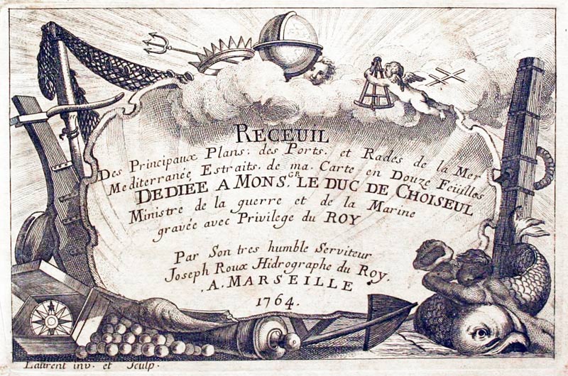
Plate 19 From Receuil Des Principaux Plans; des Ports, et Rades de la Mer Mediterranée, Estraits, de ma. Carte Douze Feüilles.... Marselle 1764
18th Century - Sea Chart
-

Marseille, Joseph Roux, 1764

27872 Marseille, Joseph Roux, 1764. Price: 60.00
RADE DE MARSEILLE
A small engraved chart of thebay and islands showing the entrance to the harbour with depth soundings and anchorage points. Two scales within a panel. 7 1/2 x 5 inches. Uncoloured. Good condition.
Plate 20 From Receuil Des Principaux Plans; des Ports, et Rades de la Mer Mediterranée, Estraits, de ma. Carte Douze Feüilles.... Marselle 1764
18th Century - Sea Chart
-

Le Brusc, Joseph Roux, 1764

27874 Le Brusc, Joseph Roux, 1764. Price: 50.00
RADE DU BRUSC
A small engraved chart showing the bay with the town on Sanary-sur-Mere. Depth soundings and anchorage point shown. 7 1/2 x 5 inches. Uncoloured. Good condition.
Plate 22 From Receuil Des Principaux Plans; des Ports, et Rades de la Mer Mediterranée, Estraits, de ma. Carte Douze Feüilles.... Marselle 1764
18th Century - Sea Chart
-

Toulon, Joseph Roux, 1764

27875 Toulon, Joseph Roux, 1764. Price: 55.00
TOULON
A small engraved chart showing the entrance to the bay and harbour with scale. Compass pointer, depth soundings and anchorage points. 7 1/2 x 5 inches. Uncoloured. Good condition.
Plate 23 From *Receuil Des Principaux Plans; des Ports, et Rades de la Mer Mediterranée, Estraits, de ma. Carte Douze Feüilles.... Marselle 1764
18th Century - Sea Chart
-

Villefranche, Joseph Roux, 1764

27879 Villefranche, Joseph Roux, 1764. Price: 62.00
VILLE FRANCHE
A small engraved chart showing the entrance to the harbour with scale. Depth soundings and anchorage points shown. 7 1/2 x 5 inches. Uncoloured. Good condition.
Plate 27 From Receuil Des Principaux Plans; des Ports, et Rades de la Mer Mediterranée, Estraits, de ma. Carte Douze Feüilles.... Marselle 1764
18th Century - Military
-

Toulon, Claude du Bosc, c.1740

29549 Toulon, Claude du Bosc, c.1740. Price: 48.00
PLAN OF THE TOWN AND HARBOUR OF TOULON BESIEGED AUGUST 1707
An interesting engraved plan of the town and surrounding area. The rococo cartouche displays the title and key to 7 places of interest. Scale and compass pointer. 16 1/2 x 12 3/4 inches. Uncoloured. Good clean condition.
18th Century - Original Hand Colouring
-

Dauphine and Provence, Antonio Zatta c.1780

32143 Dauphine and Provence, Antonio Zatta c.1780. Price: 100.00
Li Governi del Delfinato edi Provenza la Contea Venaissin ed il Princip d'Orange di nuova projezion
An engraved map of the regions of Dauphine and Provence including the Côte d’Azur. Decorative pictorial cartouche which is dated 1777. 12 x 16 inches. Original hand colouring. Centre fold as published. Superb clean condition. Straight from the atlas and not sold previously as a single map.
From: Atlante Novissimo
17th Century - Sea Chart
-

Chart of the coast from River Loire to Olerson, Pieter Good 1676

33415 West Coast of France Loire - Oleron, Pieter Goos, 1676. Price: 140.00
DE CUSTEN VAN POICTOU, XANTOIGNE EN EEN GEDEELT VAN BRETAIGNE VAN BOELYN TOT AEN DE RIVIER VAN BOUREAUX
An interesting early chart showing part of the coast of France from north of the entrance to the River Loire to south of La Rochelle and the island of Oleron. Decorative title cartouche, sailing ship, two compass rroses and rhumb lines. Plate numbered 47. 20 1/2 x 16 1/2 inches. Lightly toned. Very light water staining in top left and right hand corners. Very small split at the bottom of the centre fold. Otherwise good condition.
From: Jacobsz Sea Atlas
Large Detailed 18th Century Map of Southern France
-

Map of South East France by William Faden 1799

22534 South East France, William Faden 1799. Price: 120.00
THE SOUTH EASTERN PART OF FRANCE WHICH INCLUDES ROUSSILLON-LANGUEDOC, WITH A GREAT PORTION OF ROUERGUE AND AUVERGNE-PROVENCE-DAUPHINE, AND THE WHOLE FRONTIER OF ITALY
A mist impresive large and detailed engraved map of these regions of Southern France. The tile appears above the map and below are four scales and the publishers imprint dated 1799. 30 1/4 x 21 inches. Original outline hand colouring. Original centre fold. Fine clean condition. Taken from the atlas and therefore not previously sold as a single map.
From: A New General Atlas
ROUSSILLON
xx
-

Roussillon, France Robert de Vaugondy

33598 Roussillion, Robert de Vaugondy, c.1748. Price: 25.00
GOUVERNEMENS ĠENÉRAUX DE FOIX ET DE ROUSSILLION ET LES PAYS CIRCONVOISINS...
An engraved map of the region with a panel dated 1738 showing the title and scale. 8 x 6 1/4 inches. Original outline hand colouring. Good condition with wide blank margins. Good clean condition.
SAINTONGE
17th Century - Original Hand Colouring
-

Saintonge, Frederick de Wit, c.1700

29323 Saintonge, Frederick de Wit, c.1700. Price: 140.00
XINTONGE, AVEC LE AYS D'AU;NIS, LE BROUAGENAIS, TERRED'ARVERT &C.
An engraved map of Saintonge including the islande of Re and Oleron. The title and scales are displayed within a decorative cartouche with putt. 21 x 18 3/4 inches. Original hand colouring. Light crease on the left hand side. Small slit at the bottom of the centre fold. Otherwise good condition. Good blank margins.
17th Century - Original Hand Colouring
-

Saintonge, Jan Jansson, c.1649

29324 Saintonge, Jan Jansson, c.1649. Price: 140.00
LA SAINTONGE VERS LE MIDY AVECQ LE BROVAGEAIS TERRE D'AVERT &C.
A good 17th century map of Saintonge showing the entrance to Garonne River with ships. Embellished with two decorative cartouches displaying the title and two scales. 22 x 17 1/4 inches. Original hand colouring. Latin text on verso. Small slit at the top of the centre fold. Two short tears in the left and right margins. Otherwise good condition with no staining.
18th Century - Original Hand Colouring
-

Poitou, Aunis, Limosin, Auvergne. Robert de Vaugondy / Charles Francois Delamarche, 1812.

29722 Poitou, Aunis, Limosin, Auvergne. Robert de Vaugondy / Charles Francois Delamarche, 1812. Price: 25.00
POITOU; AUNIS, SAINTONGE ET ANGOUMOIS, LA MARCHE, LIMOSIN ET AUVERGNE. PAR ROBERT DE VAUGONDY GEOGRAPHE CORRIGES PAR C. F. DELAMARCHE SON SUCCESSEUR
A good engraved map of the region with a shaped title panel. List of departments and two scales. 11 1/4 x 9 1/2 inches. Original outline hand colouring. Good condition. Wide blank margins.
SAVOY
Sorry none in stock at present

RICHARD NICHOLSON
of CHESTER
Stoneydale
Pepper Street
Christleton
Chester
CH3 7AG
Telephone
01244 336004
International 44 1244 336004

I have been buying and selling antique maps since the early 1960's during which time I had a gallery in Watergate Street, Chester for 30 years. I am now able to offer through my websites a personal service to map and print collectors.

