Antique Maps of Turkey
Richard Nicholson of Chester

Established in 1961
A World of Antique Maps and Prints

The maps on this page are guaranteed to be genuine early specimens published in or around the year stated
TURKEY
18th Century Chart
-

Chart of the Dardanelles, J. N. Bellin 1764

5713 Dardanelles, Jacques-Nicolas Bellin, 1764. Price: 68.00
CARTE DE L'ENTREE DU CANAL DES DARDANELLES
An interesting 18th engraved chart embellished with an uncoloured rococo cartouche. 7 x 8 inches, 175 x 205 mm. Original blue outline and wash colouring. Good condition. From Le Petit Atlas Maritime.
19th Century
-

Northern Turkey by S.D.U.K. 1830

21155 Turkey, S.D.U.K. 1830. Price: 33.00
TURKEY I
Containing the Northern Provinces. A detailed map of the region. 14 1/2 x 11 3/4 inches. Original outline hand colouring. Published by Baldwin & Craddock and dated 1830. Published under the Superintendence of the Society for the Diffusion of Useful Knowledge. Good clean undamaged condition.
19th Century
-

Turkish Empire, Archibald Fullarton, 1862

24409 Turkish Empire, Archibald Fullarton, 1862. Price: 30.00
TURKISH EMPIRE
A large detailed colour lithograph map with two instes. 20 1/2 x 16 1/2 inches. Small slit at the bottom of the centre fold otherwise good condition.
From: The Royal Illustrated Atlas published by Archibald Fullarton and Company
19th Century - Early Hand Colouring
-

Chronological Table, C. V. Lavoisne, 1830

27545 Chronological Table, C. V. Lavoisne, 1830. Price: 22.00
GENEALOGICAL, HISTORICAL, & CHRONOLOGICAL MAP OF THE EMPIRE OF CONSTANTINOPLE FROM ARADIUS, 395, TO ISAAC ANGELUS, 1185
A fascinating table which would make a most interesting wall decoration. 20 1/2 x 16 1/2. Original wash hand colouring. Good condition.
From: Lavoisne’s Complete Genealogical, Historical, Chronological, and Geographical Atlas. The fourth edition printed and published by J. Barfield in London
18th Century Sea Chart
-

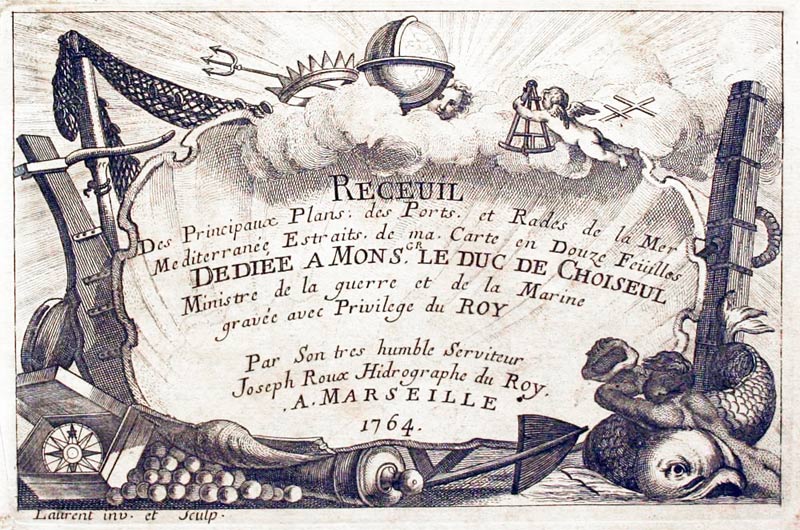
Sigacik, Turkey by Joseph Roux, 1764

27969 Sigacik, Joseph Roux, 1764. Price: 40.00
PLAN DU PORT SIAGI
An interesting 18th century chart of the port of Sigacik a seaside neighborhood of Seferihisar ilçe of İzmir Province, Turkey. Also shows the small island of Esek Adasi. Scale. 7 1/2 x 5 inches. Uncoloured. Good clean condition. Straight from the atlas and not previously sole as a single map.
Plate 108 From Receuil Des Principaux Plans; des Ports, et Rades de la Mer Mediterranée, Estraits, de ma. Carte Douze Feüilles.... Marselle 1764
18th Century Sea Chart
-

Izmir, Turkey by Joseph Roux, 1764

27972 Izmir Joseph Roux, 1764. Price: 45.00
GOLFE DE SMIRNE
A small engraved chart showing the town of Izmir, founded by the Greeks and named Smyma. The chart shows the whole bay with depth sounding and anchorage points. 7 1/2 x 5 inches. Uncoloured. Good condition. Plate 50 From Receuil Des Principaux Plans; des Ports, et Rades de la Mer Mediterranée, Estraits, de ma. Carte Douze Feüilles.... Marselle 1764
18th Century Sea Chart
-

Karaburun Peninsula., Turkey by Joseph Roux, 1764

27973 Foolery, Karaburun Peninsula, Joseph Roux, 1764. Price: 40.00
PLAN DE LA RADE DE FOLLERY
A small engraved chart showing the western coast of the Karaburun Peninsula north of Izmir. Shows Foca and the outlying islands. 7 1/2 x 5 inches. Uncoloured. Good condition. Straight from the atlas and so not been previously sold as a single map.
Plate 104 From Receuil Des Principaux Plans; des Ports, et Rades de la Mer Mediterranée, Estraits, de ma. Carte Douze Feüilles.... Marselle 1764
18th Century Sea Chart
-

Chart of the Gulf of Candarli, Turkey by Joseph Roux, 1764

27974 Gulf of Candarli, Joseph Roux, 1764. Price: 40.00
GOLFE DE ST. DRELY
A small engraved chart showing part of the coast of the Aegean Sea with the Gulf of Candarli and the Bay of Aliaga situated near Turkey’s Izmir Province. 7 3/4 x 5 inches. Uncoloured. Small right hand blank margin otherwise good condition.
Plate 103 From: Receuil Des Principaux Plans; des Ports, et Rades de la Mer Mediterranée, Estraits, de ma. Carte Douze Feüilles.... Marselle 1764
18th Century Sea Chart
-

Marmara, Turkey by Joseph Roux, 1764

27978 Marmara, Joseph Roux, 1764. Price: 45.00
CANAL DE CONSTANTINOPLE.
A small engraved chart of the Sea of Marmara with the Turkish peninsular that projects into the sea along with the Island of Marmara and other small islands. . Shows the depth soundings and anchorage points. 7 1/2 x 5 inches. Uncoloured. Good condition. Plate 99 From Receuil Des Principaux Plans; des Ports, et Rades de la Mer Mediterranée, Estraits, de ma. Carte Douze Feüilles.... Marselle 1764
18th Century Sea Chart
-

Marmara, Turkey by Joseph Roux, 1764

27979 Dardanelles, Joseph Roux, 1764. Price: 45.00
ENTREE DU CANAL DE CONSTANTINOPLE
A small engraved chart the Dardanelles Shows the entrance to the Bosphorus with the fortifications on the two coasts along with depth soundings and anchorage points. 7 1/2 x 5 inches. Uncoloured. Good condition.
Plate 98 From Receuil Des Principaux Plans; des Ports, et Rades de la Mer Mediterranée, Estraits, de ma. Carte Douze Feüilles.... Marselle 1764
Late 17th Century
-

Part of Turkey with Izmir and Lesbos, Hendrik Doncker, c.1679

28078 Part of Turkey & Lesbos, Hendrik Doncker, c.1679. Price:160.00
SMYRNE EN DE ETLANDEN SCIO EN METELINO
A 17th chart of the region including part of the island of Lesbos and Chios with part of the mainland including Izmir. Decorative title cartouche. Compass rose and thumb lines. Scales panel. Plate numbered 19 in the bottom right hand corner. Orignal centre fold, 19 3/4 x 15 1/2 inches. Original centre fold. Small tear in the bottom blank margin repared. A few nicks on the edge of the bottom blank margin. Tiny pinhole on a blank rea of Lesbos near the centre fold. Otherwise good condition.
17th Century - Miniature
-

The Turkish Empire, Pieter van den Keere, c.1646

29805 The Turkish Empire, Pieter van den Keere, c.1646. Price: 95.00
THE TURKISH EMPIRE
A miniature engraved map with a banner displaying the title. 4 3/4 x 3 1/4 inches. Part of a description of the Turkish Empire in English on verso. Uncoloured. Light discolouration in the top blank margin caused by the map being taped onto a sunk mount in the past. Otherwise good condition.
From: A Prospect of the Most Famous Parts of the World
18th Century
-

Turkey in Europe, Herman Moll, c.1740

30104 Turkey in Europe, Herman Moll, c.1740. Price: 40.00
THE NORTH PART OF TURKY IN EUROPE, SLAVONIA &c By H. Moll Geographer
An engraved map of the region. Title panel with scale. 10 1/4 x 7 3/4 inches. Hand coloured. Slight traces on verso at top of tape used to mount the map. Good condition.
19th Century
-

Turkey in Europe, George Frederick Cruchley, 1848

31532 Turkey in Europe, George Frederick Cruchley, 1848. Price: 39.00
TURKEY IN EUROPE, AND GREECE
A clearly engraved map bearing the imprint August 1st 1842. Publishers rococo cartouche inscribed Cruchley’s Improved Atlas, for Schools & Families. 17 1/4 x 13 3/4 inches. Original outline and wash hand colouring. Matching ink blots at the top and bottom of the map. Otherwise good condition.
From: Cruchley’s General Atlas for the use of Schools and Private Tuition
Late 19th Century Plan
-

Constantinople Archibald Fullarton c.1895

32003 Constantinople, Archibald Fullarton, c.1895. Price: 19.50
CONSTANTINOPLE ACCORDING TO THE SURVEY OF DUFOUR AND ADMIRALTY CHARTS
A colour lithograph map with a key listing 32 places of interest. 9 x 5 1/2 inches. Good clean condition.
Early 19th Century - Originl Hand Colouring
-

Ancient Greece and Turkey Robert Wilkinson c.1815

32004 Ancient Greece and Turkey, Robert Wilkinson c.1815. Price: 42.00
REDITUS DECEM MILLIUM GRAECORUM
An interesting engraved map of ancient Greece and Turkey extending south to Judea. Publishers imprint beneath dated 1809. 11 1/4 x 8 3/4 inches. Original outline and wash hand colouring. Fine clean condition with good margins. Straight from the atlas and not previously sold as a single map.
From: Atlas Classica
Late 16th Century
-

Asia Minor, Egypt nd Carthage Abraham Ortelius 1595

32007 Turkey, Egypt and Carthage, Abraham Ortrelius 1595. Price: 240.00
NATOLIAE QUAE OLIM ASIA MINOR, NOVA DESCRIPTIO / AEGYPTI RECTIOR DESCRIPTIO / CARTHAGINIS CELEBERRIMIINUS TYPUS
Three maps on one sheet by this famous 16th century cartographer. The one on the left shows Asia Minor, Cyprus, Crete and the Eastern Mediterranean. Top right is a map showing part of Egypt with the Nile as far south as Aswan based on Paolo Forlani’s map of 1556.. The map beneath shows the city of Cartahge and surrounding area. Together they measure some 19 x 12 1/2 inches. Original centre fold. Latin text on verso. Uncoloured. Total of five small brown marks in the blank margins. Otherwise find clean crisp condition. This map has come straight from the atlas and is offered for the first time as a single map.
From: Theatrum Orbis Terrarum
17th Century
-

The Turksih Empire, Richard Blome c.1680

33329 The Turkish Empire, Richard Blome, c.1680. Price: 130.00
A MAPP OF THE ESTATES OF THE TURKISH EMPIRE IN ASIA AND EUROPE / DDESIGNED BY NONSR. SANSON GEOGRAPHER TO THE FRENCH KING
An interesting copper engraved map being rather unique in that it is printed from two printing plates. The narrow gap between the two plates can be seen on the left hand side of the map. There are specimens of this map that bear a coat of arms with a dedication to To the Right Worshipfull the Governour, Deputy Governour & Court of Assistance of the Company of Merchants Trading into the Levant Seas. This specimen, however, has a coat of arms and a dedication to Ye Rt. Honble. Heneage Earle of Winchelsy Viscount MaidstonBaron Fitz Herbert of Eastwell Lord of the Royal Mannour of Wye and Lord Leuitenant of Kent and Somersetshir. 16 1/4 x 11 inches. Original centre fold and two other original vertical folds. Uncoloured. Minor split at the bottom of the cntre fold repaired. The map is in very good clean crisp condition.
19th Century
-

The Turksih Empire, Richard Blome c.1680

33353 Turkey in Europe, John Tallis, c.1853. Price: 34.00
TURKEY IN EUROPE
A decorative engraved map showing The Balkans with northern Greece, Bulgaria, Albania, Serbia and Macedonia. Three inset vignette views of The Bosphorus and Constantinople, Ali Pash and a Greek Caloyer. The map is set within a patterned border. 12 3/4 x 9 3/4 inches. Some original outline hand colouring with additional more modern hand colouring. Small slits at the top and bottom of the original centre fold. A little very light creasing otherwise good clean condition.
Drawn and engraved by J. Rapkin for Tallis’s The Illustrated Atlas
Large 18th Century Map with Early Colouring
-

Map of Turkey in Erope by William Faden 1795

22543 Turkey in. Europe, William Faden, 1795. Price: 130.00
EUROPEAN DOMINIONS OF THE OTTOMANS OR TURKEY IN EUROPE
An impressive large and detailed map of the region. The title is displayed within a large decorative uncoloured cartouche with military weapons, putti and fruit. Within in the cartouche is the publishers imprint dated 1795. 29 x 21 1/2 inches. Original outline hand colouring. Original centre fold. 5 inch split at the bottom of the centre fold otherwise good condition. Good heavy paper. Taken from the atlas and therefore not previously sold as a single map.
From: A New General Atlas
Turkey in Ancient Times
-

Turkey in Ancient Times, Dr. Henry Kiepert c.1902

33444 Turkey, Dr. Henry Kiepert, c.1902. Price: 19.00
ASIA CITERIOR
A lithograph map showing the regions of Turkey, Cyprus, Palestine and Mesopotamia in ancient times. 17 1/4 x 13 1/2 inches. Original centre fold. Good condition.
From: Atlas Antiquus published in Berlin
GEORGIA
18th Century - Early Hand Colouring
-

Kingdom of Colchin Pieter van der Aa, c.1740

32016 Kingdom of Colchis, Pieter van der Aa, c.1740. Price: 220.00
MINGRELIE AUTREFOIS COLCHIS PAYS BAIGNÉ AU COUCHANT PAR LA MER NOIRE
A most interesting engraved map of the ancient Kingdom Colchis in the regin of Mingrelia on the coast of the Black Sea in Western Georgia. Orientated with northeast at the top. The title is shown within an uncoloured pictorial cartouche with figures. This shows the name of the publisher J. Covens and C. Mortier. Uncoloured scale cartouche and compass rose. 13 1/2 x 11 inches. Original outline and wash yellow colouring to the land and border area. Superb clean condition with very large blank margins on all four sides some 5 inches or more wide.


RICHARD NICHOLSON
of CHESTER
Stoneydale
Pepper Street
Christleton
Chester
CH3 7AG
Telephone
01244 336004
International 44 1244 336004

I have been buying and selling antique maps since the early 1960's during which time I had a gallery in Watergate Street, Chester for 30 years. I am now able to offer through my websites a personal service to map and print collectors.

