Antique Maps of Africa
Richard Nicholson of Chester

Established in 1961
A World of Antique Maps and Prints

The maps on this page are guaranteed to be genuine early specimens published in or around the year stated
19th Century
-

Africa, SDUK 1844

33404 Africa, S.D.U.K. 1844. Price: 80.00
AFRICA
A map of the whole continent engraved by J. & C. Walker and dated 1839. It is interesting to see the lack of detail in the interior of the continent. 15 1/2 x 12 1/2 inches. Uncoloured. Plain on verso. Good condition. This map has been taken from the atlas and therefore not been offered for sale as a single map before. The atlas is dated 1844.
From the atlas published for the Society for Diffusion of Useful Knowledge
NORTH AFRICA
17th Century - Miniature
-

Nubia, Alain M. Mallet, 1685

12420 Nubia, Alain M. Mallet, 1685. Price: 28.00
NUBIE
A small engraved map of the region embellished with a decorative title cartouche. 4 x 6 inches. Uncoloured. Good condition.
17th Century
-

Barbary Coast, Frederick de Wit, c.1710

13250 Barbary Coast, Frederick de Wit, c.1710. Price: 160.00
THE SEA COAST OF BARBARY FROM CAPE DE TENES TO CAPE DE ROSA
Engraved chart with a decorative title cartouche and two small inset plans of Argier and Bona. Two compass roses and rhumb lines. Uncoloured. 20 x 15.5 inches, 500 x 390 mm. Good condition
18th Century - Sea Chart
-

Barbary Coast, John Seller, c.1770

13251 Barbary Coast, John Seller, c.1770. Price: 96.00
THE SEA COAST OF BARBARY FROM CAPE DE TENES TO CAPE DE ROSA
Engraved chart with a decorative title cartouche and two small inset plans of Argier and Bona. Two compass roses and rhumb lines. Uncoloured. 20 x 15.5 inches, 500 x 390 mm. Good condition
19th Century - Early Hand Colouring
-

Barbary Coast, North Africa Conrad Malte-Brun 1812

20083 Barbary Coast, North Africa Conrad Malte-Brun 1812. Price: 29.00
BARBARIE
An engraved map of the Barbary Coast embellished with an uncoloured pictorial title cartouche showing a dwelling, lion and ostrich. Includes Sardinia, Sicily and Malta. 11.75 x 8.5 inches. Original outline hand colouring. Good condition.
From: Atlas Complet du Précis de la Géographie Universelle... 1811
19th Century - Early Hand Colouring
-

Barbary Coast, Conrad Malte-Brun, 1837

22063 Barbary Coast, Conrad Malte-Brun, 1837. Price: 29.00
BARBARIE 1834
An engraved map of the Barbary Coast with original outline hand colouring. Includes Malta. 11 3/4 x 8 3/4 inches. Good condition. Wide blank margins. The map is not as toned as it appears in the illustration.
From: Atlas Complet du Precis de la Geographie Universelle
19th Century - Early Hand Colouring
-

Ancient Africa and Arabia Conrad Malte-Brun 1812

24898 North Africa and Arabia in Ancient Times, Conrad Malte-Brun, 1812. Price: 40.00
AFRIQUE ANCIENNE
An engraved map showing northern Africa, Arabia and the Mediterranean in ancient times. 12 1/4 x 8 1/4 inches. Original early outline hand colouring. Good condition.
From: Atlas Complete du Précis de la Géographie Universelle
Late 16th Century - Early Colouring
-

Anfa, Azenmour, Diu & Goa, G Braun & Franz Hogenberg
-

French text for Anfa, Azenmour, Diu & Goa, G Braun & Franz Hogenberg


27133 Anfa, Azenmour, Diu & Goa, Georg Braun & Franz Hogenberg, c.1579. Price: 350.00
Anfa, Quibusdam Anaffa / Azzaamurum / Diiv / Goa fortissima Indiae urbs in Christianorum potestatem anno Salutis 1509
An impressive late 16th century copper engraving displaying four bird’s eye view of towns.
At the top left is the ancient city of Anfa which now lies to the west of Casablanca in Moocco. First occupied by the Berbers in the 10th century and then in the 15th century by the Romans. It became an important port and safe refuge for pirates which ended in the Portuguese destroying the town in 1468.
Top right is the is the city of Azemmour captured by the Portuguese 1513. An important fortress in North Africa at the time.
The centre image stretching right across is of the Indian city of Diu situated on the island of Diu which connects now by a bridge to the state of Gujarat.
The bottom image is of the city of Goa captured by the Portuguese in 1510 and became the capital of Portuguese India and became the centre of Portuguese power in Asia.
A most interesting engraving illustrating four important cities in the history of the Portuguese Empire during this period. French text on verso. Original centre fold. 18 1/2 x 13 1/4 inches. Fine clean condition.
From: Civitates Orbis Terrarum
18th Century - Sea Chart
-

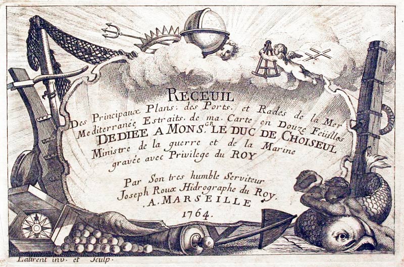
Oran, Joseph Roux, 1764

27900 Oran, Joseph Roux, 1764. Price: 43.00
ORAN
A small engraved chart showing the town of Oran on the Algerian coast with the bay and anchorages. Scale. 7 1/2 x 5 inches. Uncoloured. Good condition.
Plate 48 From Receuil Des Principaux Plans; des Ports, et Rades de la Mer Mediterranée, Estraits, de ma. Carte Douze Feüilles.... Marselle 1764
18th Century - Sea Chart
-

Arzeni, Joseph Roux, 1764

27901 Arzeni, Joseph Roux, 1764. Price: 40.00
Arzeou or Arzeni
A small engraved chart showing the bay and anchorage points on the Barbary coast. 7 1/2 x 5 inches. Uncoloured. Good condition.
Plate 49 From Receuil Des Principaux Plans; des Ports, et Rades de la Mer Mediterranée, Estraits, de ma. Carte Douze Feüilles.... Marselle 1764
19th Century - Early Hand Colouring
-

North Africa, John Arrowsmith, 1830

31216 North Africa, John Arrowsmith, 1830. Price: 25.00
NORTH AFRICA
An engraved map of the coast of North Africa shown in two sections on one sheet. Published by John Arrowsmith No. 10 Soho Square. 9 1/2 x 7 3/4 inches. Original outline hand colouring. Good condition.
19th Century - Early Hand Colouring
-

North Africa, Conrad Malte-Brun, 1837

31217 North Africa, Conrad Malte-Brun, 1837. Price: 30.00
BARBARIE
An engraved map of North Africa with part of the Mediterranean Sea. 11 3/4 x 8 1/2 inches. Original outline hand colouring. Good condition with wide blank margins.
18th Century - Early Hand Colouring
-

Ancient North Africa, Robert Wilkinson 1798

31218 Ancient North Africa, Robert Wilkinson, 1798. Price: 30.00
AFRICA ANTIQUA
An interesting engraved map of North Afriuca in Ancient Times. The eastern par of the coast is continued within an inset panel titled Libya. Publishers imprint beneath London Published Dec. 1st 1798 by R. Wilkinson No. 58 Cornhill. 11 8 1/2 inches. Attractive early outline and wash hand colouring.
From: Atlas Classica
16th Century
-

North Africa Martin Walseemuller 1541

32027 North Africa, Martin Waldseemuller, 1541. Price: 490.00
UNTITLED
An early Ptolemaic woodcut map of North Africa including the Red Sea, Egypt and Libya. Drawn by Lorenz Fries and published in Strasbourg. About 17 1/2 x 1 4 1/2 inches. Uncoloured. Latin text on verso with an early manuscript note in French in the blank margin. Centre fold as published. Small binding hole in the top blank margin. Tiny water stain on the edge of the bottom right hand side blank margin. Small traces of tape on the edges on verso where the map appears to have been in a sunk mount in the past. A little very light creasing but otherwise good clean undamaged condition.
Claudis Ptoelmy - A Greek astronomer and geographer working in Alexandria c. 150 A.D.
Martin Waldseemuller c.1475 - c.1522. Born near Freiburg, North Germany. Produced the first large printed world map and the first collection of modern maps
Lorenz Fries c.1490-c.1531. Physician, astrologer and geographer from Colmar, Alsace.
Late 16th Century
-

Asia Minor, Egypt nd Carthage Abraham Ortelius 1595

32007 Turkey, Egypt and Carthage, Abraham Ortrelius 1595. Price: 240.00
NATOLIAE QUAE OLIM ASIA MINOR, NOVA DESCRIPTIO / AEGYPTI RECTIOR DESCRIPTIO / CARTHAGINIS CELEBERRIMIINUS TYPUS
Three maps on one sheet by this famous 16th century cartographer. The one on the left shows Asia Minor, Cyprus, Crete and the Eastern Mediterranean. Top right is a map showing part of Egypt with the Nile as far south as Aswan based on Paolo Forlani’s map of 1556.. The map beneath shows the city of Cartahge and surrounding area. Together they measure some 19 x 12 1/2 inches. Original centre fold. Latin text on verso. Uncoloured. Total of five small brown marks in the blank margins. Otherwise find clean crisp condition. This map has come straight from the atlas and is offered for the first time as a single map.
From: Theatrum Orbis Terrarum
19th Century - Early Hand Colouring
-

Ancient North Africa S.D.U.K. c.1840

32682 North Africa in Ancient Times, S.D.U.K. c.1840. Price: 27.00
ANCIENT AFRICA OR LIBYA PART I.
A detailed engraved map of the north coast of Africa in ancient times. Includes the Iberian Peninsular and Balearic Islands with few detail. Also includes the island of Sardinia. 15 1/2 x 12 1/2 inches. Original outline hand colouring. Imprint of the publisher Charles Knight & Co. 22 Ludgate Street beneath. Good clean undamaged condition.
19th Century - Early Hand Colouring
-

North Africa - Tripoli S.D.U.K. c.1837

32684 North Africa - Tripoli, S.D.U.K. c.1837. Price: 26.00
NORTH AFRICA OR BARBARY IV TRIPOLI
A detailed engraved map of the region 15 1/2 x 12 1/2 inches. Original outline hand colouring. Imprint of the publisher Baldwin & Craddock beneath dated 1837. Good clean undamaged condition.
19th Century - Early Hand Colouring
-
North Africa - Tunis and Tripoli S.D.U.K. c.1837
32685 North Africa - Tunis & Tripoli, S.D.U.K. c.1837. Price: 26.00
NORTH AFRICA OR BARBARY III TUNIS AND PART OF TRIPOLI
A detailed engraved map of the region 15 1/2 x 12 1/2 inches. Original outline hand colouring. Imprint of the publisher Baldwin & Craddock beneath dated 1836. Good clean undamaged condition.
19th Century - Early Hand Colouring
-

North Africa - Tunis and Egypt S.D.U.K. c.1837

32686 North Africa - Tunis & Egypt, S.D.U.K. c.1837. Price: 26.00
NORTH AFRICA OR BARBARY V PARTS OF TRIPOLI AND EGYPT
A detailed engraved map of the region 15 1/2 x 12 1/2 inches. Original outline hand colouring. Imprint of the publisher Baldwin & Craddock beneath dated 1837. Good clean undamaged condition.
18th Century - Sea Chart
-

Chart of part of the Barbary Coast, Joseph Roux 1764

27912 Part of the Barbary Coast, Joseph Roux, 1764. Price: 34.00
BARBARY COAST
A small engraved chart showing part of the Barbary Coast with the Port of Geneves and the town of Bone. 7 1/2 x 5 inches. Uncoloured. Good condition.
Plate 51 From: Receuil Des Principaux Plans; des Ports, et Rades de la Mer Mediterranée, Estraits, de ma. Carte Douze Feüilles.... Marselle 1764
19th Century - Decorative
-

Map of Northern Africa by John Tallis c.1851

33388 Northern Africa, John Tallis, 1851. Price: 56.00
NORTHERN AFRICA
A decorative engraved map of North Africa set within an ornate border. The map is embellished with five and coloured the vignette views of Mogador, Algiers, Morocco, Constantine and Tunis. Some 12 3/4 x 9 1/2 inches. Original outline hand colouring to the map area. Other colouring is later. Slight trimming to the top of the border which is common, otherwise good condition.
From: R. Montgomery Martin's Illustrated Atlas published by John Tallis
Late 18th Century - Early Hand Colouring
-

North Africa in Ancient Times, Robert Wilkinson, 1798.

33535 North Africa in Ancient Times, Robert Wilkinson, 1798. Price: 30.00
AFRICA ANTIQUA
An engraved historical map showing the northern coast continued with an inset map titled Libya. 11 x 8 3/4 inches. Publisher’s imprint dated 1798. . Original outline and wash hand colouring. Good condition.
From: Atlas Classica.
17th Century
-

North Africa, Jan Jansson c.1680

33631 North Africa, Jan Jansson c.1680. Price: 95.00
AFRICAE PROPRIAE TABULA IN QUA, PINICA REGNA UIDES, TYRIOS, ET AGENORIS URBEM
An engraved map based upon an earlier map by Abraham Ortelius. It shows in ancient times part of the coast of north Africa showing the present day Tunisia and Libya. It shows part of Sicily as well as Malta and its neighbouring islands. Two decorative cartouches display the title and text. 20 1/2 x 14 1/2 inches. Uncoloured. Small Chethams Library stamp in the sea area. Original centre fold. Very lightly toned. Two spots in the wide blank margins. Smnall slit at the top of the centre fold. Otherwise good condition
This map comes from a Jansson atlas I purchased at Christies back in 1980
MOROCCO
19th Century - Early Hand Colouring
-

Morocco, Edward Weller, 1858

18338 Morocco, Edward Weller, 1858. Price: 22.00
MOROCCO BY EDWD. WELLER, FRGS
A lithograph map. Inset map of the Straits of Gibraltar. 16 3/4 x 11 1/2 inches. Original outline hand colouring.
From: The Weekly Dispatch Atlas
18th Century - Sea Chart
-

Tangiers, Joseph Roux, 1764

27899 Tangiers, Joseph Roux, 1764. Price: 45.00
TANGER
A small engraved chart showing the town and bay with anchorages Scale. 7 1/2 x 5 inches. Uncoloured. Good condition.
Plate 47 From: Receuil Des Principaux Plans; des Ports, et Rades de la Mer Mediterranée, Estraits, de ma. Carte Douze Feüilles.... Marselle 1764
19th Century
-

Morocco, George Washington Bacon, 1891

30481 Morocco, George Washington Bacon, 1891. Price: 14.50
MAROCCO
A detailed colour printed map of the country. Inset map of the Straits of Gibraltar. 16 3/4 x 11 1/2 inches. Good blank margins. Good clean condition.
From: Complete Atlas of the World
18th Century - View
95467 Asilah in Morocco, 18th century. Price: 20.00
ARZLLLA OF ARGILLE
An 18th century engraved view of Asilah in Morocco showing shipping in the foreground. 12 3/4 x 8 3/4 inches. Uncoloured. Large blank margins. Original centre fold as published. Single crease in top right hand blank margin and two light creases in sky area. Otherwise good clean undamaged condition. This engraving first appeared in the late 17th century but I am unsure what the date of this edition is other than it being most likely 18th century,
SOUTH AFRICA
19th Century - Early Hand Colouring
-

North and South Africa, Sidney Hall, 1847

29031 North and South Africa, Sidney Hall, 1847. Price: 46.00
AFRICA NORTH PART / AFRICA SOUTH PART
Two maps on one sheet of North and South Africa. Title panel to each map. Engraved by Sidney Hall. 10 x 15 1/4 inches. Original outline hand colouring. Good condition.
From: Black’s General Atlas
18th Century
-

South Africa, Jacques Nicholas Bellin, c.1739

31215 South Africa, Jacques Nicholas Bellin, c.1739. Price 76.00
COSTE OCCIDENTALE D'AFRIQUE DEPUYIS LE XIe. DEGRE DE LATITUDE MERIDIONAL... 1739
A detailed engraved An engraved map of the south west coast of Africa from “Cap de Bonne Esperance” (Cape of Good Hope), “Hottentots” (modern South Africa) in the south to “St. Philipe de Benguela” in the north (now Angola). The title is displayed within a decorative rococo cartouche. From Prevost’s “L’Histoire Generale des Voyages” 10 1/4 x 9 3/4 inches. Uncoloured. Some light offsetting otherwise good condition. Folds as issued.
EAST AFRICA
18th Century Chart
-

Bay of Mozambique, East Afica J. N. Bellin 1764

33374 Mozambique Bay, Jacques Nicolas Bellin, 1764. Price: 55.00
CARTE DE LA BAYE DE MOZAMBIQUE
An engraved chart of the Bay of Mozambique in South East Africa. A panel displays the title and scale. Compass pointer and rhumb lines. 6 1/4 x 8 . Original outline and wash hand colouring. Fine clean condition. This map has come straight from the atlas and not previously been sold as a single map.
Map number 118 from Volume 3 of Le Petit Atlas Maritime
MADAGASCAR
Sorry, none at present
RICHARD NICHOLSON
of CHESTER
Stoneydale
Pepper Street
Christleton
Chester
CH3 7AG
Telephone
01244 336004
International 44 1244 336004

I have been buying and selling antique maps since the early 1960's during which time I had a gallery in Watergate Street, Chester for 30 years. I am now able to offer through my websites a personal service to map and print collectors.

