Antique Maps of South East Asia
Richard Nicholson of Chester

Established in 1961
A World of Antique Maps and Prints

The maps on this page are guaranteed to be genuine early specimens published in or around the year stated
SOUTH EAST ASIA
17th Century
-

Jakarta, Amain M. Mallet, c.1690

27406 Jakarta, Amain M. Mallet, c.1690. Price: 39.00
DIE CITADEL DIE BATAVIA
Two engraved views on one plate showing Jakata, the capital of Indonesia. The upper view shows the fortifications whilst the lower view shows the harbour with many ships. Each view has its own title banner. 3 3/4 x 5 1/4 inches. Uncoloured. Good condition.
18th Century
-

Arabia, ndia and South East Asia Herman Moll c.1730
-

Reverse side Arabia, India and South East Asia Herman Moll c.1730


32174 Continent of the East Indies, Herman Moll c. 1730. Price: 130.00
A MAP OF THE CONTINENT OF THE EAST-INDIES &C. CONTAINING THE TERRITORIESM SETTLEMENTS, AND FACTORIES OF THE EUROPEANS.EXPLAINING WHAT BELONGS TO ENGLAND, FRANCE HOLLAND, DENMARK, PORTUGAL &C. BY H. MOLL GEOGRAPHER
An interesting engraved map extending from Arabia in the west to Canton and part of the coast of Borneo in the east. Title panel. 16 1/4 x 8 inches. Original early outline hand colouring. Three original vertical folding creases. A number of repairs on verso to nicks and fold splits the largest being a tear into the title panel. No missing engraved areas. Otherwise the map is nice and clean.
Special Price
18th Century - Sea Chart
-

Mariana Islands, Pacicif J. N. Nellin 1764

32176 Mariana Islands, Jacques Nicholas Bellin,1764. Price: 86.00
CARTE DE L’ARCHIPEL DE ST. LAZARE OU LES ISLES MARIANES
An engraved chart of the Mariana Islands in the Pacific Ocean. Inset detailed map of Guam now a territory of the United States in Micronesia. 6 x 8 1/2 inches. Original blue outline and wash hand colouring. Fine clean condition. Straight from the atlas and not previously sold as a single map.
Map number 69 from Volume 3 of "Le Petit Atlas Maritime"
Late 16th Century
-

Sati, Johannes Baptista van Doetechum the Younger, 1599

52152 Sati, Johannes Baptista van Doetechum the Younger, 1599. Price: 85.00
Bramenes cum mortuus est, secundum eorum legem crematur. uxor autem ejus, prae amore, sese vivam in ignem cum illo conjicit
An early engraving of Sati. 12 1/8 x 8 1/2 inches plus title panel beneath. Uncoloured. Lightly toned. Good condition with full margins.
From the Voyages of Jan Huyghen van Linschoten
The Sati or suttee was a historical practice found chiefly among Hindus in the northern and pre-modern regions of South Asia, in which a widow sacrifices herself
BURMA
18th Century
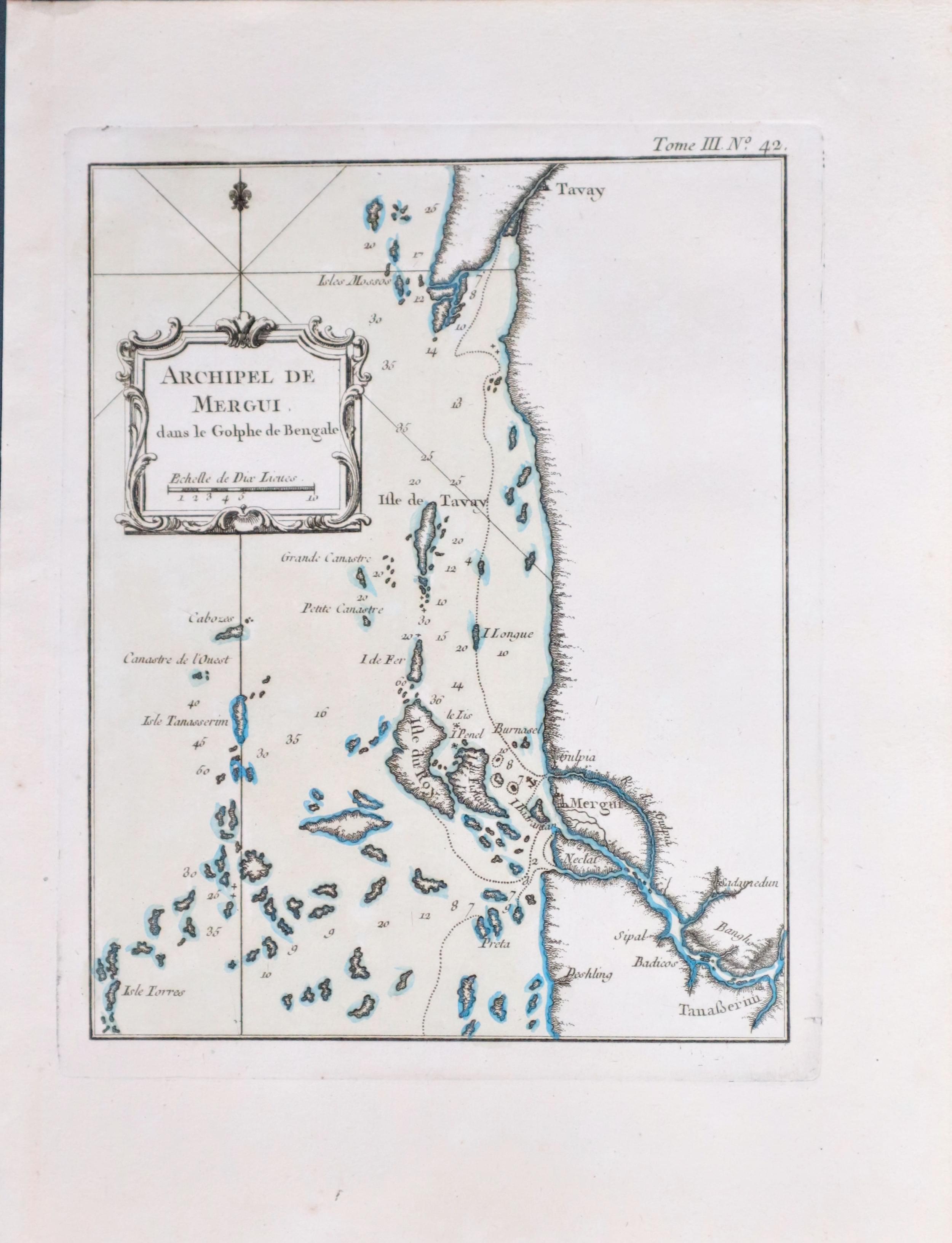
Merge Archipelago, Jacques Nicolas Bellin, 1764. Price: 65.00
ARCHIPEL DE MERGUI
An engraved chart of this remote region on the southern coast of Burma. Uncoloured rococo title cartouche which also displays the scale. 6 1/2 x 8 1/2 inches. Original outline and wash hand colouring. Fine clean condition. This map has come straight from the atlas and not previously been sold as a single map.
Map number 42 from Volume 3 of Le Petit Atlas Maritime
MOLUCCAS
18th Century
-

Molucca Islands, Jacques Nicolas Bellin, c.1760

29163 Molucca Islands, Jacques Nicolas Bellin, c.1760. Price: 25.00
CARTE PARTICULIERE DES ISLES MOLUQUES
An engraved map of the Moluques and also known as the Moluccan Islands or Maluka. Now part of Indonesia. The islands were once the part of the Dutch East Indies. 6 x 8 1/2 inches, 150 x 215 mm. Uncoloured. Worm hole in left hand side blank margin otherwise good clean condition.
THAILAND
18th Century - Early Hand Colouring
-

Lopburi, Thailand Jacques Nicolas Bellin, c.1760

32177 Lopburi, Jacques Nicolas Bellin, c.1764. Price: 95.00
PLAN DE LA VILLE DE LOUVO DEMEURE ORDINAIRE DES ROIS DE SIAM
An engraved town plan of Lopburi capital of the province with the same name in Thailand about 93 miles northeast of Bangkok. 6 3/4 x 8 1/2 inches. Original blue outline and wash hand colouring. Fine clean condition. Straight from the atlas and not previously sold as a single map.
Map number 69 from Volume 3 of Le Petit Atlas Maritime

RICHARD NICHOLSON
of CHESTER
Stoneydale
Pepper Street
Christleton
Chester
CH3 7AG
Telephone
01244 336004
International 44 1244 336004

I have been buying and selling antique maps since the early 1960's during which time I had a gallery in Watergate Street, Chester for 30 years. I am now able to offer through my websites a personal service to map and print collectors.

