Antique Maps of China & Tibet
Richard Nicholson of Chester

Established in 1961
A World of Antique Maps and Prints

The maps on this page are guaranteed to be genuine early specimens published in or around the year stated
CHINA
18th Century - Early Colouring
-

China, G Ribert de Vaugondy 1769

22400 China, G. Robert de Vaugondy, 1769. Price: 68.00
EMPIRE DE LA CHINE
Engraved map of China. Title panel dated 1769. 7 3/4 x 6 1/4 inches. Original out line hand colouring. Professional restoration to the left hand blank margin. Otherwise good condition.
From: Atlas Portatif Universal
17th Century
-

Xansi, Vincenzo Coronelli, c.1696

28719 Xansi, Vincenzo Coronelli, c.1696. Price: 320.00
XANSI, E XENSIS, PROVINCIE DELLA CHINE...
An engraved map of the region. A decorative title cartouche with coat of arms. Decorative scale cartouche and a third foliage cartouche with note. 23 1/2 x 17 3/4 inches, 600 x 450 mm. Uncoloured. Slit about 1/8 inch wide near centre fold with some loss in the desert area. Otherwise fine clean condition with good margins.
This map is one of Coronelli’s six maps showing the thirteen provinces of China, modelled on the earlier map by Joan Blaeu and the Jesuit Martino Martini.
From: Coronelli's Corso Geografico Universalle
17th Century
-

Iunan, Queicheu and Quangsi, Vincenzo Coronelli, c.1696

28720 Iunan, Queicheu and Quangsi, Vincenzo Coronelli, c.1696. Price: 380.00
IUNAN, QUEICHEU, E QUANGSI
An engraved map of the three provinces. Iunan (Yunnan), Queicheu (Guizhou) and Quangsi (Guangsi).Title within a large banner cartouche. Decorative scale cartouche. 23 1/2 x 17 3/4 inches, 600 x 450 mm. Uncoloured. Fine clean condition with good margins.
This map is one of Coronelli’s six maps showing the thirteen provinces of China, modelled on the earlier map by Joan Blaeu and the Jesuit Martino Martini.
From: Coronelli's Corso Geografico Universalle
17th Century
-

Chekiang and Kiangski, Vincenzo Coronelli, c.1696

30141 Chekiang and Kiangski, Vincenzo Coronelli, c.1696. Price: 380.00
CHEKIANG, E KIANSI, PROVINCIE DELLA CHINE...
An engraved map of this coastal region. A large decorative title cartouche with coat of arms. Decorative scale cartouche. 23 1/2 x 17 3/4 inches, 600 x 450 mm. Uncoloured. Fine clean condition with good margins.
This map is one of Coronelli’s six maps showing the thirteen provinces of China, modelled on the earlier map by Joan Blaeu and the Jesuit Martino Martini.
From: Coronelli's Corso Geografico Universalle
19th Century
-

China, George Frederick Cruchley, 1848

31523 China, George Frederick Cruchley, 1848. Price: 75.00
CHINA
A clearly engraved map of the country bearing the imprint February 1st 1842. Publishers rococo cartouche inscribed Cruchley’s Improved Atlas, for Schools & Families. 17 1/4 x 13 3/4 inches. Original outline and wash hand colouring. Small slit at the bottom of the centre fold. Some browning in the centre fold, otherwise good condition.
From: Cruchley’s General Atlas for the use of Schools and Private Tuition
19th Century
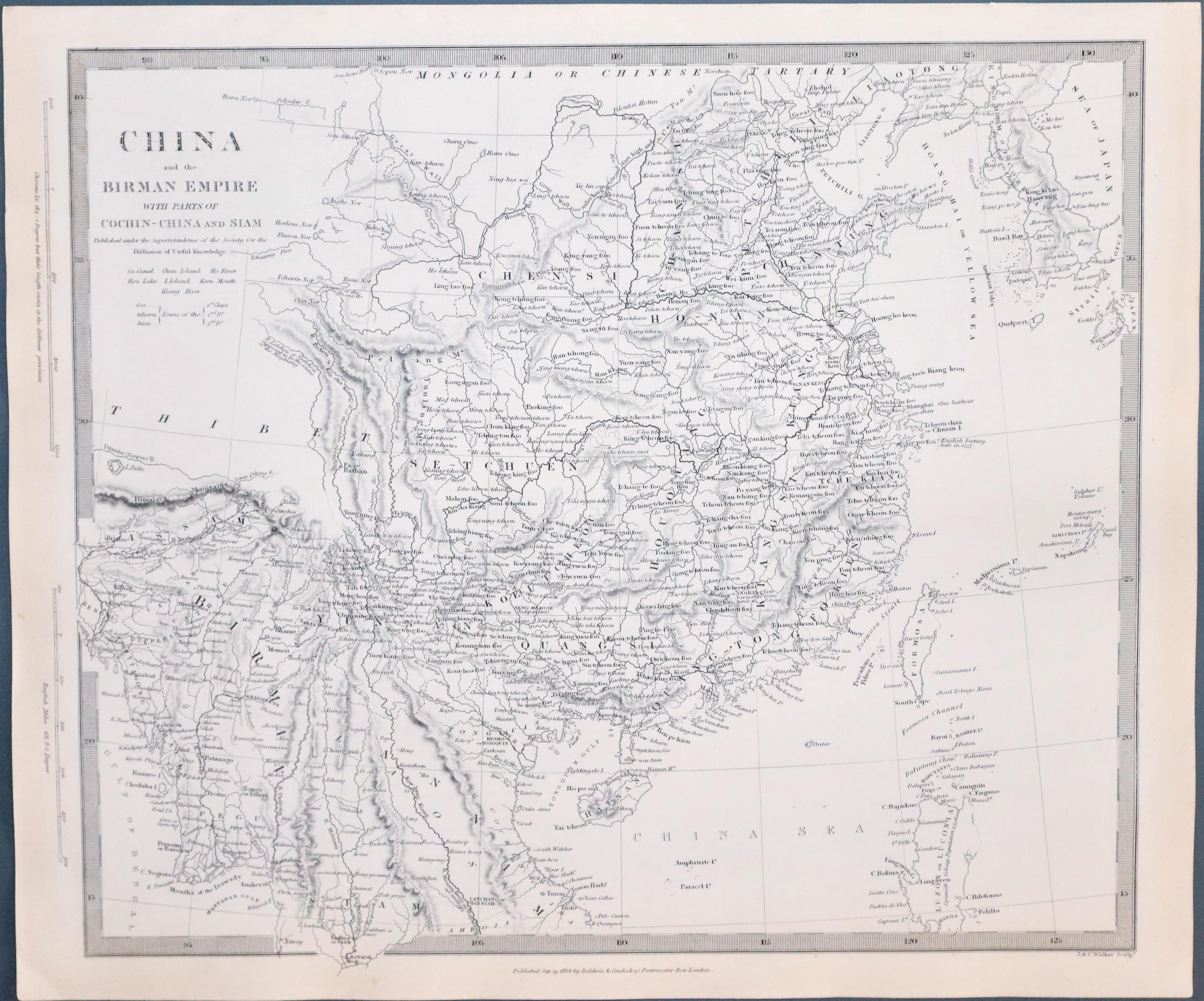
33397 China & the Birman Empire, S.D.U.K. c.1844. Price: 80.00
CHINA AND THE BIRMAN EMPIRE WITH PARTS OF COCHIN-CHINA AND SIAM
A detailed engraved map of the countries. Imprint of Baldwin & Craddock below dated 1834. 12 1/2 x 15 1/4 inches. Uncoloured. Plain on verso. Good condition. Straight from the atlas and not offered previously as a single map.
Published by Society for Diffusion of Useful Knowledge
19th Century
-

Map of China by S.D.U.K.
33398 China, S.D.U.K. c.1844. Price: 80.00
CHINA THE INTERIOR CHEFIN FROM DU HALDE AND THE JESUITS 1710 TO 1718
A detailed engraved map of the the whole of China. Imprint of Chapman & Hall below dated 1843. 12 1/4 x 15 1/2 inches. Uncoloured. Plain on verso. Good condition. Straight from the atlas and not offered previously as a single map.
Published by Society for Diffusion of Useful Knowledge
17th Century Text
-

China Text, Pieter van den Keere 1§668

22712 China Text, Pieter van den Keere, 1668. Price: 14.00
THE DESCRIPTION OF THE KINGDOM OF CHINA
Pages 189 to 196. The complete text to accompany the map of China from A Prospect of the Most Famous Parts of the World published by Roger Rea in 1668. Page size 6 1/2 x 4 inches. Good condition.
18th Century Text & Map
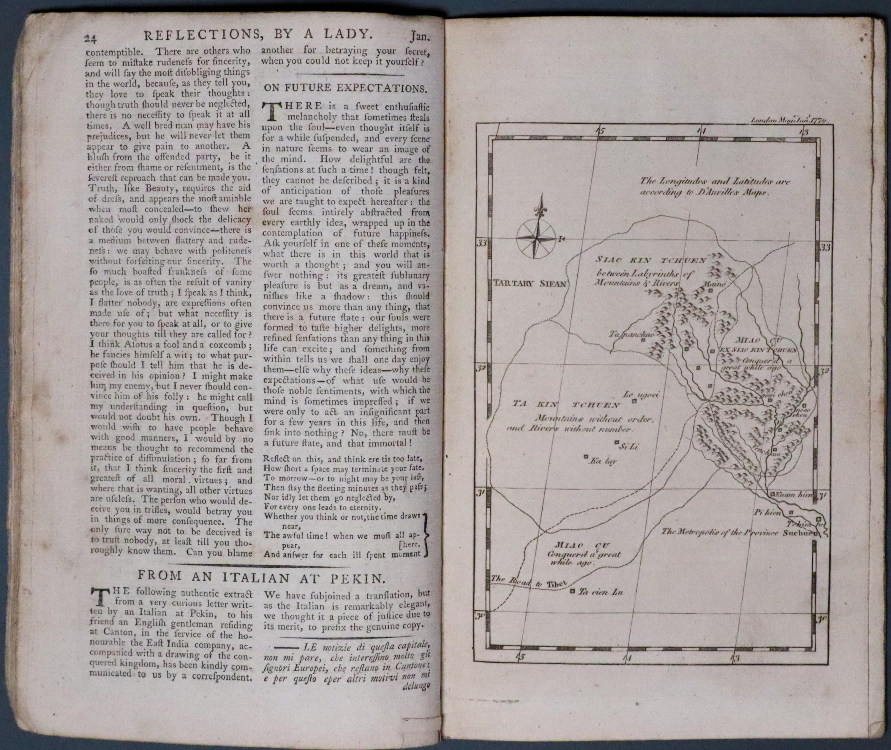
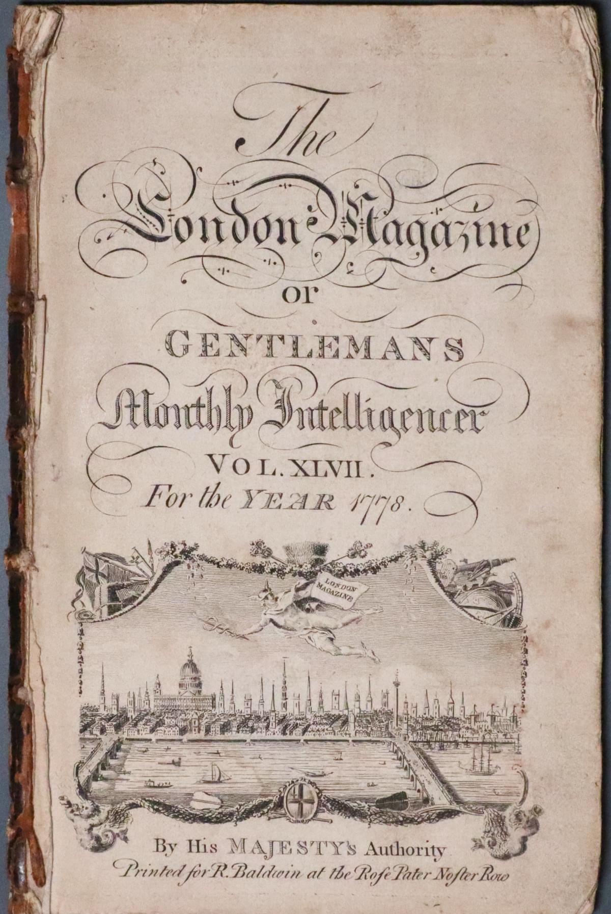
33716 Part of China, Thomas Kitchin, 1778. Price: 45.00
UNTITLED
A section from The London Magazine for 1778. Starting with the title page and running to page 48. Articles on The Glaciers in Switzerland, Censure and Praise, Female Virtue, Young Man of Fashion. At page 24 From an Italian at Pekin there is a full page map showing part of China with part of Sichuan. It indicates the road to Tibet. Compass pointer. 4 x 6 inches. Text continues with The Hypochondriack and The British Theatre.
Mid 18th Century
-

China, Emanuel Bowen, c.1747

33730 China, Emanuel Bowen, c.1747. Price: 125.00
A NEW & ACCURATE MAP OF CHINA DRAWN FROM SURVEYS MADE BY THE JESUIT MISSIONARIES BY ORDER OF THE EMPEROR. THE WHOLE BEING REGULATED BY NUMERPUS ASTRONOMICAL OBSERVATIONS. BY EMANUEL BOWEN
A good mid 18th century engraved map of the whole of China embellished with a pictorial title cartouche with figures. One of Bowen’s typical engraved notes in the left hand top corner. Original outline hand colouring. Traces of three original vertical folds. Light ink manuscript number of 421 in the top blank margin. Very light brown mark in the sea area and another darker one at the top of the map. My guess is that it might have been caused by candle grease. Professional repair in the bottom blank margin. 16 1/2 x 13 1/2 inches. A little light creasing but otherwise good condition.
From: A Complete System of Geography
Early 18th Century
-

China and Japan, Nicolas de Fer 1705

33731 China and Japan, Nicolas de Fer, 1705. Price: 200.00
LA PARTIE ORIENTALE DE L’ASIE OU SE TROUVENT LE GRAND EMPIRE DES TARTARES CHINOIS ET CELUY DU JAPON.. A fine engraved map which includes most of China with Japan based on information from Jesuit missionaries. Title panel dated 1705. Small compass rose. 13 x 9 inches. Uncoloured. Fine clean condition.
From L'Atlas Curieux.
TIBET
19th Century
-

Tibet, Mongolia & Manchuria, John Tallis c.1851

33732 Tibet, Mongolia & Manchuria, John Tallis, c.1851. Price: 95.00
THIBET, MONGOLIA, AND MANDCHOURIA
An engraved of the regions drrawn and engraved by J. Rapkin and published by John Tallis. The map is displayed within a patterned border and embellished with six uncoloured vignette views including Leh, Little Tibet; Chinese Wall; Fortress and Palace of Dala Lama, Lassa and Dwelling of Tessaling Lama. 12 3/4 x 9 3/4 inches, 325 x 245 mm. Imprint of John Tallis and Company beneath. Original centre fold. Original outline hand colouring. The map is in good condition free from any tears or repairs.
From: The Illustrated Atlas
18th Century
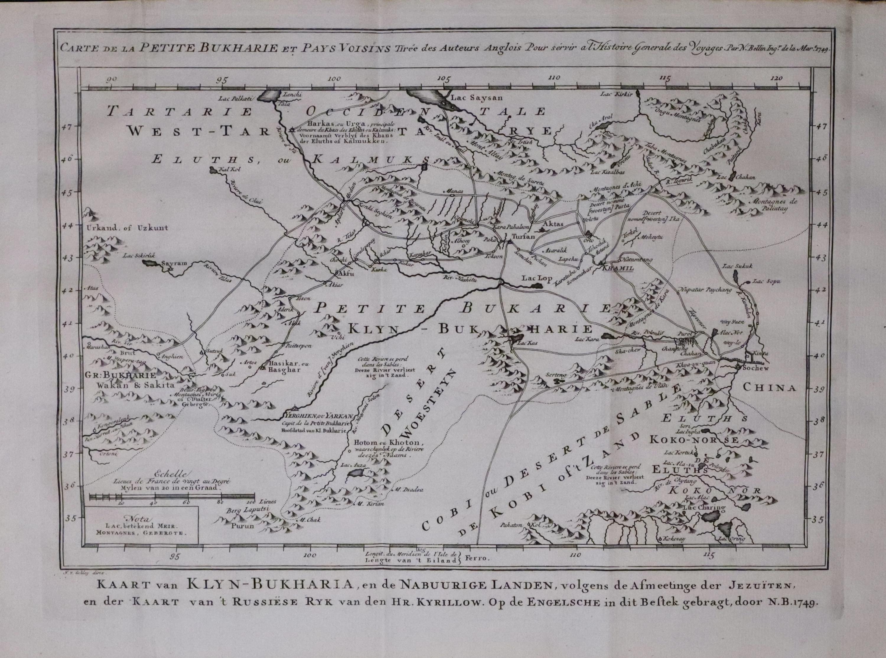
33733 Central Asia & China, J N Bellin / Jacob van der Schley, c.1758. Price: 68.00
CARTE DE LA PETITE BUKHARIE ET PAY VOISINS.....
An engraved map of Central Asia including Uzbekistan, Tajikistan, Turkmenistan and Kyrgyzstan along with the area of Xinjiang in north western China. Above the map is a French title and beneath a Dutch title. Uncoloured. Traces of three original vertical folding creases.12 x 8 1/2 inches. Uncoloured. Good condition.
From: The Dutch edition of Generale des Voyages, published in Paris 1746-1759
PRINTS
Circa 1780
A collection of copper engravings that appeared in Universe Displayed published circa 1780. Each print measures about 6 x 3 1/2 inches. Uncoloured. All in good clean undamaged condition unless otherwise dtates.
-

The Lowa or Fishing Bird of China

25470 The Low or Fishing Bird of China. c.1780. Price: 14.00
-

Begging Devotees of Cha & Jugglers mounted on tamed Tigers

25465 Begging Devotees of Cha & Jugglers mounted on tamed Tigers. c.1780. Price: 14.00
-

Chinese Jugglers, who pretend to sell the Wind

25468 Chinese Jugglers, who pretend to sell the Wind. c.1780. Price: 14.00
-

Magicians & Sorcerers of China

25467 Magicians & Sorcerers of China. Price: 14.00
-

A Chinese Triumphal Arch

25479 A Chinese Triumphal Arch. c.1780. Price: 14.00
-

A Curius Chinese Vessel called a Smake Boat

254678 A Curius Chinese Vessel called a Smake Boat. c.1780. Price: 14.00
-

Nankin the Captital City of China

25474 Nankin the Captital City of China. Price: 18.00
-

The Strange Mountains at Sangwanhab in China

25475 The Strange Mountains at Sangwanhab in China c.1780. Price: 10.00
Small rust spot in the left hand side blank margin
-

Chinese Women

25476 Chinese Women. c.1780. Price: 14.00


RICHARD NICHOLSON
of CHESTER
Stoneydale
Pepper Street
Christleton
Chester
CH3 7AG
Telephone
01244 336004
International 44 1244 336004

I have been buying and selling antique maps since the early 1960's during which time I had a gallery in Watergate Street, Chester for 30 years. I am now able to offer through my websites a personal service to map and print collectors.

