Antique Maps of Tuscany
Umbria, Venice and Verona
Richard Nicholson of Chester

Established in 1961
A World of Antique Maps and Prints

The maps on this page are guaranteed to be genuine early specimens published in or around the year stated
SAVOY
Savoy is a region of western Europe that emerged, along with the free communes of Switzerland, following the collapse of the Frankish Kingdom of Burgundy. Installed by Rudolph III, King of Burgundy, officially in 1003, the House of Savoy maintained independence as counts and then dukes until Savoia was linked with the Kingdom of Sardinia, which included Piemonte in north-western Italy. Savoy was largely absorbed into France in 1860, as part of the political agreement with Napoleon III that brought about the unification of Italy.
TUSCANY
18th Century Chart by an English Hydrographer
-

Cape Delle Melle to Mount Argentato, John Seller, c.1785.

32164 Cape Delle Melle to Mount Argentato, John Seller, c.1785. Price: 140.00
THE SEA COAST OF ITALY FROM CAPE DELLE MELLE TO MOUNT ARGRNTATO WITH THE ISLAND OF CORSICA
An interesting engraved chart by this English mapmaker. It shows the Gulf of Liguria with the islands of Corsica and Elba and a small piece of Sardinia. The coastline starts at Nice and carries on down the Tuscan coast. Decorative title cartouche and scales panel. Two compass roses and rhumb lines. 20 1/4 x 15 1/2 inches. Uncoloured. Centre fold as issued. Straight from the atlas and not previously sold as a single map. Tiny tear on the edge of the bottom margin otherwise good condition.
From: Part 3 of the English Pilot
Impressive 17th Century Map by Coronelli
-

Lucca, Tuscany map by V M Coronelli c.1696
32287 Lucca, Vincenzo Maria Coronelli, c.1696. Price: 230.00
REPUBLICA DI LUCCA, NELLA TOSCANA.......
An impressive large late 17th century map of the region of Lucca in Tuscany. Large title cartouche with with a banner supported by putti and coat of arms. A smaller cartouche displays the four scales. Ten coats of arms appear scattered across the map. Original centre fold. 23 3/4 x 17 1/2 inches. Uncoloured. 3 1/2 inch split at the bottom of the centre fold repaired otherwise the map is is good clean condition. Nice wide blank margins on the two sides.
From: Atlante Veneto
UMBRIA
Late 16th Century Map of Perugia
-

Perugia, Abraham Ortelius, c.1590
-

Test for Perugia by Abraham Ortelius


32214 Perugia, Abraham Ortelius, c.1595. Price: 290.00
PERUSINI AGRI EXACTISSIMA NOVISSIMAGUE DESCRIPTIO AUCTORE EGNATIO DANTE
A fine late 16th century engraved map centred on the city of Perugia in the Umbria region of Italy and showing Lake Thrasimene. The name of the cartographer Egnatio Dante appears within the decorative strapwork title cartouche. There is a small blank cartouche in the top left hand corner and in the bottom left corner a panel displaying the scale. The map is dated 1584 and comes from a Latin edition of Theatrum Orbis Terrarum published by Abraham Ortelius. 18 1/4 x 13 inches. Uncoloured. Latin text on verso. Superb clean condition.
From: Theatrum Orbis Terrarum
VENICE
Old Map of Rovigo in the 17th Century
-

Rovigo Italy, Jan Jansson, c.1690

23385 Rovigo, Jan Jansson, c.1690. Price: 220.00
POLESINO DI ROVIGO
An engraved map of the region around Rovigo, extending south to include Ferrara. The title and scale are displayed within two decorative uncoloured cartouches. 18 1/2 x 14 1/2 inches. Original outline hand colouring. Two small minor tears in the very wide bottom blank border, otherwise good.
18th Century - Sea Chart
-

Trimiti Isles, Joseph Roux, 1764

27921 Trimiti Isles, Joseph Roux, 1764. Price: 49.00
ISLES TRIMITI
A small engraved chart showing the islands of Caprera, St. Nicholas and Domino in the Gulf of Venice. Shows the depth soundings and anchorage points. 7 1/2 x 5 inches. Uncoloured. Good condition.
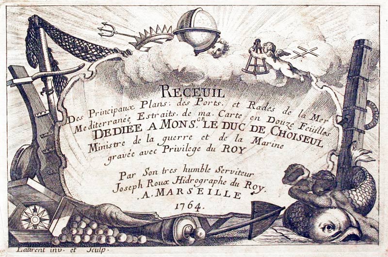
Plate 60 From: Receuil Des Principaux Plans; des Ports, et Rades de la Mer Mediterranée, Estraits, de ma. Carte Douze Feüilles.... Marselle 1764
Detailed Old Map of Lombardy & Venice
-

Lombardy and Venice, George Washington Bacon, 1891

30487 Lombardy and Venice, George Washington Bacon, 1891. Price: 18.00
ITALY LOMBARDY AND VENICE
A detailed colour printed map of the regions. 16 3/4 x 11 1/2 inches. Good blank margins. Good clean condition.
From: Complete Atlas of the World
19th Century
-

Venetia, James S.Virtue, c.1860

31558 Venetia, James S. Virtue, c.1860. Price: 19.00
VENETIA OR AUSTRIAN ITALY
A tinted lithograph map set within a decorative border. Original centre fold. 12 1/2 x 9 1/2 inches. Good clean condition.
Small 18th Century Chart of the River Po
-

Entrance to River Po, Joseph Roux 1764

27923 Entrance to the River Po, Jospeh Roux, 1764. Price: 45.00
UNTITLED
A small engraved chart showing the showing part of the Adriatic coast with the entrance to the River Po. Shows depth soundings, anchorage points and forts. 7 1/2 x 5 inches. Uncoloured. Good condition.
Plate 62 From Receuil Des Principaux Plans; des Ports, et Rades de la Mer Mediterranée, Estraits, de ma. Carte Douze Feüilles.... Marselle 1764
19th Century Town Plan
-

Venice, S.D.U.K. 1844

33753 Venice, S.D.U.K. 1844. Price: 260.00
VENICE - VENEZIA - VENEDIG
A fine detailed plan of Venice on two sheets. The left hand sheet has an uncoloured vignette vie of Piazza San Marco. Running across the base of both sheets are a total of 12 elevations of famous buildings indicating their respective heights. The right hand sheet bears an inset map of the Gulf of Venice on an unfurled scroll. Scales, key and a short descritive note on Venice. The engraved area on each sheet measures some 11 1/4 x 15 1/4 inches. Original green and blue hand colouring. A couple of light brownspots in the right hand sheet but otherwise good condition. Imprint of Charles Knight & Co.
From: Maps of the Society of the Diffusion of Useful Knowledge
VERONA
Verona, Mantua and Trento in the 16th Century
-

Verona, Abraham Ortelius, c.1590

30473 Verona, Abraham Ortelius, c.1581. Price: 280.00
VERONAE URBIS TERRITORIUM A BERNDO BROGNOLO DESCRIPTUM
An early engraved map of the region around Verona including Mantua and Trento. Large decorative title cartouche bearing an attribution to the cartographer Beernado Brognolio (1539-83) Scale with pair of dividers. Italian text on verso. Original centre fold. 18 1/2 x 13 inches. Attractive hand colouring. Traces of tape adhesion at top and bottom of the centre fold on verso where the map has once been in a mount. Some light crinkling. Otherwise good condition with full original wide blank margins.
From: Theatrum Orbis Terrarum
RICHARD NICHOLSON
of CHESTER
Stoneydale
Pepper Street
Christleton
Chester
CH3 7AG
Telephone
01244 336004
International 44 1244 336004

I have been buying and selling antique maps since the early 1960's during which time I had a gallery in Watergate Street, Chester for 30 years. I am now able to offer through my websites a personal service to map and print collectors.

