Antique Maps of Greece
Richard Nicholson of Chester

Established in 1961

The maps on this page are guaranteed to be genuine early specimens published in or around the year stated
Map of Turkey Europe 1822 with Early Hand Colouring
-

Turkey in Europe, Charles Smith, 1822

21649 Turkey in Europe, Charles Smith, 1822. Price: 43.00
TURKEY IN EUROPE
An engraved map extending from Bosnia and Moldavia in the north to Crete in the south. Title panel. Imprint dated 1820. 10 1/4 x 13 3/4 inches. Original outline and wash hand colouring. Fine condition.
From: Smith's New General Atlas
19th Century Turkey in Europe Map - Early Hand Colouring
-

Turkey in Europe, Conrad Malte-Brun, 1837

22356 Turkey in Europe, Conrad Malte-Brun, 1837. Price: 30.00
TURQUIE EUROPE 1834
An engraved map of the region with Greece. 8 3/4 x 12 inches. Original outline hand colouring. Wide blank margins. Good condition.
From: Atlas Complet du Precis de la Geographie Universelle. ed. J. J. Huet
Mid 17th Century Miniature Map of Greece
-

Greece by Pieter van den Keere 1666

22158 Greece, Peter van den Keere, 1666. Price: 60.00
GREECE
A miniature engraved map with title and scale cartouches. Part of a description of America on verso in English. 4 3/4 x 3 1/4 inches. Uncoloured. Good condition. Straight from the atlas and not previously sold as a single map.
From: A Prospect of the Most Famous Parts of the World published by Roger Rea.
The Ancient World
-

Ancient Greece and Crete, Guillaume de L'Isle c.1726

25249 Ancient Greece, Guillaume de L'Isle, c.1724. Price: 105.00
GRAECIAE PARS MERDIONALIS
An impressive engraved map of southern ancient Greece with theMorean Peninsula, Peloponnese and Aegean Islands Isles along with the island of Crete. It includes the ancient cities of Sparta, Athens and Corinth. Embellished with a large decorative pictorial title cartouche with figures. 25 1/2 x 18 1/2 inches. Original outline hand colouring. Short split at the bottom of the original centre fold. Small brown stain near the bottom of the centre fold in a blank sea area.
Nothern Greece - Ancient Times
-

Northern Greece in Ancient Times, G de L'Isle c.1726

25250 Norther Greece in Ancient Times, Guillaume deL'Isle c.1726. Price: 85.00
GRAECIAE PARS SEPTENTRIONALES
An most interesting engraved map of northern Greece in ancient times. Of particular interest to historians is the inclusion of the road system including the Via Egnatia being one of the most important routes of the Greek road system. The title appears within a panel across the base of the map with the name of Guillaume de l”Isle. In the top left hand corner is a panel showing two scales and the date of 1708. 25 1/2 x 18 1/2 inches. Some original outline hand colouring. Original centre fold. Some light water staining in all four corners. Small slit at the bottom of the centre fp;d. Two small tears at the top pf the centre fold in the blank border area.
19th Century Map of Turkey in Europe with Nice Early Wash Colouring
-

Turkey in Europe, John Dower, 1834

25633 Turkey in Europe, John Dower, 1834. Price: 39.00
TURKEY IN EUROPE
An engraved map extending from Belgrade to the island of Crete. 13 x 16 1/4 inches. Original outline and wash hand colouring. Fine condition. Paper watermarked J. Whatman 1834. Imprint of the publisher Henry Teesdale at 302 High Holborn, London. Small slit at one end of the centre fold otherwise nice bright condition.
From: A New General Atlas of the World
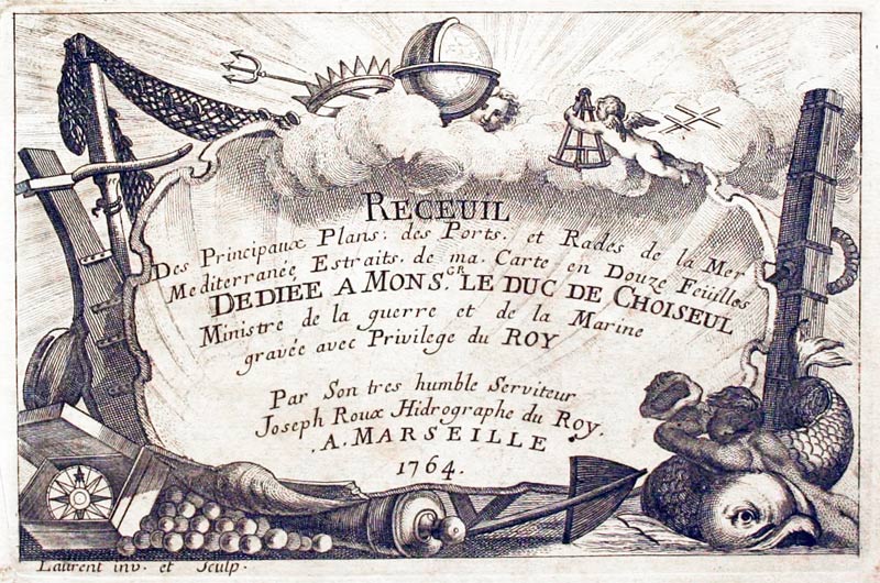
Small 18th Century Sea Chart of the Island of Servi
-

Island of Servi, Greece, Joseph Roux 1764

27940 Servi, Joseph Roux, 1764. Price: 45.00
MORÉE
A small engraved chart showing the island of Servi lying off the Peloponnese coast. Shows the soundings, anchorage point. 7 1/2 x 5 inches. Uncoloured. Good condition.
Plate 79 From Receuil Des Principaux Plans; des Ports, et Rades de la Mer Mediterranée, Estraits, de ma. Carte Douze Feüilles.... Marselle 1764
Small 18th Century Sea Chart of part of the Island of Kythira
-

Port St. Nicolo, Kythira, Joseph Roux 1764

27941 Kythira, Joseph Roux, 1764. Price: 45.00
PORT ST. NICOLO SURE L'ISLE SERIGO
A small engraved chart of Avlemonas Bay, Kythira or Cythera. An island formerly Cerigo that lies opposite the south eastern tip of the Peloponese peninsula. 7 1/2 x 5 inches. Uncoloured. Good condition.
Plate 80 From: Receuil Des Principaux Plans; des Ports, et Rades de la Mer Mediterranée, Estraits, de ma. Carte Douze Feüilles.... Marselle 1764
Interesting 18th Century Chart of Piraeus, Athens
-

Port Oiraeus, Athens, Joseph Roux 1764

27945 Piraeus, Joseph Roux, 1764. Price: 48.00
PORT LION AUTREFOIS PORT D’ATHENS
An interesting small engraved chart showing the Greek port of Piraeus situated near to Athens. Shows depth soundings. Rhum lines from a compass pointer. 7 1/2 x 5 inches. Uncoloured. Good condition.
Plate 84 From Receuil Des Principaux Plans; des Ports, et Rades de la Mer Mediterranée, Estraits, de ma. Carte Douze Feüilles.... Marselle 1764
18th Century Sea Chart by Joseph Roux
-

Mandry - Greece, Joseph Roux, 1764

27946 Mandry, Joseph Roux, 1764. Price: 35.00
PLAN DE LA MANDRY
A small engraved chart of the bay with depth soundings.. 7 1/2 x 5 inches. Uncoloured. Good condition.
Plate 82 From: Receuil Des Principaux Plans; des Ports, et Rades de la Mer Mediterranée, Estraits, de ma. Carte Douze Feüilles.... Marselle 1764
18th Century Sea Chart of the Island of Astypalea
-

Astypalea - Greece, Joseph Roux, 1764

27968 Astypalea, Joseph Roux, 1764. Price: 36.00
ISLE ESTAMPALIE
A small engraved chart of the island of Astypalae in Greece. Part of the Dodecanese island group. 7 3/4 x 5 inches. Uncoloured. ScaleSmall light brown foxing mark but other goodf condition. Straight from the atlas and not previously sold as a single map..
Plate 109. From Receuil Des Principaux Plans; des Ports, et Rades de la Mer Mediterranée, Estraits, de ma. Carte Douze Feüilles.... Marselle 1764
18th Century - Sea Chart
-

Ispera - Greece, Joseph Roux, 1764

27970 Ispera, Joseph Roux, 1764. Price: 35.00
ISLE IPSERA
A small engraved chart showing part of the island of Ipsera and the small island of Antipsara, part of the Dodecanese island group in the southeatsern Aegean Sea. 7 1/2 x 5 inches. Uncoloured. Good condition. Straight from the atlas and not previously sold as a single map. Plate 107. From Receuil Des Principaux Plans; des Ports, et Rades de la Mer Mediterranée, Estraits, de ma. Carte Douze Feüilles.... Marselle 1764
18th Century - Sea Chart
-

Lemnos, Joseph Roux, 1764

27977 Lemnos, Joseph Roux, 1764. Price: 46.00
PORT ST. ANTOPINE SUR L’ISLE DE LEMNOS
A small engraved chart. Shows the soundings and anchorage points . 7 3/4 x 5 inches. Uncoloured. Good condition. Plate 100
From: Receuil Des Principaux Plans; des Ports, et Rades de la Mer Mediterranée, Estraits, de ma. Carte Douze Feüilles.... Marselle 1764
18th Century - Sea Chart
-

Gulf of Kassandra, Greece, Joseph Roux, 1764

27980 Gulf of Kasandra Joseph Roux, 1764. Price: 36.00
GOLPHE DE CASSANDRE
A small engraved chart of this region of Greece. It shows depth soundings and anchorage points. 7 1/2 x 5 inches. Uncoloured. Good condition.
Plate 97 From Receuil Des Principaux Plans; des Ports, et Rades de la Mer Mediterranée, Estraits, de ma. Carte Douze Feüilles.... Marselle 1764
Late 17th Century - Elaborate
-

Map of Athens by Vincenzo Coronelli c.1695
28079 Athens, Vincenzo Maria Coronelli, c.1695. Price: 680.00
PIANTA DELLA CITTA FORTEZZA D’ATNE
A fascinating engraved map of Athens during the Classical period set within a wide elaborate decorative border displaying fruit and flowers. The map is centred on the Acropolis. To the right is a panel with two coats of arms listing using a key of letters the important places on the map. 24 x 17 3/4 inches. Uncoloured. Original centre fold. 1 1/2 inch split at the bottom of the centre fold with the lost of a small piece of the bottom blank margin. Some very light foxing evident in the right hand blank margin. A little light creasing otherwise good clean condition.
Early Engraving of Mount Olympus
-

Tempe, Abraham Ortelius, 1601

28730 Tempe, Abraham Ortelius, 1601. Price: 400.00
TEMPE
An early engraved map showing Mount Olympus and the valley called the Vale of Tempe in ancient times situated in northern Thessaley, Greece. The river Peneus runs though the valley the present day name being Salambria. 18 1/2 x 14 1/4 inches. Original uncoloured state. Fine clean conditon with wide blank margins. Latin text on verso.
This map comes from the Parergon Theatri which appeared as a historical section of Ortelius’ Theatrum or sometimes as a separate publication.
19th Century - Early Hand Colouring
-

Turkey in Europe, Robert Wilkinson, 1800

29499 Turkey in Europe, Robert Wilkinson, 1800. Price: 46.00
TURKEY IN EUROPE DRAWN FROM MANY ASTRONOMICAL OBSERVATIONS AND SURVEYS
A map by E. Bourne including Bosnia, Serbia, Romania, Albania, Greece and Crete. The imprint of the published Robert Wilkinson appears beneath the map dated 1800. 8 1/2 x 11 inches. Original outline and wash hand colouring. Good stout paper. Manuscript number 36 in blank margin. Good clean condition with no repairs. A nice specimen.
From: A General Atlas being A Collection of Maps of the World and Quarters the Principal Empires, Kingdoms &c, with their several Provinces & other Subdivisions, Correctly Delineated
19th Century - Early Hand Colouring
-

Turkey in Europe, Joseph de Laporte, 1793

30651 Turkey in Europe, Joseph de Laporte, 1793. Price: 26.00
LE ROYAUME DE HONGRIE ET LA TURQUIE D’EUROPE
An engraved map with decorative title cartouche. 8 1/2 x 6 3/4 inches. Some original green outline hand colouring. Good condition.
From: Atlas Moderne Portatif
19th Century - Early Hand Colouring
-

Turkey in Europe, Conrad Malte-Brun.1837

31463 Turkey in Europe, Conrad Malte-Brun.1837. Price: 23.00
TURQUIE EUROPE 1834
An engraved map of the region with Greece. 8 3/4 x 12 inches. Original outline hand colouring. Single printer’s crease in the bottom left hand side otherwise good condition.
From: Atlas Complet du Precis de la Geographie Universelle. ed. J. J. Huet.
18th Century
-

Macedonia and Thessaly, Philipp Cluver 1727

31678 Macedonia and Thessaly, Philip Cluver, 1729. Price: 49.00
MACEDONIAE ET THESSALIAE REGIONES
An engraved map of northern Greece showing the historical areas of Macedonia and Thesalia. Embellished with a decorative pictorial cartouche with figures. 9 3/4 x 7 1/2 inches. Line around the map where it has been in a sunk mount at some time. Original centre fold. Hand coloured. Traces of brown tape on the edges of verso where the map has been attached to a mount. Otherwise good condition with no tears or repairs.
From: Introductionis in Universam Geographiam...
Ancient Geography
-

Map of Ancient Greece by Conrad Malte-Brun

32140 Ancient Greece, Conrad Malte-Brun, 1829. Price: 29.00
GRECE ANCIEN
An engraved map of Greece including Crete in ancient times. Architectural title cartouche. 11 x 8 inches. Original outline hand colouring. Good condition. From Atlas Complet du PrÄcis de la GÄographie Universelle...
17th Century - Sea Chart
-

Island of Kythira and Gulf, Greece Pieter Goos 1667

32264 Gulf of Laconia and Cythera, Pieter Goos, 1667. Price: 120.00
Pascaerte van Zuy delycste zeecusten van MOREA Tusschen Sapienza ende C. de Angelo en de Eylanden daer omtrent gelegen
A fine engraved chart orientated with north north west at the top showing the Gulf of Laconia with Cape Tainaron and Cape Maleas plus the island of Cythera or Kythira. Decorative title cartouche. Sailing ship, compass rose and rhumb lines. 20 3/4 x 15 1/2 inches. Uncoloured. Fine clean condition with good blank margins.
17th Century
-

Greece by John Speed 1646
-

Text on verso of map of Greece by John Speed 1646


32846 Greece, John Speed, 1650. Price: 400.00
GREECE
An engraved 17th century map of the country embellished with decorative title and scale cartouches. Ships and sea monsters. Imprint of the publisher George Humble and the date of 1626. Original centre fold. Description of Greece in English on verso. Uncoloured. 19 3/4x 15 1/4 inches. Very light water staining across the two bottom corner. Small nick in left hand blank margin. Otherwise a nice clean crisp specimen that has just been taken from the atlas and there not been previously sold as a single map.
From: Prospect of the Most Famous Parts of the World
18th Century
-

Ancient Greece, Edward Wells 1700

33340 Ancient Greece, Edward Wells, 1700. Price: 50.00
A NEW MAP ON ANTIENT THRACE AS ALSO OF THE NORTHERN PARTS OF OLD GREECE, VIZ. MACEDONIA AND THESALIA. DEDICATED TO HIS HIGHNESS WILLIAM DUKE OF GLOUCESTER
An interesting engraved map of the region in ancient times. Decorative title cartouche surmounted by the royal arms. 19 x 14 inches. Uncoloured. Original centre fold. Light waters tain. Lightly tones. Tear in the top right hand corner repaired. Otherwise good.
16th Century
-

Island of Milos, Tomaso Poracchi c.1580

33341 Milos, Tomaso Porcacchi, c.1580. Price: 98.00
MILO
A small early engraved map of the island of Milos situated in the southern part of the Cyclades islands. The map is embellished with a decorative title cartouche, compass rose and three sea monsters. 5 1/2 x 4 inches, 140 x 100 mm. Underneath is a decorative initial letter A followed by Italian text which continues onto the reverse side. Page numbered 121 / 122 Uncoloured. Good condition.
From: L'Isole del Mondo
Greece & Aegean in Ancient Times
-

Greece & Aegean in Ancient Times, Dr. Henry Kiepert

33445 Greece & Aegean, Dr. Henry Kiepert, c.1902. Price: 24.00
GRAECIA CUM INSULIS ET ORIS MARIS AEGAEIA
A lithograph map of Greece and the Islands in ancient times. Inset map. 17 1/4 x 13 1/2 inches. Original centre fold. Good condition.
From: Atlas Antiquus published in Berlin
Greece in Ancient Times
-

Greece in Ancient Times, Dr. Henry Kiepert

33446 Greece, Dr. Henry Kiepert, c.1902. Price: 20.00
GRAECIA
A lithograph map of Greece in ancient times. Two inset maps. 13 1/4 x 16 3/4 inches. Original centre fold. Good condition.
From: Atlas Antiquus published in Berlin
Early 19th Century
-

Turkey in Europe, John Russell, 1800

26493 Turkey in Europe, John Russell, 1800. Price: 32.00
TURKEY IN EUROPE, AND HUNGARY. DRAWN FROM THE BEST AUTHORITIES, BY J. RUSSELL
An engraved map of Hungary, Transylvania and Greece with the island of Crete. 18 x 15 1/2 inches. Original outline hand colouring. Small slit at the bottom of the centre fold and a small tear in the bottom blank margin. Otherwise a nice clean specimen.
From:The Atlas to Guthrie’s System of Geography. Engraved for G. G. and J. Robinson, Pater-noster Row, and J. Mawman (Succesor to Mr. Dilly), Poultry. S. Hamilton, Printer, Falcon-court, Fleet Street. Price of the atlas when published half bound was one guinea.
17th Century - Ancient
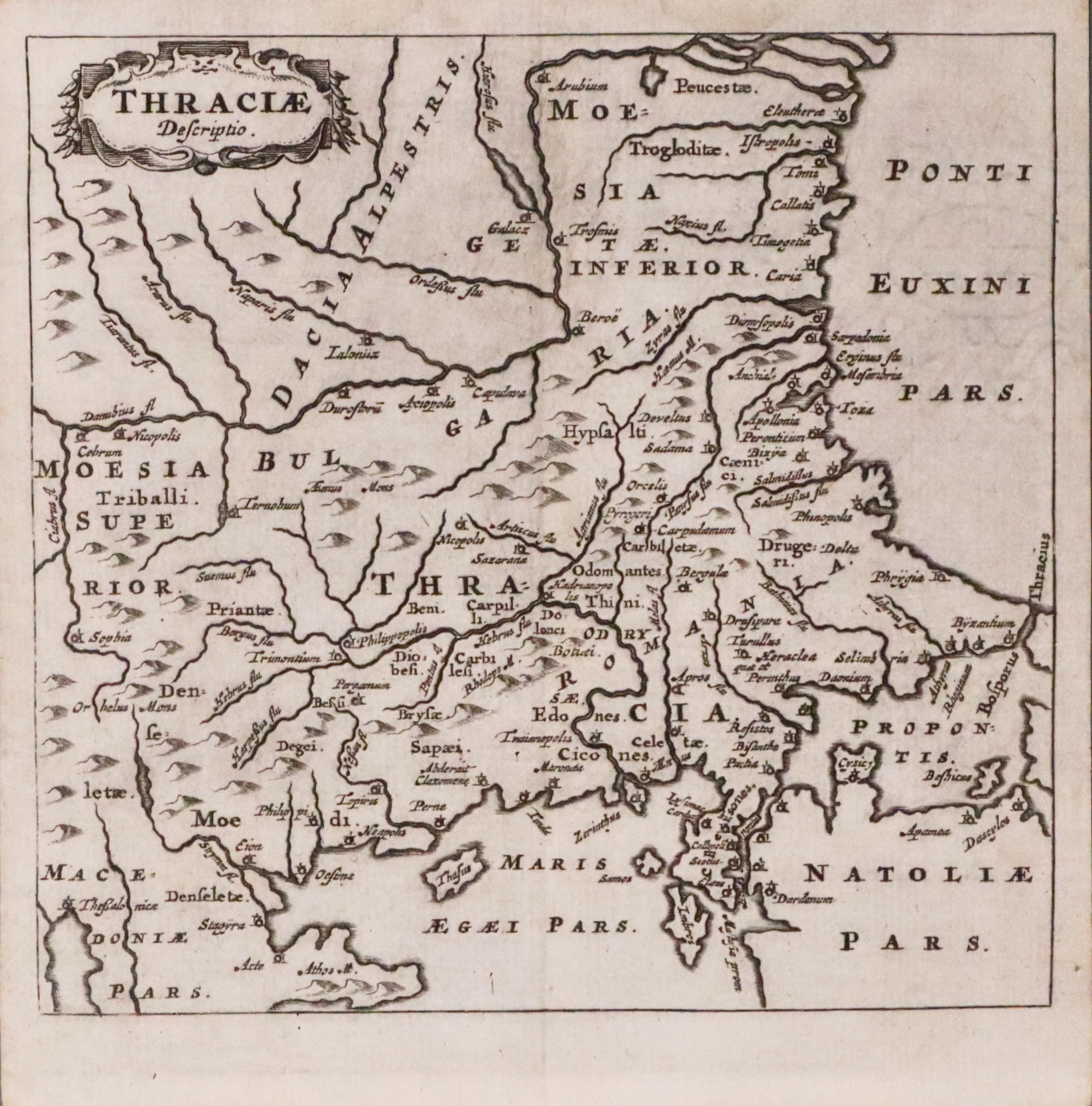
32163 Thrace, Philipp Cluver, 1686. Price: 28.00
THRACIAE DESCRIPTIO
A small engraved map of Thracia or Thrace. The ancient name given to this region of the south eastern Balkans. Present day Moldova, Romania, Turkey and Greece. Decorative title cartouche. 4 3/4 x 4 1/2 inches. Original centre fold. Uncoloured. Fine clean condition.
18th Century
-

Turkey in Europe by Thomas Kitchin

33649 Turkey in Europe, Thomas Kitchin 1782. Price: 27.00
HUNGARY &C WITH TURKY IN EUROPE
An engraved map of the region with a pictorial title cartouche. In the blank margin below is the name of Thomas Kitchin. 8 1/2 x 6 3/4 inches. Uncoloured. A little light offsetting. traces of two original vertical folds. Small split at the bottom of one. Uncoloured. Clean condition.
From: Guthrie's New Geographical, Historical & Commercial Grammar
Voyage of Aeneas
-

Voyage of Aeneas, John Knapton 1757

33660 Voyage of Aeneas, John Knapton, 1757. Price: 29.00
THE VOYAGE OF AENEAS AS DESCRIBED BY VIRGIL
An interesting engraved maps illustrating the Ancient World. It shows part of the Mediterranean showing the path of the voyage with part of Italy, Sicily, part of Greece and Crete. Title panel. 9 x 6 1/4 inches. Uncoloured. Clean onditin with wide blank margins. A little light creasing in the bottom right hand blank margin corner.
From: Geographia Classica: The Geography of the Antients So far described as is contained in the Greek and Latin Classicks in Twenty-Nine Maps of the Old World, and its several Kingdoms and Provinces.....Printed for John Knapton, in Ludgate Street, 1757.

RICHARD NICHOLSON
of CHESTER
Stoneydale
Pepper Street
Christleton
Chester
CH3 7AG
Telephone
01244 336004
International 44 1244 336004

I have been buying and selling antique maps since the early 1960's during which time I had a gallery in Watergate Street, Chester for 30 years. I am now able to offer through my websites a personal service to map and print collectors.

