British Isles Maps pre 1800
Richard Nicholson of Chester

Established in 1961
A World of Antique Maps and Prints

The maps on this page are guaranteed to be genuine early specimens published in or around the year stated
18th Century - Early Hand Colouring
-

The English Channel, R. & J. Ottens, c.1750

21417 The English Channel, R & J. Ottens, c.1750. Price: 350.00
LA PLUS GRANDE PARTIE DE LA MANCHE...
A fine engraved map showing the south east corner of England as far north as Colchester and as far west as Lulworth in Dorset and Gloucester. Part of the continental coast is shown with the island of Alderney. The title, scales and explanation appear across the top of the map. 23.25 x 19 inches. Fine original outline and wash hand colouring. Good condition.
18th Century - Early Hand Colouring
-

Central England, von Reilly 1789

24040 Central England, Franz Joseph von Reilly, 1789. Price: 68.00
Des Konigreichs ENGLAND westlicher Theil, oder Hereford Shire, Worcester Sh, Warwick Shire, Nordhampton Shire, Rutland Shire, Leicester Shire, Linkoln Shire, Notingham Shire, Derby Shire, Stafford Shire, Shrop Sh. und Sheshire Nro. 82
An engraved map of central England divided into counties. Uncoloured title cartouche. 10 3/4 x 8 inches. Early wash hand colouring. Good condition. Straight from the atlas and not sold as a single map before.
From: Schauplatz der funf Theile der Welt
18th Century - Early Hand Colouring
-

Northern England, von Reilly 1789

24041 Northern England, Franz Joseph von Reilly, 1789. Price: 68.00
Des Konigreichs ENGLAND nordlicker Theil oder York Shire, das Bithum Durham, Northumberland, Cumerland, Westmoreland, und Lancashire. Nro. 83
An engraved map of northern England embellished with a decorative uncoloured title cartouche. 10 3/4 x 8 1/4 inches. Early wash hand colouring. Slight vertical crease on the left hand side otherwise good condition.
From: Schauplatz der funf Theile der Welt
18th Century - Sea Chart
-

East Coast and North Sea, Captain Greenville Collins, c.1745

29259 East Coast and North Sea, Captain Greenville Collins, c.1745. Price: 300.00
An interesting untitled chart orientated with west at the top. The east coast of England is shown from Berwick to just west of Rye in Sussex. Arms of England. Continental coast from Holland to Calais. Decorative dedication cartouche with figures. Compass rose and rhumb lines. 21 x 17 inches, 550 x 440 mm. Fine hand colouring. Some light toning. Nice heavy paper. No tears or repairs.
From: Coasting Pilot
18th Century - Sea Chart
-

St. George's Channel, Captain Greenville Collins, c.1760

31028 St. George's Channel Captain Greenville Collins, c.1760. Price: 250.00
ST. GEORGE'S CHANNEL
An untitled chart orientated with west the at the top. Includes the coast of Ireland from Belfast to Cork and the coastline of England and Wales from the Mull of Galloway to the Lizard in Cornwall. Embellished with a cartouche bearing a dedication to Sir Richard Rooth, Knt.Late Governor of their Mahies Fort Castl-ny-Park near Kinsale. 22 3/4 x 18 inches. Uncoloured. Lightly toned but good condition with no tears or repairs.
From: Great Britains Coasting Pilot
18th Century
-

Enland and Wales Counties, T. Badeslade and W. H.Toms 1742

31077 England and Wales Counties, Thomas Badeslade and William Henry Toms, 1742. Price: 33.00
ENGLAND
An interesting small engraved map of England and Wales divided into counties. Title panel. List of counties with a table showing their length, breadth and area. 5 3/4 x 5 1/2 inches. Uncoloured. Publisher’s imprint beneath dated 1742 with the names of Thomas Badeslade the surveyor and W. H. Toms the engraver Very nice good clean condition.
From: Chorographia Britanniae
Provenance: In 1925 the atlas was owned by A. P. Hamilton
18th Century
-

North West England, Pieter van der Aa c.1720

31650 North West England and North Wales, Pieter van der Aa, c.1720. Price: 55.00
LES COMTES DE SHROPS, LANCASTRE, CHESTER, CARDIGAN, RADNOR, MONGOMERY, MERIONETH, CAENRVAN, DENBIGH, FLINT ET AUTRES
An engraved map after Mercator showing the north west of England with part of Wales, part of the coast of Ireland and part of the Isle of Man. Hand coloured. 7 3/4 x 5 3/4 inches. A little light creasing but otherwise good undamaged condition.
Pieter van der Aa was one of a small group of European cartographers who produced a series of county maps of England
Early 17th Century
-

Saxon Heptarchy map by William Hole 1637

33024 England and Wales - Saxon Heptarchy, William Hole, 1637. Price: 185.00
ENGLADOND ANGLIS ANGLOSAXONUM HEPTARCHIA
An early engraved map depicting England and Wales showing the ancient kingdoms during Saxon Heptarchy. Decorative title cartouche, scale panel, compass rose and ships. Engraved by William Hole who name appears by the scale cartouche. Number 1 in bottom left hand corner. 12 1/2 x 10 3/4 inches. Uncoloured. Original centre fold. Plain on verso with manuscript list John Higham 1734, Charles Higham and Ch... Higham. A little light browning in the top left and right blank margins. A little light creasing in the centre fold otherwise good undamaged condition.
From: Camden’s Britannia
18th Century
-

British Isles text by William Camden 1637

33237 England and Wales, Jospeh Ellis, c.1777. Price 40.00
AN ACCURATE MODERN MAP OF ENGLAND AND WALES DRAWN FROM THE LATEST SURVEYS CORRECTED & IMPROVED BY THE BEST AUTHORITIES. Printed for Robert Sayer at the Golden Buck in Fleet Street and Carington Bowles next the Chapter House in St. Pauls Church Yard
An engraved map of England and Wales divided into counties. The title is displayed within a decorative pictorial cartouche. 15 3/4 x 18 1/4 inches. This map appears folded in the atlas and therefore is usually found as with this specimen as not having a complete blank border. Original fold creases. Some of these fold are strengthened on verso.. Uncoloured. Some traces of browning on verso from tape in the past. Clean condition.
From: Ellis's English Atlas or a Compleat Chorography of England and Wales in 50 Maps.
17th Century - Early Hand Colouring
-

Saxon Heptarchy, John Speed c.1627
-

Back of old frame


20287 Saxon Heptarchy, John Speed, c.1627. Price: 1,900
BRITAIN AS IT WAS DEVIDED IN THE TYME OF THE ENGLISHE SAXONS ESPECIALLY DURING THEIR HEPTARCHY
An interesting specimen of this map England, Wales and Scotland showing the Saxon Kingdoms. Title cartouche. Down the two sides of the map are two wide borders with a total of fourteen oval panels. On the left the panels display engravings of seven Saxon kings whilst on the right are seven ovals panels with scenes illustrating the conversion of the kings to Christianity. 20 x 15 inches. Early hand hand colouring. Presented in an ivory tint sunk mount with lines and wash plus a hand written title “Drawn - engraved and published about 1610 (b - 1542) John Speed (d- 1629) Antiquarian & Historian Author of ‘A History of Britaine’ Framed many years ago in a 3/4 inch black and gilt hogarth moulding which is still in good condition.
I have not examined this map outside of the frame so it is sold as seen.
ONLY AVAILABLE BY COLLECTION FROM CHRISTLETON
18th Century - First Edition
-

Saxon Britain, Robert Morden 1695

33477 Saxon Britain, Robert Morden 1695. Price: 48.00
BRITANNIA SAXONICA
An interesting engraved map of England and Wales in Saxon times. Engraved by John Sturt for Robert Morden. The Saxon counties are shown with the Saxon names for towns and villages along with battle sites. Two decorative cartouches. Small ships. 12 x 14 inches, 295 x 370 mm. Original centre fold. Uncoloured. Small repair to corner of one large blank border and a small hole in the area of Lincolnshire with the lose of one place name, otherwise good condition. This map has been taken straight from the atlas and therefore not previously offered for sale as a single map.
From: Camden's Britannia
16th Century
-

British Isles by Sebastian Munster c.1570

33538 British Isles, Sebastian Munster c.1570. Price: 90.00
A simple woodcut map of the British Isles divided into Scotia, Wallia, Anglia, Corneuall and Hibernia. City of Edinburgh is shown in Scotland. In England London, Oxford and Dover are shown and in Ireland Waterford is shown. The map measures 5 1/4 x 3 1/8 inches set within a page of German text. There is also German text on verso. Good condition.
From: Munster’s Cosmographia
Roads of England, Wales & Scotland - Folding
-

Roads of England and Scotland, Laurie & Whittle 1800
-

Slip Case for Roads of England and Scotland, Laurie & Whittle 1800


33559 England, Wales & Scotland - Roads, Laurie & Whittle 1800. Price: 200.00
A NEW MAP OF THE ROADS OF ENGLAND AND SCOTLAND WITH THE DISTANCES IN MEASURED MILES FROM PLACE TO PLACE IN WHICH HAVE BEEN ADDED THE PRINCIPAL POST-ROADS OF THE NORTH-WEST PART OF FRANCE, AS FAR AS PARIS, ECA
A nice specimen of this folding engraved map being the imprint of Laurie & Whittle date 1800 within an uncoloured cartouche. The far north of Scotland is shown as an inset map. Dissected into 24 section and mounted on linen. The map is in nice clean condition with no tears or repairs. With it is the original titled slipcase which is worn.
Early 17th Century
-

South East Egland, Gerard Mercator, 1623
-

French text on verso of South East Egland, Gerard Mercator, 1623


33634 South East England, Gerard Mercator, 1623. Price: 155.00
WARWICUM, NORTHHAMTONIA, HUNTINGDONIA, CANTABRIGIA, SUFFOLCIA, OXONIUM, BUCKINGHAMIA, BEDFORDIA, HARTFORDIA, ESSEXIA, BERCERIA, MIDDELSEXIA, SOUTHHATONIA, SURRIA, CANTIU & SOUTHSEXIA
An early engraved map of south east England embellished with a decorative title cartouche. 18 1/4 x 14 1/4 inches. French text on verso. Later hand colouring. Good sized blank margins. Lightly toned. Original centre fold. Small slit at the top of the centre fold in the margin. Small repairs on verso to the top and bottom of the centre fold in the blank margin area. Otherwise good condition.
Important Map for the Serious Collector
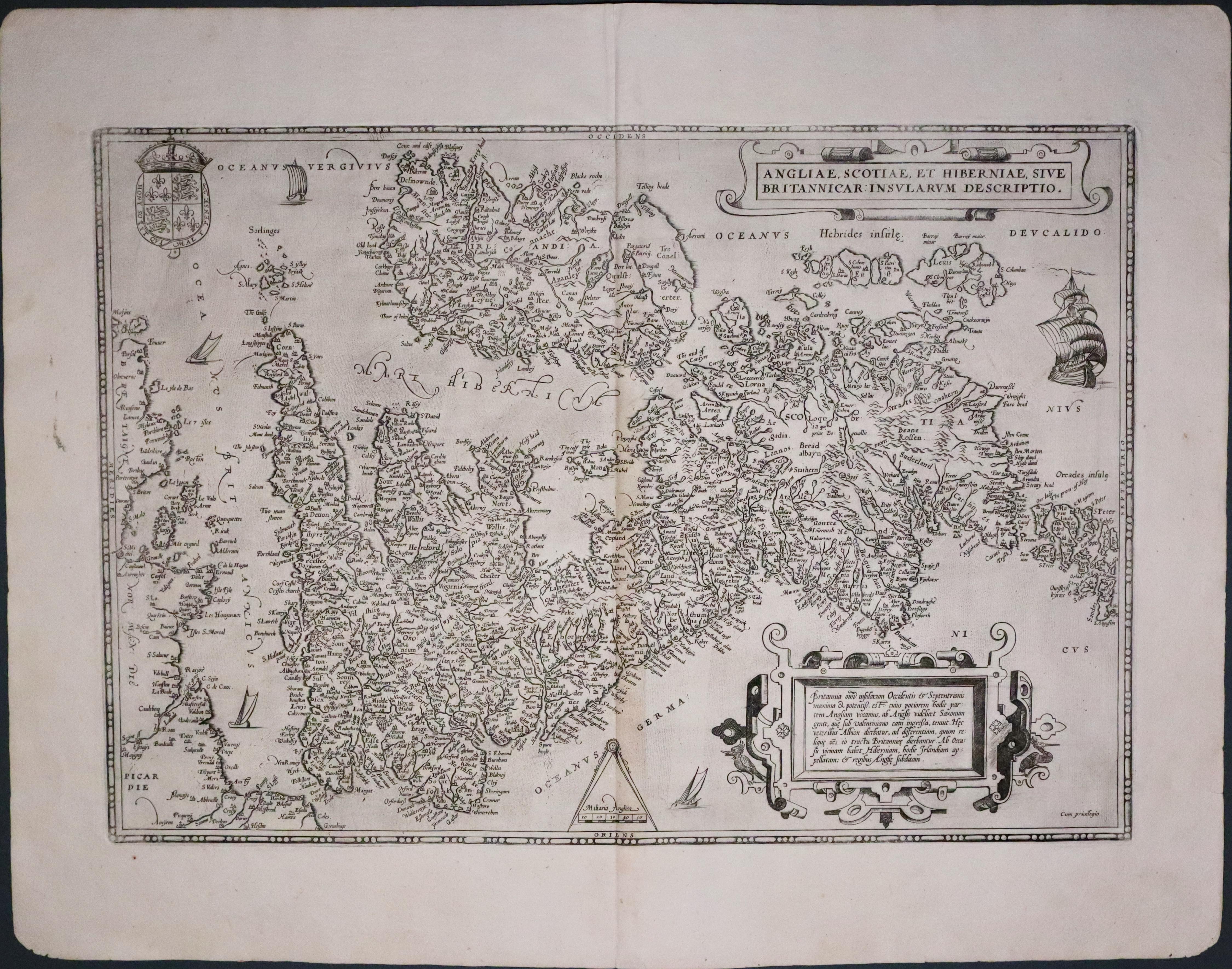
33651 British Isles, Abraham Ortelius, c.1589. Price: 680.00
ANGLIAE, SCOTIAE, ET HIBERNIAE SIVE BRITANNICAR: INSULARUM DESCRIPTIO
A fine early map of the British Isles orientated with west at the top. It is based on Gerard Mercator’s earlier map of the British Isles in 1564.Embellished with two decorative cartouches. Scale with pair of dividers. Royal Arms. Ship. Latin text on verso. 19 1/2 x 13 1/2 inches. Orignal centre fold. Nice clean condition with large blank margins. Uncoloured
From: Theatrum Orbis Terrarum

RICHARD NICHOLSON
of CHESTER
Stoneydale
Pepper Street
Christleton
Chester
CH3 7AG
Telephone
01244 336004
International 44 1244 336004

I have been buying and selling antique maps since the early 1960's during which time I had a gallery in Watergate Street, Chester for 30 years. I am now able to offer through my websites a personal service to map and print collectors.

