Antique Maps of the Aegean
& Albania
Richard Nicholson of Chester

Established in 1961
A World of Antique Maps and Prints

The maps on this page are guaranteed to be genuine early specimens published in or around the year stated
AEGEAN
18th Century Sea Chart
-

Cherse on Serifos, Joseph Roux, 1764

27934 Cherse on Island of Serifos, Joseph Roux, 1764. Price: 43.00
PLAN DU PORT DE CHERSE
A small engraved chart of this bay on the southern coast of the Greek island of Serifos in in the Aegean. 7 1/2 x 5 inches. Good clean condition.
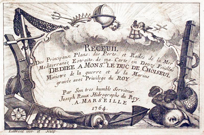
Plate 87 From Receuil Des Principaux Plans; des Ports, et Rades de la Mer Mediterranée, Estraits, de ma. Carte Douze Feüilles.... Marselle 1764
18th Century Sea Chart
-

Kéa or Zea, Joseph Roux, 1764

27948 Kéa or Zea, Joseph Roux, 1764. Price: 43.00
PLAN DU PORT DE ZEA SUR I’ISLE DE CE NOM
A small engraved chart showing the town of Zea on the island of Zea. Zea is a northerly island in the Cyclades and nearest of the group to Attica. Shows the depth soundings and anchorage points. 7 1/2 x 5 inches. Uncoloured. Good condition.
Plate 88 From: Receuil Des Principaux Plans; des Ports, et Rades de la Mer Mediterranée, Estraits, de ma. Carte Douze Feüilles.... Marselle 1764
Kéa or Keos , Lat. Ceos, island (1991 pop. 1,787), c.61 sq mi (160 sq km), SE Greece, in the Aegean Sea; one of the Cyclades. Fruits, barley, and silk are produced. Kéa, the main town, is situated on the site of ancient Iulis. The poets Bacchylides and Simonides were born on the island. Under Ottoman rule it was a pirates' haven, when it was also called Zea, Zia, or Tzia.
18th Century Sea Chart
-

Zira, Joseph Roux, 1764

27949 Zira, Joseph Roux, 1764. Price: 40.00
PLAN DU PORT ZIRA SUR L’ISLE DE CE NOM
A small engraved chart showing the town of Zira and bay. Shows the depth sounding and anchorage points. 7 1/2 x 5 inches. Uncoloured. Good condition.
Plate 89 From: Receuil Des Principaux Plans; des Ports, et Rades de la Mer Mediterranée, Estraits, de ma. Carte Douze Feüilles.... Marselle 1764
18th Century Sea Chart
-

Paros, Joseph Roux, 1764

27950 Paros, Joseph Roux, 1764. Price: 40.00
PORT PAROS SUR L’ISLE DE CE NOM
A small engraved chart showing the bay and town of Paros on the Greek island of Paros. Shows the depth soundings and anchorage points. 7 1/2 x 5 inches. Uncoloured. Good condition.
Plate 90 From Receuil Des Principaux Plans; des Ports, et Rades de la Mer Mediterranée, Estraits, de ma. Carte Douze Feüilles.... Marselle 1764
18th Century Sea Chart
-

Part of the Isle of Paros, Joseph Roux, 1764

27951 Paros, Joseph Roux, 1764. Price: 40.00
ISLE PAROS A small engraved chart showing part of the coast of the island of Paros with Port Treo. Shows the depth soundings and anchorage points. 7 1/2 x 5 inches. Uncoloured. Good condition.
Plate 91 Receuil Des Principaux Plans; des Ports, et Rades de la Mer Mediterranée, Estraits, de ma. Carte Douze Feüilles.... Marselle 1764
18th Century Sea Chart
27953 St. Georges Island, Joseph Roux, 1764. Price: 45.00
PLAN DU PORT DES TROIS BOUCHES SUR I;ISLE SAINT GEORGE D’ESQUIRO
A small engraved chart showing part of the island of St. George in the Cyclades. Shows the soundings and anchorage points 7 1/2 x 5 inches. Uncoloured. Good condition.
Plate 93 From Receuil Des Principaux Plans; des Ports, et Rades de la Mer Mediterranée, Estraits, de ma. Carte Douze Feüilles.... Marselle 1764
18th Century Sea Chart
-

Skiathos, Joseph Roux, 1764

27955 Skiathos, Joseph Roux, 1764. Price: 48.00
PLAN DU PORT DE CHATTE
A small engraved chart showing the coast around the port of the island of Skiathos . Shows the depth soundings and anchorage points. 7 1/2 x 5 inches. Uncoloured. Good condition.
Plate 94 From: Receuil Des Principaux Plans; des Ports, et Rades de la Mer Mediterranée, Estraits, de ma. Carte Douze Feüilles.... Marselle 1764
18th Century Sea Chart
-

Skiathos, Joseph Roux, 1764

27971 Chios, Joseph Roux, 1764. Price: 45.00
I, SCIO
A small engraved chart of the Eastern coast of the Island of Chios in the Aegean. It shows the town and port of Scio.Scale. 7 3/4 x 5 inches. Uncoloured. Good condition. Straight from the atlas and not previously been sold as a single map.
Plate 106 From Receuil Des Principaux Plans; des Ports, et Rades de la Mer Mediterranée, Estraits, de ma. Carte Douze Feüilles.... Marselle 1764
18th Century Sea Chart
-

Port Sigre, Lesbos, Joseph Roux, 1764

27976 Port Sigre, Lesbos, Joseph Roux, 1764. Price: 48.00
PLAN DU PORT SIGRE SUR L’ISLE METELIN
A small engraved chart showing Port Sigre on the island of Lesbos. Shows the depth soundings and anchorage points. Scale. 7 1/2 x 5 inches. Uncoloured. Good condition.
Plate 101 From: Receuil Des Principaux Plans; des Ports, et Rades de la Mer Mediterranée, Estraits, de ma. Carte Douze Feüilles.... Marselle 1764
18th Century Sea Chart
-

Thessalonika, Greece, Joseph Roux, 1764

27981 Thessaloniki, Joseph Roux, 1764. Price: 48.00
GOLFE DE SALONIQUE
A small engraved chart of of Thessalonika on the Thermatic Gulf. Compass pointer with rhumb lines. Depth soundings and anchorage points are also shown. 7 1/2 x 5 inches. Uncoloured. Good condition.
Plate 96 From Receuil Des Principaux Plans; des Ports, et Rades de la Mer Mediterranée, Estraits, de ma. Carte Douze Feüilles.... Marselle 1764
17th Century Miniature
-

Rhodes Alain M. Mallet c.1685

31983 Rhodes, Alain M. Mallet c.1685. Price: 49.00
ISLE DE RHODE
An attractive small map showing part of the Aegean coastline with the island of Rhodes. Title banner. Ships engaged in battle. 4 x 5 3/4 inches. Atrractive hand colouring. Lightly toned. Brown strip on the top edge of the blank margin where the map has been held into a mount. Small single worm hole in the sea area south of the island. Otherwise good condition.
From: Description de l'Univers
Alain Manesson Mallet ( 1603 - 1706 ). Engineer. Served with Portuguese Army before returning to France and serving Louis XIV.
19th Century
-

Turkey and the Aegean, Archibald Fullaton 1862

32008 Turkey and the Aegean, Archibald Fullarton, 1862. Price: 30.00
TURKEY; CENTRAL MEDITERRANEAN REGIONS
Two maps on one sheet surrounded by views of places and people. The upper map shows the Aegean and Greek Islands. The lower map is of Constantinople. Some 11 3/4 x 17 1/2 inches. Small tear in the bottom margin just extending into the illustration Mecca Caravan. Browning around the edges.
From: The Royal Illustrated Atlas published by Archibald Fullarton and Company
16th Century
-

Lesbos, Tomaso Poracchi c.1580

32282 Lesbos, Tomaso Porcacchi, c.1580. Price: 110.00
METELLINO
A small early engraved map of the island of Lesbos within a page of French text. The map is embellished with a decorative title cartouche, compass rose and three sea monsters. 5 1/2 x 4 inches, 140 x 100 mm. Underneath is a decorative initial letter followed by Italian text which continues onto the reverse side. Uncoloured. Two light diagonal creases barely visible otherwise good clean condition.
From: L'Isole del Mondo
16th Century
33341 Milos, Tomaso Porcacchi, c.1580. Price: 98.00
MILO. A small early engraved map of the island of Milos situated in the southern part of the Cyclades islands. The map is embellished with a decorative title cartouche, compass rose and three sea monsters. 5 1/2 x 4 inches, 140 x 100 mm. Underneath is a decorative initial letter A followed by Italian text which continues onto the reverse side. Page numbered 121 / 122 Uncoloured. Good condition.
From: L'Isole del Mondo.
17th Century
-

South Aegean Islands, Jan Jansson c.1650

33721 Southern Aegean Sea, Jan Jansson c.1650. Price: 220.00
ARCHIPELAGI MERIDIONALIS, SEU CYCLADUM INSULARUM ACCURATA DELINEATO. AUTORE LAURENBERGIO
A fascinating 17th century engraved if the southern islands in the Agean Sea. An attribution is given to the creator of the map is given in the title banner that stretches rifht across the to of the map, Professor Johannes Wilhelm Laurenberg who lived from 1590 to 1658. It appears in an atlas published by the Dutch cartographer Jan Jansson. Scattered amongst the islands are illustrations of sea monsters and sailing ships. Putti display the banner showing four scales. 21 1/4 x 18 1/4 inches. Uncoloured. Original centre fold. No top blank margin. Small area of expert restoration in the top left hand corner of the title banner. Small mark in the left hand blank marin, otherwise good clean condition.
ALBANIA
18th Century
-

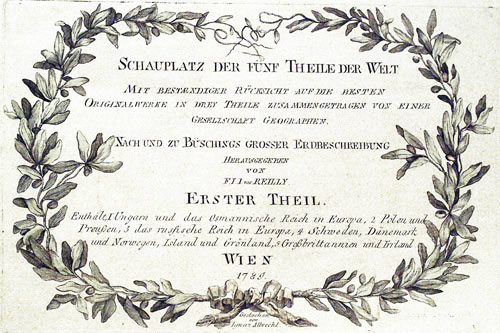
Noerdliche Theil des Koenigreichs Albanien mit dem Distrikte Montenegro. Nro. 21 von Reilly 1789

23983 Northern Albania and Montenegro, Franz Johann von Reilly, 1789. Price: 55.00
Der Noerdliche Theil des Koenigreichs Albanien mit dem Distrikte Montenegro. Nro. 21. An engraved map showing tjhe region of northern Albania and Montenegro. 12 x 81/2 inches. Some original outline and wash hand colouring. Good condition. Straight from the atlas.
From: Schauplatz der funf Theile der Welt published in 1789

RICHARD NICHOLSON
of CHESTER
Stoneydale
Pepper Street
Christleton
Chester
CH3 7AG
Telephone
01244 336004
International 44 1244 336004

I have been buying and selling antique maps since the early 1960's during which time I had a gallery in Watergate Street, Chester for 30 years. I am now able to offer through my websites a personal service to map and print collectors.

