19th Century Maps of the British Isles
Richard Nicholson of Chester

Established in 1961
A World of Antique Maps and Prints

The maps on this page are guaranteed to be genuine early specimens published in or around the year stated
19th Century - Fishing
-

Scad or Horse Mackerel map by O. T. Olsen 1883

14563 Scad or Horse Mackerel, O. T. Olsen, 1883. Price: 80.00
SCAD OR HORSE MACKEREL
A lithograph map of England, Wales and Scotland showing the fishing grounds for this fish. Embellished with an illustration of the fish with details as to the Time of Spawning, number of eggs, when caught, how caught, bait, food, size, weight, quality, when in season and remarks. Hand coloured view of a Yarmouth Drift Boat. 14 x 18 inches. Good condition.
From: The Piscatorial Atlas.
19th Century - Early Hand Colouring
-

England and Wales, Samuel Lewis, c.1840

29796 England and Wales, Samuel Lewis, c.1840. Price: 18.00
MAP OF ENGLAND & WALES DIVIDED INTO COUNTIES SHEWING THE PRINCIPAL ROADS, RAILWAYS, CANALS & THE RIVERS AS FAR AS THEY ARE NAVIGABLE. DRAWN BY R. CREIGHTON ENGRAVED BY THOS. STARLING. LONDON
An interesting map of England and Wales. 15 x 18 1/4 inches. Original outline hand colouring. Tear on the left hand side of the maps and some splits in folds. Some soiling and faint foxing. Framed some years ago in a black and gilt moulding which is still in reasonable condition.
From Lewis’ Topographical Dictionary
This map is only available to customers who can collect from Christleton
19th Century - Early Hand Colouring
-

England and Wales, Henry Teesdale, circa 1835

29803 England and Wales, Henry Teesdale, circa 1835. Price: 45.00
ENGLAND & WALES
A Large detailed map of England and Wales divided into counties. Scale and compass rose. 20 x 24 3/4 inches. Fine original outline and wash hand colouring. Fold creases evident as this map appears in the atlas folded. Otherwise nice clean condition. In a sunk mount and framed some years ago in a plain black moulding. There could be a date under the mount at the base of the map but this is hidden.
This map is only available to customers who can collect from Christleton
19th Century - Early Hand Colouring
-

English Channel, John Thomson, 1814

30290 English Channel, John Thomson, 1814. Price: 45.00
THE BRITISH CHANNEL
An engraved map dated 1814. Shows England and Wales south of Milford Haven and Colchester. European coast from Boulogne to Cape Finistere. 25 x 20 inches. Original outline colouring. A little light creasing across the centre of the map otherwise good condition. Publisher's imprint beneath the map dated 1814.
From: New General Atlas
19th Century - Roads and Railways
-

England and Wales, Archibald Fullarton, c.1834

30316 England and Wales, Archibald Fullarton, c.1834. Price: 45.00
A MAP OF ENGLAND AND WALES TAKEN FROM THE GOVERNMENT MAP MADE BY ORDER OF THE BOARD OF ORDNANCE PUBLISHED BY ARCHBALD FULLARTON & CO. GLASGOW
An interesting engraved map of England and Wales showing by use of coloured red and blue lines the routes of mail coach routes and railways. 16 1/4 x 19 1/4 inches. Some fold creases. Some scattered foxing over the map surface. Put into a darlkgreen 2 inch mount and framed in a black and gilt moulding many years ago. The frame is still in reasonably good condition.
Only available to customers who can collect from Christleton
Late 19th Century - Weather
-

England and Wales - Average Temperature, John Bartholomew, c.1895

30361 England and Wales - Average Temperature, John Bartholomew, c.1895. Price: 11.00
AVERAGE TEMPERATURE
A colour printed sheet showing six maps of England and Wales showing the average temperatures in January, March, May, July, September and November. 16 1/2 x 12 3/4 inches. Good clean condition.
From: The Royal Atlas
Late 19th Century - Railways
-

Railways Northern England and Scotland, John Bartholomew, c.1898

30907 Railways Northern England and Scotland, John Bartholomew, c.1898. Price: 18.00
RAILWAYS, NORTHERN DIVISION
A colour printed map showing Norrh England and Scotland as far north as Perth. Inset map of the Preston, Liverpool, Manchester region. Scale of 19 miles to the inch. Centre fold. 16 1/2 x 12 1/2 inches. Good clean condition.
From: The Royal Atlas
Late 19th Century - Railways
-

Railways Southern England and Wales, John Bartholomew, c.1898

30908 Railways Southern England and Wales, John Bartholomew, c.1898. Price: 18.00
RAILWAYS, SOUTHERN DIVISION
A colour printed map showing Southern England and the whole of Wales. Inset map of the tip of Cornwall Scale of 19 miles to the inch. Centre fold. 16 1/2 x 12 1/2 inches. Good clean condition.
From: The Royal Atlas
19th Century - Tables
-

England and Wales Tables, John and Charles Walker, 1851

31400 England and Wales Tables, John and Charles Walker, 1851. Price: 12.00
ENGLAND & WALES
Five small folio sheets from the atlas showing 42 panels county panels showing details about Market Towns, Fair Days, Population and Distances. Plus a table showing distances between the principal towns. Uncoloured. Good condition.
From: The British Atlas
Late 19th Century
-

Part of East England, John Bartholomew, c.1898

31489 Part of East England, John Bartholomew, c.1898. Price: 18.00
SECTION VI, YORK
A colour printed map showing part of West Yorkshire from Clitheroe and Sedbergh in the west to York and Helmsley in the east with Leeds to the south. Scale of 4 miles to the inch. Shows the railways. 16 1/2 x 12 1/2 inches. Good clean condition.
From The Royal Atlas
Late 19th Century - Temperatures
-

Average Temperatures, John Bartholomew, c.1898

31495 Average Temperatures, John Bartholomew, c.1898. Price: 11.00
LAND SURFACE FEATURES
A colour printed sheet showing by the use of a key and four colours the areas of Grass and Cultivated Land, Woodland, Morrland, Hill Pasture and Fenland. Centre fold as issued. 16 1/2 x 12 3/4 inches. Good clean condition.
From: The Royal Atlas
Late 19th Century
-

Land Surface Features, John Bartholomew, c.1898

31496 Land Surface Features, John Bartholomew, c.1898. Price: 11.00
LAND SURFACE FEATURES
A colour printed sheet showing by the use of a key and four colours the areas of Grass and Cultivated Land, Woodland, Morrland, Hill Pasture and Fenland. Centre fold as issued. 16 1/2 x 12 3/4 inches. Good clean condition.
From The Royal Atlas
Late 19th Century
-

Ecclesiastical Divisions, John Bartholomew, c.1898

31507 Ecclesiastical Divisions, John Bartholomew, c.1898. Price: 18.00
ECCLESIASTICAL DIVISIONS
A colour printed map showing of England and Wales with a further small inset maps of England and Wales and the Channel Islands. Centre fold as issued. 16 1/2 x 12 1/2 inches. Good clean condition.
From: The Royal Atlas
Late 19th Century
-

Geological, John Bartholomew, c.1898

31508 Counties and Boroughs, John Bartholomew, c.1898. Price: 18.00
COUNTIES & BOROUGHS
A colour printed map showing of England and Wales with a further inset map of London Council and Parliamentary Divisions. Centre fold as issued. 16 1/2 x 12 1/2 inches. Good clean condition.
From: The Royal Atlas
Late 19th Century - Railways
-

Railways Northern England, John Bartholomew, c.1898

31510 Railways Northern England, John Bartholomew, c.1898. Price: 17.00
RAILWAYS, NORTHERN DIVISION
A colour printed map showing North England and Scotland as far north as Perth. Inset map of the Preston, Liverpool, Manchester region. Scale of 19 miles to the inch. Centre fold. 16 1/2 x 12 1/2 inches. Small ink stain in the bottom blank margin other good clean condition.
From: The Royal Atlas
Late 19th Century - Political
-

Parliamentary Representations, John Bartholomew, c.1898

31512 Parliamentary Representations, John Bartholomew, c.1898. Price: 18.00
PARLIAMENTARY REPRESENTATION
A colour printed map divided into two section each showing a map of England and Wales. The left hand side map shows the Counties and their Subdivisions. The right hand side map shows the Parliamentary Boroughs. Centre fold. 16 1/2 x 12 1/2 inches. Good clean condition.
From: The Royal Atlas
Late 19th Century - Population
-

Density of Population, John Bartholomew, c.1898

31513 Density of Population, John Bartholomew, c.1898. Price: 18.00
DENSITY OF POPULATION
A colour printed map showing of England and Wales showing the population density helped by the use of a colour code table. Centre fold as issued. Scale of 27 miles to the inch. 12 1/2 x 16 1/2 inches. Good clean condition.
From: The Royal Atlas
19th Century
-

England and Wales Joshua Archer c.1845

31566 England and Wales, Joshua Archer, c.1845. Price: 12.00
ENGLAND & WALES
An engraved map of England and Wales divided into counties. List of counties with key. 7 1/2 x 9 1/2 inches. Original centre fold. Uncoloured. Good condition with no tears or repairs.
From: England & Wales Delineated
19th Century - Railways
-

England and Wales Joshua Archer c.1845

31568 England and Wales, Joshua Archer, c.1845. Price: 19.00
ENGLAND & WALES WITH ITS RAILROADS & CANALS
A map drawn and engraved by J. Archer, Pentonville, London of England and Wales divided into counties. List of counties with key. 7 1/2 x 9 1/2 inches. Original centre fold. Uncoloured. Few small brown marks in blank margin. Good condition with no tears or repairs.
From England & Wales Delineated
An interesting map showing the extent of the railways in early Victorian England and Wales
Late 19th Century
-

British Isles - Industries, George Philip

32217 British Isles - Industries, George Philip & Son, c.1906. Price: 7.00
EUROPE: INDUSTRIES & COMMUNICATIONS
A detailed colour printed map of Europe indicating. Also shows distances. 18 3/4 x 13 3/4 inches. Original centre fold. Good condition.
From: The Harmsworth Universal Atlas published by The Amalgamated Press
Late 19th Century - Railways
-

North of England Railways, George Philip c.1906

32219 North of England Railways, George Philip & Son,c.1906. Price: 7.00
THE NORTH OF ENGLAND & SOUTH SCOTLAND: RAILWAY SYSTEMS.
A detailed colour printed map of the north of England and south Scotland indicating the railways in a colour system, a reference for which appears within a panel. Inset map of London. Original centre fold. 18 3/4 x 13 3/4 inches. Good condition.
From: The Harmsworth Universal Atlas published by The Amalgamated Press
Late 19th Century - Railways
-

South of England Railways, George Philip c.1906

32220 South of England Railways, George Philip & Son, c.1906. Price: 7.00
THE SOUTH OF ENGLAND : RAILWAY SYSTEMS
A detailed colour printed map of the south of England indicating the railways in a colour system, a reference for which appears within a panel.. Original centre fold. 18 3/4 x 13 3/4 inches. Good condition.
From: The Harmsworth Universal Atlas published by The Amalgamated Press
Late 19th Century - Folding Railway Map
-

British Isles - Industries, George Philip
-

British Isles - Industries, George Philip
-

British Isles - Industries, George Philip
-

British Isles - Industries, George Philip


32350 England and Wales Railways, John Airey, 1884. Price: 96.00
AIREY’S RAILWAY MAP OF ENGLAND AND WALES COMPILED FROM THE ORDNANCE SURVEY AND OFFICIAL SOURCES BY JOHN AIREY RAILWAY CLEARING HOUSE LONDON. PUBLISHED BY Mc. CORQUODALE & CO. LTD. 55 CARDINGTON STREET, EUSTON SQUARE, LONDON 1884
This large folding lithograph map was drawn and engraved by J & W. Enslie. 28 1/2 x 30 1/2 inches plus margins, dissected into 25 parts and mounted on linen. Loose but within morocco titled boards. The top left section of the map is pasted onto the inside back of the boards. Some stains down the right of the map, perhaps caused by handling. A few other minor ink stains. Quite a number of the folds have some sellotape strengthening on verso.
JOHN AIREY: Flourished 1867 - 1900. Worked for the Distances Section of the Mileage Department of the Railway Clearing House and used his records to produce numerous railway maps of English regions.
19th Century - Railways Folding Map
-

Large folding map of north east sheet England and Wales - Railways Aaron Arrowsmith 1840
-

Large folding map of north west sheet England and Wales - Railways Aaron Arrowsmith 1840
-

Large folding map of south east sheet England and Wales - Railways Aaron Arrowsmith 1840
-

Large folding map of south east west England and Wales - Railways Aaron Arrowsmith 1840


32366 England and Wales - Railways, Aaron Arrowsmith, 1840. Price: 190.00
MAP OF THE RAILWAYS, Showing the various stations with the hills, rivers, canals, and principal roads, of England and Wales, also Exhibiting most of the places whose situation has been ascertained by the Stations and Intersections of the Trigonometrical Survey, Compiled by A.Arrowsmith
An amazing and fascinating map of England and Wales drawn on a scale of 6 miles to the inch. Published in London March 23rd by G. F. Cruchley at 81 Fleet Street. On four sheets. Each sheet has been divided into 18th sections, mounted on linen with green cloth edging and folding. Each section titled on the green cloth front when folded. The south east sheet bears a reference table to the stations on the railroads. Key to the colours used to denote lines completes, in progress and projected. Each section measures some 28 1/2 x 38 inches with original hand colouring. All in good undamaged condition.
Late 19th Century - Geological
-

Northern Sheet Geological map of England and Wales by George Washington Bacon c.1883
-

Southern Sheet Geological map of England and Wales by George Washington Bacon c.1883


32538 England and Wales - Geological, c.1883. Price: 44.00
GEOLOGICAL MAP OF ENGLAND AND WALES
An interesting detailed late 19th century coloured lithograph geological map of England and Wales on two sheets. Key to the geological groups. It also shows the railways. Each sheet measures 19 1/4 x 12 inches. Original centre fold to each. Good clean condition.
20th Century
-

South East England Ordnance Survey 1934
-

Map cover Ordnance Survey South East England 1934


32587 South East England, Ordnance Survey, 1934. Price: 10.00
ENGLAND, SOUTH-EAST AND LONDON
The 4th edition of this Ordnance Survey of Great Britain “Quarter Inch” Map. Sheet 12. Centred on London and showing the south est from Colchester Luton and Aylesbury in the north to the south coast with Portsmouth Brighton and the whole of Kent. Folding sheet showing 24 town plans. Some 34 x 22 inches. Mounted on linen and folding. Pictorial titled cover. The map is in fine clean condition. The cover is toned with slight damage to the top and bottom edges.
Late 19th Century
-

Northern England John Bartholomew, c.1898

32749 Northern England John Bartholomew, c.1898. Price: 12.00
GEOGRAPHICAL FEATURES, SECTION I
A colour printed map showing part of Scotland from Berwick-upon-Tweed in the north to Liverpool and Manchester in the south. Small inset map of the Isle of Man. Scale of 10 miles to the inch. Shows the railways. 16 3 /4 x 12 1/2 inches. Good clean condition.
From: The Royal Atlas
19th Century - Geological
-

Geological map of England and Wales by John Bartholomew, c.1898

32758 England and Wales - Geological, John Bartholomew c.1898. Price: 24.00
GEOLOGICAL FEATURES
A colour printed map showing of England and Wales showing the geological features helped by the use of a colour code table. Centre fold as issued. Scale of 27 miles to the inch. 12 1/2 x 16 1/2 inches. Good clean condition.
From: The Royal Atlas
Late 19th Century
-

England and Wales by John Bartholomew, c.1898

32760 England and Wales, John Bartholomew c.1898. Price: 11.00
LAND SURFACE FEATURES
A colour printed sheet showing by the use of a key and four colours the areas of Grass and Cultivated Land, Woodland, Moorland, Hill Pasture and Fenland. Centre fold as issued. 16 1/2 x 12 3/4 inches. Good clean condition.
From: The Royal Atlas
Late 19th Century
-

Map of Averge Rainfall in England and Wales by John Bartholomew, c.1898

32761 Rainfall - England and Wales, John Bartholomew c.1898. Price: 18.50
AVERAGE RAINFALL
A colour printed sheet showing six maps of England and Wales showing the average rainfall in January, March, May, July, September and November. 16 1/2 x 12 3/4 inches. Good clean condition.
From: The Royal Atlas
Late 19th Century
-

Northern England by John Bartholomew, c.1898

32780 Northern England, John Bartholomew c.1898. Price: 18.00
GEOGRAPHICAL FEATURES, SECTION I.
A colour printed map showing part of Scotland from Berwick-upon-Tweed in the north to Liverpool and Manchester in the south. Small inset map of the Isle of Man. Scale of 10 miles to the inch. Shows the railways. 16 3 /4 x 12 1/2 inches. One inch split at one end of the centre fold otherwise good clean condition.
From: The Royal Atlas
19th Century - Large
-

England & Wales, James Pigot. c.1830

32875 England and Wales, James Pigot, 1825. Price: 95.00
PIGOT’S MAP OF ENGLAND & WALES WITH PART OF SCOTLAND
A large engraved map with decorative title in the top right hand corner. Explanation beneath. Original outline hand colouring. Dissected into 16 sections and mounted on linen. Beneath the map is the imprint of J. Pigot & Co. dated 1830. 20 1/2 x 26 1/2 inches. Two original folds. Small split at left hand horizontal fold. Split and tear at other end which extends an inch or so into the sea area. Split in wide bottom margin at the base of the vertical fold. Not unusual for this map.
19th Century - List of Towns
-

List of Places, John Cary 1802

32886 List of Places, John Cary, 1824. Price: 14.00
LIST OF PLACES GIVEN IN CARY’S MAP OF ENGLAND AND WALES, WITH PART OF SCOTLAND
The 96 quarto pages listing towns from the 1824 edition of this large scale map. Bound but no covers. The last page is quite interesting as it shows adverts for a number of Cary’s atlases and globes with prices.

19th Century
-

Map of England and Wales by Thomas Letts

32954 England Wales, Thomas Letts, 1884. Price: 10.00
KEY MAP OF ENGLAND
A detailed chromolithograph map of England and Wales showing the counties. This map comes from Lett’s Popular Atlas. 12 3/4 x 15 1/2 inches. Original centre fold. Imprint of Letts & Son beneath. Splits at each end of the centre fold otherwsie fine clean condition. Straight from the atlas so never previously been sold as a single map.
From: Lett’s Popular County Atlas
19th Century - Early Hand Colouring
-

Map of England and Wales by John Tallis c.1851

33036 England Wales, John Tallis, c.1851. Price: 58.00
ENGLAND & WALES
A detailed map within an oak leaf patterned border. Embellished with the royal arms and seven vignette views including Doncaster Races, London, Portsmouth Harbour and Newcastle-upon-Tyne. 10 x 13 inches. Original outline hand colouring. Single tear in the top blank margin just reaching the printed border, repaired. No left hand blank margin wih some trimming to the printed leaf pattern. Otherwise good condition. Stout paper.
From: John Tallis's Illustrated Atlas
19th Century - Early Hand Colouring
-

Map of England and Wales by Joshua Archer c.1845

33048 England and Wales, Joshua Archer, c.1845. Price: 9.00
ENGLAND & WALES
A map drawn and engraved by J. Archer, Pentonville, London of England and Wales divided into counties. List of counties with key. 7 1/2 x 9 1/2 inches. Original centre fold. Original outline hand colouring. Short splits at the each end of the centre fold. Small tear in the left hand blank margin.
From England & Wales Delineated
19th Century - Early Hand Colouring
-

Map of England and Wales by John Roper 1810

33217 England Wales, George Cole and John Roper, 1810. Price: 14.00
ENGLAND AND WALES FORMING AN INDEX MAP TO THE BRITISH ATLAS
An engraved map showing the counties and main coach roads. List of counties. 8 x 9 3/4 inches. Original wash hand colouring. Publishers imprint beneath dated 1809. A little dust soiling in the blank margins otherwise good clean condition.
From The British Atlas
19th Century - History
-

Historical Table England 1066 to 1484 by C V Lavoisne

33393 Historical Table 1066 - 1485, C. V. Lavoisne, 1830. Price: 14.00
GENEALOGICAL, HISTORICAL, AND CHRONOLOGICAL MAP OF ENGLAND FROM THE NORMAN INVASION, UNDER WILLIAM THE CONQUEROR, 1066 TO THE ACCESSION OF HENRY VII. 1485. A fascinating table which would make a most interesting wall decoration. 20 1/2 x 16 1/2. Original wash hand colouring. Split at the bottom of the centre fold otherwise good condition. From Lavoisne’s Complete Genealogical, Historical, Chronological, and Geographical Atlas
Historical - People
33394 People & Position 1485 - 1829, C. V. Lavoisne, 1830. Price: 14.00
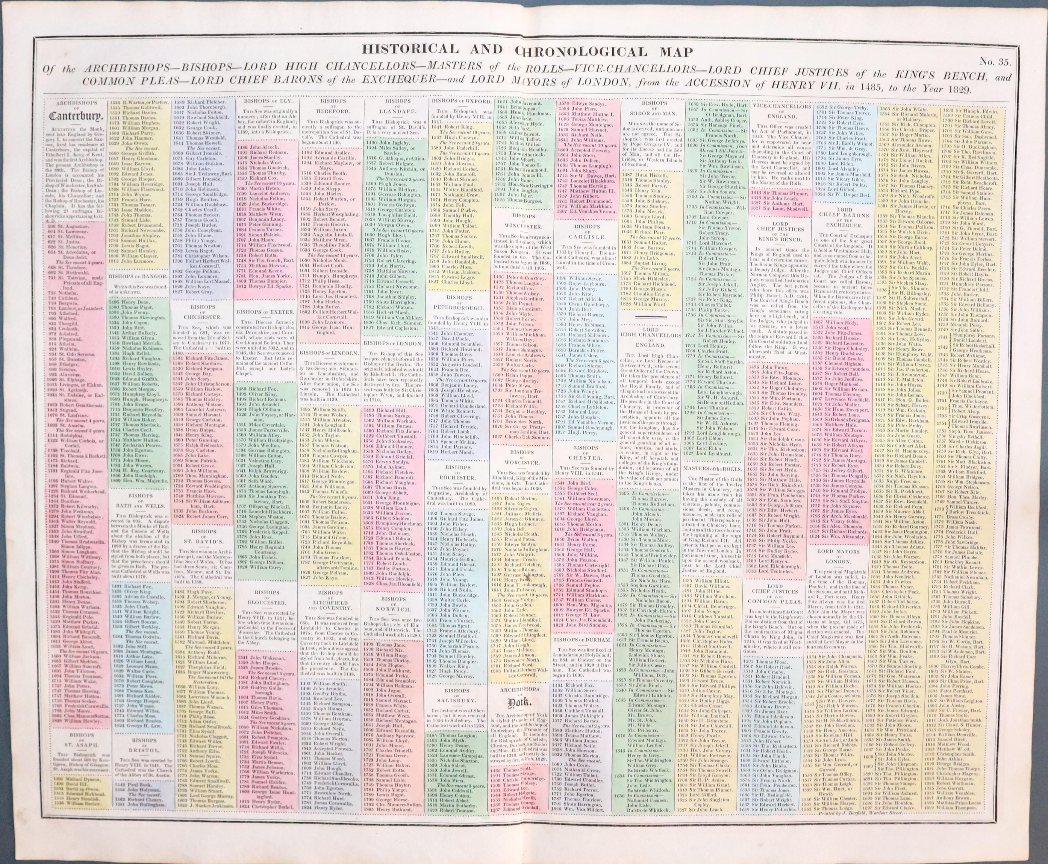
HISTORICAL AND CHRONOOGICAL MAP OF THE ARCHBISHOPS - BISHOPS - LORD HIGH CHANCELLORS - MASTERS OF THE ROLLS .....
A fascinating table listing persons with important positions from 1485 to 1829. 20 1/2 x 16 1/2. Original wash hand colouring. Good condition.
From :Lavoisne’s Complete Genealogical, Historical, Chronological, and Geographical Atlas
19th Century - Detailed
-

England & Wales

33541 England and Wales, Sydney Hall, c.1842. Price: 12.50
ENGLAND AND WALES
An engraved map of England and Wales on two sheets. The northern sheet shows the title and scale. Northern sheet is numbered in top right hand margin Plate CCXIX-1 and th southern sheet CCXIX-2. Imprint of S. Hall, Bury Street, Bloomsbury shown on the southern sheet. Each map measures 14 1/2 x 10 1/4 inches. Each sheet has an original centre fold. Small nick at the bottom of the centre fold of the northern sheet otherwise good clean condition.
Folding - Early Hand Colouring
-

Foldong map of England & Wales by Hodgson 1824

33581 England & Wales, Hodgson, 1824. Price: 72.00
HODGSON’S GEOGRAPHICAL COMPANION THROUGH ENGLAND MAPS AND PART OF SCOTLAND DRAWN FROM THE LATE SURVEYS OF THE DIFFERENT COUNTIES
A folding map dissected into 20 sections and mounted onto linen. Published by Hodgson & Co, 10 Newgate Street London. Panel listing Market and Borough Towns. Map dated 1824 beneath. Original outline and wash hand colouring. 20 3/4 x 28 inches. Very slight damage to one edge of the bottom right hand section. Some light soiling. Soiling on verso.
Victorian Game
-

Spooners Pictorial Map of England and Wales 1844
-

Cover to Spooners Pictorial Map of England and Wales 1844


33606 England and Wales, William Spooner, 1844. Price: 270.00
SPOONER’S PICTORIAL MAP OF ENGLAND & WALES ARRANGED AS AN AMUSING AND INSTRUCTIVE GAME OF YOUTH. ILLUSTRATED WITH UPWARDS OF ONE HUNDRED & TWENTY VIEWS. LONDON: PUBLISHED BY WILLIAM SPOONER, 377 STRAND, NOVR. 5TH 1844
A delightful mid 19th century game where the players start at the oval view of Berwick-on-Tweed and proceed through England and Wales to the 104th oval view which is of London. A lithograph map with original hand colouring dissected into twelve sections and mounted on linen and folding into its original green boards with printed pictorial title label.18 3/4 x 23 1/2 inches. A little light soiling in a few places but generally a nice specimen of this most collectable map.
Note: Ashley Bayton-Williams includes this map in his most informative book “The Curious Map Book

RICHARD NICHOLSON
of CHESTER
Stoneydale
Pepper Street
Christleton
Chester
CH3 7AG
Telephone
01244 336004
International 44 1244 336004

I have been buying and selling antique maps since the early 1960's during which time I had a gallery in Watergate Street, Chester for 30 years. I am now able to offer through my websites a personal service to map and print collectors.

