Antique Maps of Europe
Richard Nicholson of Chester

A World of Antique Maps and Prints
Established in 1961

The maps on this page are guaranteed to be genuine early specimens published in or around the year stated
19th Century - French Revolution
-

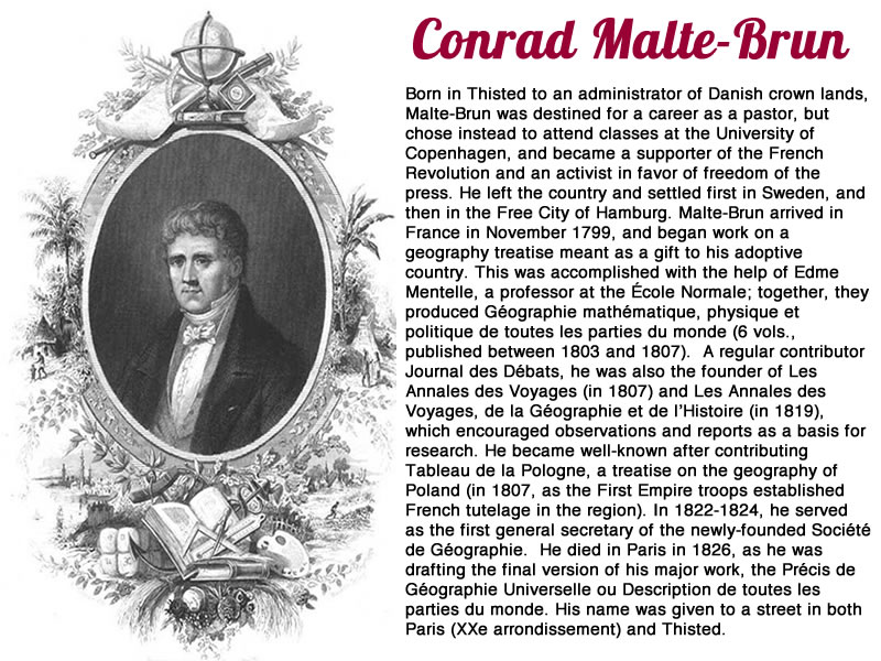
Europe 1500 and 1789 Conrad Malte-Brun 1829
19874 Europe 1500 & 1789, Conrad Malte Brun, 1829. Price: 39.00
EUROPE SOUS CHARLES QUINT / EUROPE EN 1789
Two maps of Europe on one sheet. The upper map shows the continent in the time of the Holy Roman Emperor Charles V, 1500 - 1521 with a figured title cartouche. The map beneath shows the continent in 1789, the year the French Revolution started with the storming of the Bastille on 14th July. The cartouche shows a thunderstorm with lightning. Together they measure 8 1/2 x 11 3/4 inches. Original outline hand colouring. Good clean condition.
From Atlas Complet du Precis de la Geographie universelle...
19th Century - Early Hand Colouring
-

Europe, G H Colton 1864

19951 Europe, George Hutchins Colton, 1864. Price: 30.00
EUROPE
An attractive map of the whole continent bearing the name of the publishers J. H. Colton & Co. No 172 William Street, New York. Hand coloured. 14 1/2 x 11 3/4 inches. Part of a description of The British Empire in English on verso. Good clean undamaged condition.
The Coltons were an important and successful family of American publishers in the 19th century.
19th Century - Early Hand Colouring
-

Part of Ancient Europe, Robert Wilkinson, 1815

24909 Middle Ages, Conrad Malte-Brun, 1812. Price: 32.00
GEOGRAOHIE DU MOYEN AGE PRINERALEMENT IXe ET Xe SIECLES
An engraved map of Europe in the Middle Ages. For European history the Middle Ages was from the end of the Roman Empire in 476 AD to 1500 AD, This map appears to consider the period of 900 to 1000. Extends aouth to incude Arabia and India. Small inset map showing part of Iceland. Decorative title cartouche. Original early outline hand colouring. 11 3/4 x 8 1/2 inches. Manuscript numbering in right hand blank margin. Good condition.
From: Atlas Complete du Précis de la Géographie Universelle
19th Century - Early Hand Colouring
-

Ancient Europe, Conrad Malte-Brun 1812

24896 Ancient Europe, Conrad Malte-Brun, 1812. Price: 40.00
EUROPE ANCIENNE
An engraved map of the continent in ancient times. Embellished with an uncoloured pictorial title cartouche with figures. 11 1/2 x 8 1/2 inches. Original outline hand colouring. Good condition.
From: Atlas Complete du Précis de la Géographie Universelle
19th Century - Early Hand Colouring
-

Ancient Europe, Conrad Malte-B

24908 Ancient Europe, Conrad Malte-Brun, 1812. Price: 34.00
L’EUROPE APRES L’INVASION DE BARBARES....
A historical engraved map of Europe at the time of Barbarians. Pictorial title cartouche. 9 1/2 x 8 1/2 inches. Early outline hand colouring. Manuscript number 18 in wide right hand blank margin.
From: Atlas Complete du Précis de la Géographie Universelle
19th Century - Early Hand Colouring
-

Part of Ancient Europe, Robert Wilkinson, 1815

25940 Part of Ancient Europe, Robert Wilkinson, 1815. Price: 32.00
VINDELICIA RHAETIA ET NORICUM ANTIQUA
An engraved map of the region in ancient times. Publisher’s imprint dated 1801. 11 x 8 3/4 inches. Original outline and wash hand colouring. Good condition.
From: Atlas Classica
Early 19th Century
-

Europe, Richard Brookes 1820

24986 Europe, Richard Brookes, 1820. Price: 20.00
EUROPE FROM THE BEST AUTHORITIES
And engraved map of the continents with an oval title panel. Traces of original fold creases on verso. Good clean condition.
19th Century - Early Hand Colouring

-

Hannibal, Robert Wilkinson, 1815

25953 Hannibal, Robert Wilkinson, 1815. Price: 40.00
EXPEDITIO HANNIBALIS POENORUM DUCIS
An engraved map of the region in ancient times. Dated 1803. 11 x 8 3/4 inches. Original outline and wash hand colouring. Good condition.
From: Atlas Classica
19th Century Sea Chart - Early Hand Colouring
-

North and Baltic Seas, John Thomson, 1827

23138 North and Baltic Seas, John Thomson, 1827. Price: 120.00
CHART OF THE NORTH AND BALTIC SEAS
Interesting chart with three inset charts of the Harbour of Helegoland, Port of Revel and Harbour of St. Petersburg. 23 x 19 inches, 600 x 490 mm. Original outline hand colouring. Some light brown offsetting, otherwise good condition.
From: Thomson's New General Atlas
16th Century - Early Hand Colouring
-

Illyria, Abraham Ortelius, c.1600

23380 Illyria, Abraham Ortelius, c.1600. Price: 350.00
ILLYRICUM
A fine early map of this region. A province first established by the Romans in 9 a.d. The title and attribution to the geographer Johannes Sambucus (1531-1584) appear within a decorative cartouche dated 1572. 19 x 14 1/2 inches. Latin text on verso. Early hand colouring. Fine condition.
From: Theatrum
19th Century - Early Hand Colouring
-
Ancient Europe Conrad Malte-Brun
24896 Ancient Europe, Conrad Malte-Brun, 1812. Price: 40.00
EUROPE ANCIENNE
An engraved map of the continent in ancient times. Embellished with an uncoloured pictorial title cartouche with figures. 11 1/2 x 8 1/2 inches. Original outline hand colouring. Good condition.
From: Atlas Complete du Précis de la Géographie Universelle
16th Century
-

Europe, Giovanni Botero/Girolamo Ruscelli, 1598

29272 Europe, Giovanni Botero/Girolamo Ruscelli, 1598. Price: 225.00
EUROPA
An early engraved map of the continent by Girolama Ruscelli which follows the work of Giovanni d’Anania who published a similar map in Venice in 1582. 9 3/4 x 7 inches. Uncoloured. Latin text on verso. Good clean crisp condition.
From: Ruscelli's Geographiae
18th Century
-

Europe, Emanuel Bowen, c.1750

30645 Europe, Emanuel Bowen, c.1750. Price: 68.00
A NEW AND ACCURATE MAP OF EUROPE DRAWN FROM THE BEST AUTHORITIES.... BY EMANUEL BOWEN, GEOGRAPHER TO THE KING
An engraved map of the whole continent. Pictorial title cartouche with figure.17 1/2 x 4 1/2 inches. Uncoloured. An uneven and narrow bottom border. Two small marginal tears. Some creasing in the wide left hand blank border. Otherwise this would have been a nice specimen of this map as it has no foxing or other tears and repairs and the margins on the three other sides are quite adequate.
16th Century
-

Central and Eastern Euroope, Girolomo Ruscellis, 1599

32280 Central and Eastern Europe, Girolomo Ruscelli, 1599. Price: 85.00
TABULA ASIAE II
An engraved Ptolemaic map based upon a map by Giacomo Gastaldi. Printed by the Sessa family. It shows an area between and Black Sea and the Caspian Sea with part of Ukraine and Armenia. Some 8 x 7 inches. Uncoloured. Original centre fold. Traces of small binding holes in the bottom blank margin Matching single worm holes in the left and right blank side margins. Otherwise very nice clean crisp condition. Straight from the atlas so not not offered previously for sale as a single map.
From the sixth edition of Ruscelli's translation of Ptolemy's Geografia edited and extended by Giuseppe Rosaccio published by the Heirs of Melchior Sessa in 1599.
Late 19th Century
-

Austro-Hungarian Monarchy, W. & A. K. Johnston c.1890

33154 Austro-Hungarian Monarchy, W. & A. K. Johnston, c.1890. Price: 10.00
AUSTRO-HUNGARIAN MONARCHY
A colour printed map of theregion. The name of the publishers W. & A. K. Johnston, Edinburgh & London beneath. 12 x 9 1/8 inches. Original fold creases. Very small area of soiling in the bottom right hand corner otherwise good.
Early 17th Century
-

Europe, Abraham Ortelius, c.1620
-

Text on vrso Europe, Abraham Ortelius, c.1620


33288 Europe, Abraham Orelius, c.1620. Price: 300.00
EUROPAE
An early engraved map of the continent embellished with a title cartouche and single sailing ship. 18 x 13 1/2 inches. Three small circular stains but otherwise the map is in good clean condition. There may have been a spllt in the centre fold but the binding strip has now been pasted down on verso onto the map. Uncoloured. Latin text on verso.
From: Theatrum
Part of Europe by a German Mapmaker
-

England, France & Germany by Dr. Henry Kiepert c.1902

33451 England, France & Germany, Dr. Henry Kiepert, c.1902. Price: 20.00
GALLIA BRITANNIA, GERMANIA
A lithograph map showing England, France and Germany in ancient times. Inset map. 17 x 13 inches inches. Original centre fold. Good condition.
From: Atlas Antiquus published in Berlin
17th Century Text
-

Europe Text, Pieter van den Keere 1668

33707 Europe Text, Pieter van den Keere, 1668. Price: 14.00
THE DESCRIPTION OF EUROPE
Pages 33 to 44. The complete text to accompany the map of Europe from A Prospect of the Most Famous Parts of the World published by Roger Rea in 1668. Page size 6 1/2 x 4 inches. Good condition.

RICHARD NICHOLSON
of CHESTER
Stoneydale
Pepper Street
Christleton
Chester
CH3 7AG
Telephone
01244 336004
International 44 1244 336004

I have been buying and selling antique maps since the early 1960's during which time I had a gallery in Watergate Street, Chester for 30 years. I am now able to offer through my websites a personal service to map and print collectors.

