RICHARD NICHOLSON of CHESTER
A WORLD OF ANTIQUE MAPS AND PRINTS

The Cartographer
JOHN SPEED
John Speed is an English cartographer you are likely to have heard of
as his maps have been reproduced more than any other early maps
"The Theatre of the Empire of Great Britaine"
Maps of England, Wales Scotland and Ireland as well as maps of the English and Welsh Counties, the Islands and the Irish Provinces

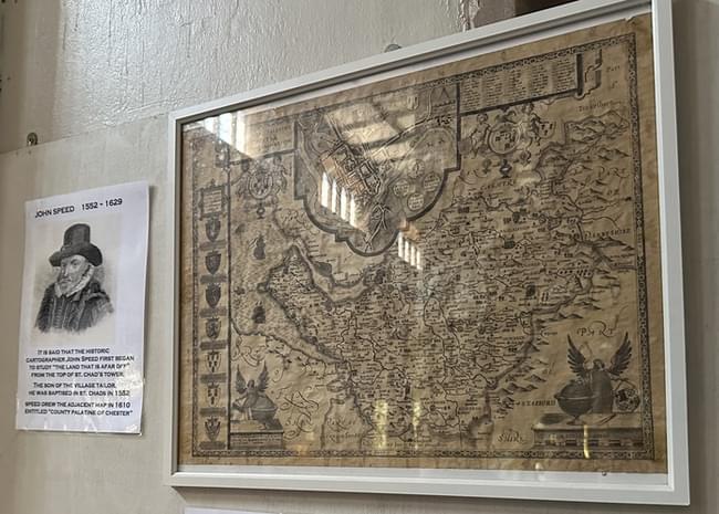
If you go through the little village of Farndon in Cheshire today you are unlikely to see anything to draw your attention to the fact that John Speed was born there. Perhaps, given time, much will be made of the event but today, as in 1552, the happening is, and was, taken as an every day event and John was called John after his father and as soon as he was old enough sewed up the similarity by following in his father's fashion, the trade of a tailor.
He showed an interest in cartography at an early age and to pursue his interest he moved to London to work as an engraver and mapmaker. At the age of 18 John Speed was admitted to the freedom of the Merchant Tailor's Company in London. He rented somewhere to live and a garden in Moorfields for twenty shillings a year.
At the age of 20 he married and continued his manual employment in the business of garments. Doubtless he was well employed for these were the days of Queen Elizabeth when colour and style in dress left a vivid and interesting image in our island history.
Undoubtedly a fine family man, John Speed could apply only his spare time to history and mapmaking, for tailoring brought in the money to bring up his brood of twelve sons and six daughters. His son Samuel in later years became implicated in a plot against Cromwell and was forced to flee the country for the West Indies where he joined some buccaneers and later became a sea chaplain.
Perhaps we would not have seen the fine maps of John Speed if a courtier of good literary taste and discernment had not used his influence to further the careers of talented men. The courtier was Sir Fulke Greville, the first Lord Brooke, a lifelong friend of Sir Philip Sydney.
Thus is was in 1598, with Speed at the age of 48, that Queen Elizabeth gave him a Waiters room in the custom house and at last Speed was able to pass onto us what had been in his mind.
He first devoted himself to writing a history and preparing a series of county maps of England and Wales. Between 1605 and 1610 he collected material including manuscript maps, coats of arms, portraits, drawings of antiquaries and rubbings of coins which he passed onto Jodocus Hondius in Amsterdam who engraved most of the maps for the Theatre of the Empire of Great Britain. During this time Speed must have travelled extensively in the British Isles acquiring information for his unique series of town plans that appear on his maps, which are the earliest recorded plans for many of the towns featured, Proofs of his maps were issued between 1608 and 1610 and in 1611-12 all 67 maps were published in atlas form under the title The Theatre of the Empire of Great Britain.
It was a most successful publication. Many copies sold and further editions were to appear for over one hundred years. Speed also prepared maps of the countries of the world, These appeared in A Prospect of the most famous parts of the World.
Maybe you will find a suitable memorial to John Speed at St. Giles, Cripplegate where John Speed finally came to rest on the 28th July, 1629. He was aged 77 and had suffered blindness and gall stones in a none too enlightened era. The good work he did, however, lives after him and the pleasure derived by discerning collectors who own one of more of his original maps is adequate evidence of his being one of the virile hard-working and inspired stars of the Elizabethan era.
"The Theatre of the Empire of Great Britaine"
"The Theatre of the Empire of Great Britain" was the culmination of Speed's life's work. It consisted of maps of all the counties in England and Wales, as well as maps of Scotland and Ireland. The atlas also included detailed descriptions of each county and its history, making it a valuable resource for historians as well as cartographers.
John Speed was a pioneering figure in English cartography and his work had a lasting impact on the field. His maps are still studied and admired today for their accuracy, detail, and beauty. Speed's legacy as a cartographer and historian has earned him a place in the annals of English history.
Editions
How to Date John Speed Maps
A very good way to date a John Speed map is by the style of the woodcut initial that starts the descriptive text on the reverse side of the map. The style changes with each change of publisher
Date |
Remarks |
||||||||||
|---|---|---|---|---|---|---|---|---|---|---|---|
1611 - 12
Style of the woodcut initial on verso |
The first edition, fine dark impressions, very often on thick paper. Sometimes have large blank margins at the top and bottom. English text on verso of each map, much of the content being taken from Camden's Britannia. Published by John Sudbury and George Humble although the name of Humble only appears on some of the maps. Printed by William Hall and John Beale |
||||||||||
1614 |
Another good early edition with dark impressions. English text reset on verso. Published by John Sudbury and George Humble, Printed by Thomas Snodham. |
||||||||||
1616 |
A rare edition and the only one to have Latin text on the verso of each map. Good dark impressions Published by John Sudbury and George Humble. |
||||||||||
1623 |
Edition with English text on verso. |
||||||||||
1627
|
A good edition published by George Humble alone although the name of John Sudbury who was now retired continues to appear on some of the maps. The first edition to include the map of the Invasions of England, Wales and Ireland. The English text on verso was reset for this edition. Printed by John Dawson. The first edition in which the Prospect of the World was added. Printed by John Dawson. |
||||||||||
1631 - 2 |
Published by George Humble. Reset English text on verso. Published with the Prospect by John Dawson. |
||||||||||

Style of the woodcut initial on verso 1646 |
This edition was printed by John Legatt and published by William Humble, the elder son of George Humble. English text again. |
||||||||||
1650-51-52-53-54 |
More editions by William Humble |
||||||||||
1662 - 5
Style of the woodcut initial on verso |
The only edition to be published by Roger Rea who changed all the imprint panels to accommodate the names of Roger Rea the Elder and Younger. The date of 1610 which had continued to appear on some of the maps is now changed to 1662 on some maps. Printed by Mary and Samuel Simmons. 
|
||||||||||
1676
No consistent style to the initial letter on verso although one can observe a similarity in design of some letters 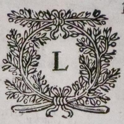
This letter L comes from the map of Leicestershire 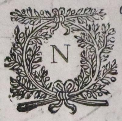
This letter N comes from the map of Northamptonshire 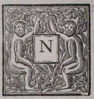
This letter N comes from the map of Nottinghamshire |
A popular edition published by Thomas Basset and Richard Chiswell. The impressions are lighter but the margins are usually wider than the previous editions. There were some specimens printed on a thick paper The English text on verso was reset for this edition, A number of interesting maps of North America and one of the Holy Land were added to the Prospect for this edition. 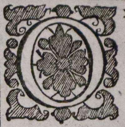
This letter O comes from the map of Oxfordhsire 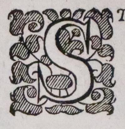
This letter S comes from the map of Staffordshire 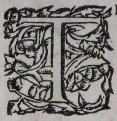
This letter T comes from the map of West Riding of Yorkshire |
||||||||||
circa 1690 - 95 |
A rare edition by Christopher Browne who erased the imprint of Bassett and Chiswell on the maps of Hampshire, Dorset, Devon, Cornwall, Somerset and Yorkshire and replaced it with "Christopher Browne, at the Globe near the West End of St. Paul's Church London". In the past 25 years we have only offered one complete series of these maps, featured in our Catalogue 14 in 1971. |
||||||||||
1710 - 43 |
An edition published by Henry Overton whose imprint appears on the maps. The roads, following Ogilby's survey, were engraved onto the old plates for this edition. Plain on verso. |
||||||||||
1770 |
A rare edition and the last edition published by Dicey & Co. Pale impressions. Plain on verso. |
THEATRE OF THE EMPIRE OF GREAT BRITAINE

List of Maps
British Isles
England and Wales
Saxon Heptarchy
Invasions of England and Wales (added in later editions)
Bedfordshire
Berkshire
Buckinghamshire
Cambridgeshire
Cheshire
Cornwall
Cumberland
Derbyshire
Devonshire
Dorsetshire
Durham
Essex
Gloucestershire
Hampshire
Herefordshire
Hertfordshire
Huntingdonshire
Holy Island, Farne Islands, Guernsey, Jersey
Isle of Man
Isle of Wight
Kent
Lancashire
Leicestershire
Lincolnshire
Norfolk
Northamptonshire
Northumberland
Nottinghamshire
Oxfordshire
Rutlandshire
Shropshire
Somersetshire
Staffordshire
Suffolk
Surrey
Sussex
Westmorland
Wiltshire
Warwickshire
Worcestershire
Yorkshire
Yorkshire West Riding
Yorkshire North and East Ridings
Wales
Anglesey
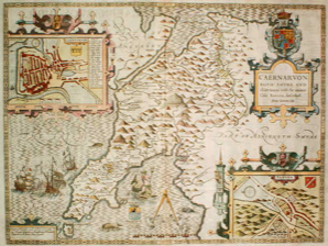
Caernarvonshire
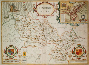
Denbighshire
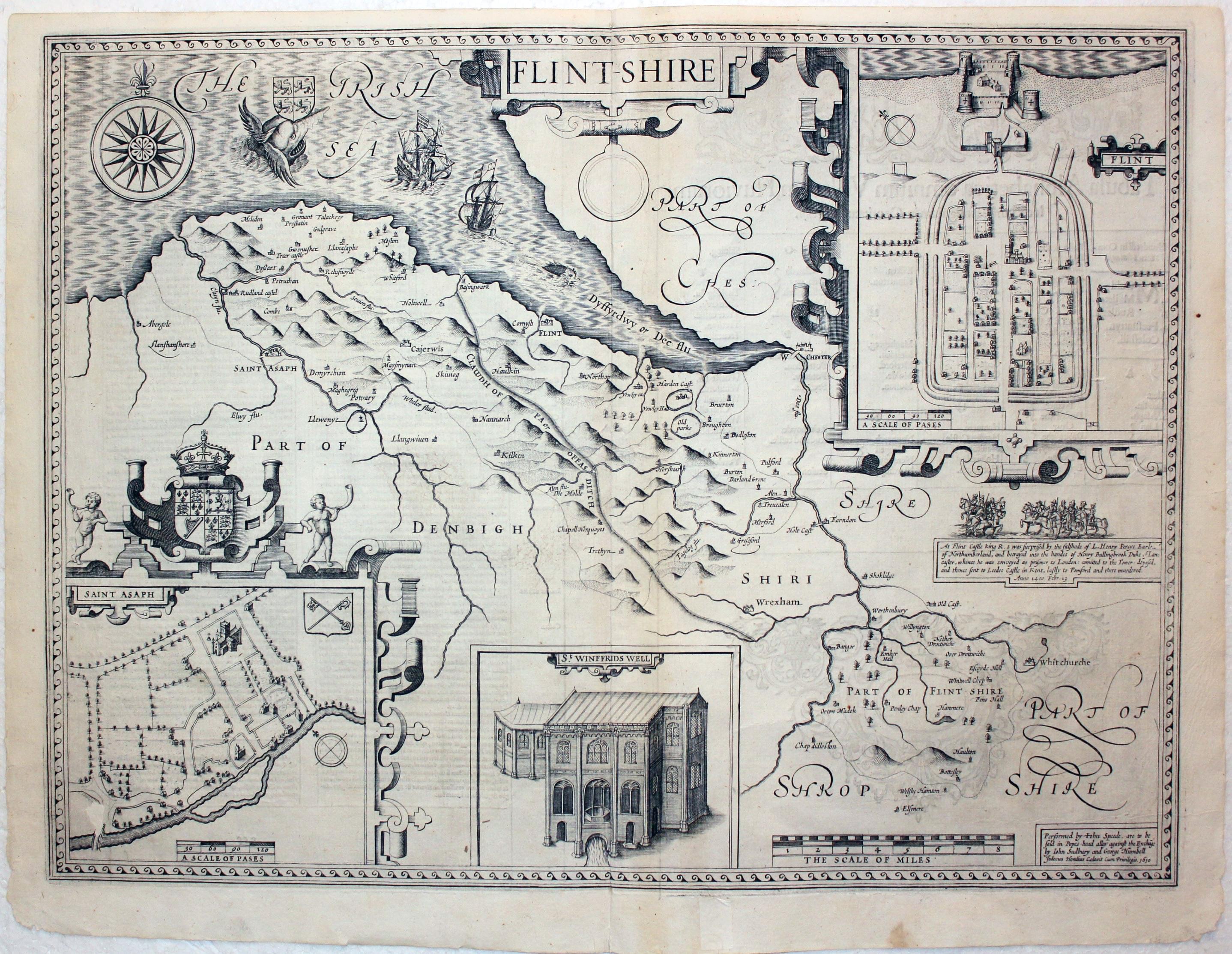
Flintshire
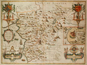
Merionethshire
Montgomeryshire
Breconshire
Cardiganshire
Carmarthenshire
Glamorganshire
Monmouthshire
Pembrokeshire
Radnorshire
Scotland
Ireland
Munster
Leinster
Connaught
Ulster

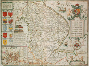
JOHN SPEED
Born in 1552 Died in 1629
The story of how stock of the London map trade was acquired or passed from one to another is a fascinating one. The relationships between surveyors, mapmakers, engravers, publishers and mapsellers is often complex. I hope the following helps to illustrate the history of John Speed's map plates and a few other relationships.
To begin be difficult to get your head round the fact that these wonderful 17th century maps were engraved by very talented engravers who wer able to produce a mirror image of the map.
John Sudbury
fl. 1599 - 1618
George Humble
(fl. 1603 - 40). Died in 1640
The business bequeathed to George Humble's Son.
William Humble
(fl. 1640 - 59)
Published many editions of the Speed Atlas
Peter Stent
fl. 1641 - 1662. Acquired stock from William Humble but not the Speed plates. Published the series of anonymous county maps in 1650. Died in 1665
William Garrett. Publisher
His daughter married John Overton
Purchased the Speed plates from William Humble in 1658 - 9. Did not use them but soon sold them to Roger Rea the elder and younger.
Roger Rea, the elder and the younger
(fl. 1660 - 67) Purchased the John Speed plates and published atlases in 1662 and 1665
Thomas Basset (fl. 1659 - 93) and Richard Chiswell (fl.1639 - 1711)
Purchased the Speed plates from Roger Rea and published an atlas in 1676
Christopher Browne
(fl. 1688 - 1712)
Purchased the Speed plates and published an atlas. Sold the Speed plates to John Overton.
John Overton (fl. 1665 - 1707)
Married the daughter of **William Garrett
Acquired stock of Peter Stent in 1665
Acquired Speed plates in 1700 from Christopher Browne. Disposed of his stock to his son Henry Overton in 1707.
Henry Overton (fl.1707 - 49)
Reissued the series of anonymous maps in 1708. Published Speed Atlas in 1713 and again in 1743
IILLUSTRATIONS
Cluer Dicey (fl. c.1740-0)
Acquired the Speed plates and published the last edition in 1770.
Hand Colouring
You may come across a few John Speed maps with colouring described as early. The publishers, however, did not advertise or sell the atlases coloured unlike some of the 17th century Dutch map publishers. No doubt you would have had to employ a colourist before the maps were bound into the atlas. The majority of John Speed maps arrived in the 20th century in an uncoloured state. Modern colouring is quite acceptable and many present day collectors like their John Speed maps to be coloured. There are those, however, who would prefer to have a specimen as it was when published. It is really a matter of personal taste. The quality of the modern hand colouring is in my opinion extremely important and poor unattractive modern colouring can greatly reduce the value. I have seen some very very poor modern hand colouring and it makes me despair. So many John Speed maps have been hand coloured in the last 90 years. Perhaps there will be a move by collectors to favour uncoloured specimens one day as they are condsidered to be rarer. Who knows.
Did you know that many of the coats of arms on John Speed's maps are colour coded?
If you look carefully at the coats of arms you will see small engraved letters on different parts. The letters were chosen from traditional mediavel French.
OR (Gold) is lettered O
Bleu (Blue) is lettered B
Gules (Red) is lettered G
Vert (Green) is lettered V
Argent (Silver) is lettered A
Purpure (Purple) is letterd P
-

Heraldic page from The Theatre of the Empire of Great Britaine

Division into Books
-
Portrait of John Speed
-

Titlepage for John Speed Theatre Book 4, 1616
-

Titlepage for John Speed Theatre Book 2, 1616
-

Titlepage for John Speed Theatre Book 3, 1676


-

Leinster by John Speed
-

Montgomeryshire by John Speed
-

Denbighshire by John Speed
-

Essex by John Speed
-

-

Surrey by John Speed
-

Cardiganshire by John Speed
-

Anglesey by John Speed
-

Map of Huntindonshire by John Speed
-

Yorkshire North and East Ridings by John Speed
-

Map of Flintshire by John Speed c.1710 with later hand colouring
-

Map of Nottinghamshire by John Speed, 1646
-

Map of North & East Ridings of Yorkshire by John Speed, 1646
-

Map of Bedfordshire by John Speed, 1646


Text on Verso of Maps
-

Yorkshire North and East Ridings John Speed text 1646
-

Merionehshire John Speed text 1646

List of Maps in the 1611 Edition of The Theatre of the Empire of Great Britaine
The First Booke
The Second Booke
-
Title Page Book 2 dated 1616
-

List of maps of Wales 1631 edition

The Third Booke

The Fourth Booke
FRONTISPIECES
-

John Speed Theatre Frontispiece 1676 engraved by Robert White
-

John Speed Theatre Frontispiece 1611
-

John Speed Theatre Frontispiece 1614
-

John Speed Theatre Frontispiece 1743 engraved by Robert White


The impressive engraved frontispiece makes a statement of great power and is a fitting start to The Theatre of the Empire of Great Britaine. It is interesting to note the slight changes in the new engraving by Robert White for the 1676 edition published by Thomas Basset and Richard Chiswell. The basic layout of the figures of a Roman, a Saxon, a Dane and a Norman remain. The title label is now arched instead of square and there are changes to the engravings on the plinth showing London and a sailing ship..
MAP PROOFS
Thirty-three of Speed's maps bear the signature of the engraver of the plates, Jodocus Hondius (1563-1612). The engraving took place in his studio in Amsterdam. Other maps may have been engraved by Abraham Goss but none bear his name. Speed must have spent much time gathering together material to produce the maps including drawings of buildings, antiquities, portraits and the unique town plans that were so cleverly woven into the design of each map by the engraver to produce a beautifully balanced piece of artwork.
It appears the the engraved plates were sent to London for printing where the text for the atlas was also printed. Proof impressions of the plates with no text on verso do exist. You may be lucky to find one of these one day. I have only two in my own collection, Caernarvonshire and Flintshire. There are a few sets in existence including the British Museum, Royal Geographical Society and Cambridge University Library.
There are 66 maps in the Cambridge University Library set. It is known as the Gardner set after the former owner Dr. Eric Gardner (1877 - 1951) These maps are viewable online in the Cambridge Digital Library
-

John Speed map of Flintshire Proof c.1611
-

John Speed map of Caernarvonshire Proof c.1611


RICHARD NICHOLSON of CHESTER COLLECTION
John Speed’s Theatre of the Empire of Great Britain published by Thomas Basset and Richard Chiswell in 1676
Do you know where your John Speed map has been all these years?
The answer to this question is probably no. You are the map's current custodian. You may know the previous owner should the map have been handed down to you but if your have bought it at an auction or from a dealer then you will probably not know. Having sold antique maps for some 60 years I might know who the last two owners are if it is a map I have sold sometime in the past. But to know the owners right back to the time the map was published in an atlas is indeed rare. I have this opportunity thanks to a man back in 1948 who set out on a blank page a list of previous owners at the back of his 1676 edtition of The Theatre of the Empire of Great Britaine published in London by Thomas Bassett and Richard Chiswell. This will not tell you the life story of your John Speed map but it might give you an understanding of what it might have been like.
History of this book from 1676 to 2025
I have to thank Arthur Bernard Chambre K. Keeves who in December 1948 had the foresight to put down in his own words on a blank page at the end of the atlas the line of ownership up until the time he came to be the owner.
- It was bought new by Richard Williams of Llangefni
- On his death he bequeathed it to his daughter Margaret who married an Edwards
- She left it to her daughter Mary Edwards who married John Williams of Anglesey
- It was again inherited by a daughter namely Elizabeth Williams who married William Wynne of Maes-y-neuadd. He was High Sherrif of Merionethshire in 1758 and in 1764 he assumed the surname of Nannay when he inherited the estate of his mother Lowry Nannay of Maes-y-Pandy. The book was for many years in the library at Maes-y-neuadd and was inherited by their eldest daughter Lowry Nannay Wynn
- This Lowry Nannay Wynn married Captain Thomas Vaughan of Plas Thomas, Denbigh and Burlton Hall in Shropshire in 1795 and the volume came to rest at Burlton.
- It was inherited by their only son Robert Chamber Vaughan (born 1786 - died 1876) who had it rebound about the year 1840.
- Robert Chambre Vaughan gave the book to his son Reverend Arthur Chicheley Chambre Vaughan (1834 - 1909) who was Rector of Ingram in Northumberland.
- On the death of Robert Chambre Vaughan in 1910 the volume was inherited by his surviving daughter Mary Dent Vaughan who married Bernard Keeves.
- Mary Keeves died on 8th March 1948 and the book came into the possession of their only child Arthur Bernard Chambre K. Keeves, a Captain in the Bengal Indian Amy Service Corps who is the present owner.
- The volume was purchased at a London auction by Richard Nicholson of Chester in the 1970’s.
-

John Speed map of Flintshire Proof c.1611
-

List of owners of a 1676 edition of John Speed's Theatre of the Empire of Great Britaine
-

John Speed's Prospect of the World title page 1676
-

John Speed Atlas Title Page 1676
-

Speed Dedication to the Monarch 1676
-

E Phillips dedication to Lord Mayor London 1676
-

Contents of John Speeds Theatre 1676


Modern Reproductions
There are modern reproductions of John Speed maps that the collector should be aware of. It is unlikely that once you have handled an original map by John Speed you will be caught out by these reproductions but do take care when purchasing framed maps as it is more difficult to see the features.
I get two or three telephone calls a month about John Speed maps from people who have found them in their loft or been left them. Very often they are from a series of reproduction maps that have been sold widely for many years. They are very easy to spot and usually I can answer a telephone callers concerns by a few questions, such as. What is the paper like that the maps are printed on? If the answer mentions parchment then the answer is simple. It is a modern reproduction of little or no value. The map has no text on the back and no centre fold and the overall colour of the paper is brown. These maps have been sold in their thousands. I remember seeing them back in the 1970's in stationers shops and perhaps Smiths, folded into paper wallets with a transparent panel on the front showing part of the map. The fold lines are usually still evident.
I do see these maps appearing in auction sales. One was catalogued John Speed, British, 1552-1629, Middle-sex described with the most famous Cities of London and Westminster; vignette to lower right reads 'Described by John Norden, Augmented by J Speed, Solde in Popes alley against the Exchange by George Humble', sheet size 35.5cm x 48cm, frame 45.5cm x 58cm
In heavily worn condition. Heavily stained dark brown throughout. Previously folded in four with prominent horizontal and vertical creases visible. Ruckling and undulation to the sheet. Has not been inspected out of the frame.
The auctioneer's estimate was £80- £120. Opening price - £30. To a map collector their value in my opinion is nil. I can only caution you with the words caveat emptor
Added 28th April 2025
It has been brought to my notice that I should mention another particular series of reproducton John Speed maps. This came about when a gentleman wrote to me recently about his John Speed map of Lincolnshire that he wished to sell. He said that he was not an expert on maps but had purchased this map some 35 years ago and had been assured by the dealer that is was an original John Speed map. Unfornunately I found that it was not an original.
In 1953 Pheonix House Ltd published a set of four volumes edited by John Arlot, the journalist, author and cricket commentator, containing a series of actual size colour printed reproduction John Speed maps with the text on verso from the first edition of 1610-11. These maps have a centre fold like original John Speed maps. The colours are somewhat flat but under glass these maps can deceive the uninitiated. When you have seen a number of specimens of this series of reproductions you will become, I hope, accustomed to the range of colours used. In 1974 the plates seem to have been used again by N. T. Leslie (RareBooks) 15 & 17 Hepworth's Arcade Silver Street, Hull to publish a single volume of the maps. These have no centre fold and no text on verso. These maps were not meant to deceive when they were published but in the intervening years they may have been used to deceive, knowingly or unknowingly. So again it is buyers beware.
I am illustrating four county maps from this series of reproduction maps below which I hope may be of some help. The rest is up to you.
-

1953 reproduction of John Speed's map of Middlesex
-

1953 reproduction of John Speed's map of Suffolk
-

1953 reproduction of John Speed's map of Norfolk
-

1953 reproduction of John Speed's map of Cumberland


So what to look out for when deciding if you have found an original or a reproduction Speed map
- Original maps were printed on laid paper. Reproductions are printed on a paper with a flat surface and having no character
- Original maps have a centre fold and evidence on verso of how the map was bound into the atlas
- Original maps were printed by an inked copper plate pressing onto the paper. You should be able to find evidence of the edge of the plate where it has left an indentation just outside the printed area. Reproductions will not have this as they are printed by modern technics and lithography
- Hold the map up to the light. You may see some watermarks but certainly lines showing it is hand made laid paper. Reproduction maps will have an all over similar texture and colour.
- Original John Speed maps were never printed on a paper that resembles parchment so that is a simple way to identify.
FARNDON TODAY
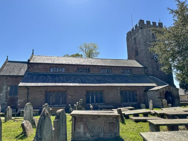
If you get the chance to visit the church of St. Chad's in the village of Farndon please do so. There is a usefull small car park down the lane by the church. As you enter the church through the large heavy front door, close it behind you for fear a squirrel might follow you in. And then look to your right and you will see a piece of wall remembering the great mapmaker. A notice tells you that John Speed was baptized here in 1552. Then take time to enjoy the peaceful atmosphere of this beautiful Anglican church.
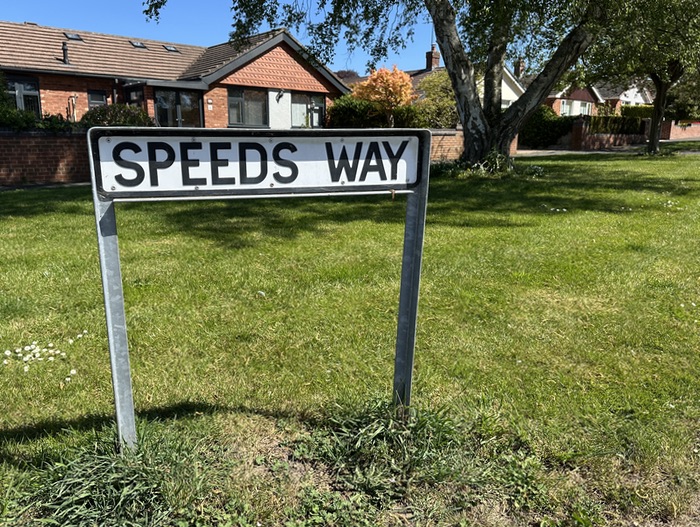
Not far away off Townfield Lane you will find Speeds Way. A most fitting way to remember this famous cartopgrapher born in the village so many years ago.

RICHARD NICHOLSON
of CHESTER
Stoneydale
Pepper Street
Christleton
Chester
CH3 7AG
Telephone
01244 336004
International 44 1244 336004

I have been buying and selling antique maps since the early 1960's during which time I had a gallery in Watergate Street, Chester for 30 years. I am now able to offer through my websites a personal service to map and print collectors.

