RICHARD NICHOLSON of CHESTER
A WORLD OF ANTIQUE MAPS AND PRINTS

The Cartographer
ROBERT MORDEN
Publisher, bookseller, mapseller, cartographer, globe and instrument maker
A popular series of county maps illustrating Camden's Britannia for many editions
Robert Morden was an English publisher, bookseller, mapseller, cartographer, globe and instrument maker. He worked in London at the Atlas in New Cheapside and at the Atlas in Cornhill from 1675 to 1703. His output in cartographical works was quite large and varied. It included geographical playing cards, large scale maps in a number of sheets, the most important being a 12 sheet plan of London by William Morgan.
He is probably best known for his series of county maps in Camden's Britannia. This work had last been published in 1637 and illustrated with county maps by William Hole and William Kip. The new edition was published in 1695 by Edmund Gibson, Bishop of Lincoln, printed by F. Collins for Abel Swalle at the West end of St. Paul's Church yard and for Awnsham and John Churchill at the Black Swan in Paternoster Row.
Gibson in the preface describes how the maps were prepared.
The Maps are all new engraved, either according to Surveys never before published, or according to such as have been made and printed since Saxton and Speed. Where actual Surveys could be had, the were purchased at any rate; and for the rest, one of the best Copies exant was sent to some of the most knowing Gentlemen in each County; with a request to supply the defects, rectified the positions, and correct the false spellings. An that nothing might be wanting to render them as complete and accurate as might be, this whole business was committed to MR. ROBERT MORDEN, a person of known abilities in these matters, who took care to revise them, to see the slips of the Engraver mended, and the corrections, returned out of the several Counties duly inserted. Upon the whole, we need not scruple to affirm, that they are much the fairest and most correct of any that have yet appeared.
There were four editions of Camden's Britannia illustrated with the county maps by Robert Morden.
- 1695. Paper thinner than the later editions. Margins small and cropping to the images is seen often.
- 1722. Thicker paper than the 1695 edition and wider blank margins. Most specimens I have seen have a watermark of a horse within a circle.
- 1753.
- 1772. Impressions a bit lighter. Most specimens I have seen have had wide blank margins.
Morden later produced in 1701 a series of smaller county maps often known as Miniature Mordens. These appeared in The New Description and State of England published jointly with Thomas Cockeril and Ralph Smith. There were further editions of these maps until 1738.

List of Maps in Camden's Britannia
- England
- Roman Britain
- Saxon Britain
- Cornwall
- Devonshire
- Dorsetshire
- Somersetshire
- Wiltshire
- Hampshire
- Berkshire
- Surrey
- Sussex
- Kent
- Gloucestershire
- Oxfordshire
- Buckinghamshire
- Bedfordshire
- Hertfordshire
- Middlesex
- Essex
- Suffolk
- Norfolk
- Cambridgeshire
- Huntingdonshire
- Northamptonshire
- Leicestershire
- Rutlandshire
- Lincolnshire
- Nottinghamshire
- Derbyshire
- Warwickshire
- Worcestershire
- Staffordshire
- Shropshire
- Cheshire
- Herefordshire
- South Wales
- Monmouthshire
- North Wales (Decorative cartouche on the 1695 edition map, replaced by a simple box on later editions of the atlas)
- Yorkshire West Riding
- Yorkshire East Riding
- Yorkshire North Riding
- Durham
- Lancashire
- Cumberland
- Westmorland
- Northumberland
- Scotland (Map of the whole country in the 1695 edition. Replaced by separate maps of North and South Scotland in later editions.)
- Ireland
- The Smaller Islands in the British Ocean
Illustrations - Camden's Britannia
-

Map of Devonshire by Rober Morden
-

Map of Shropshire by Robert Morden
-

Map of North Riding of Yorshire by Robert Morden
-

Map of Lincolnshire by Robert Morden
-

Map of Herefordshire by Robert Morden
-

Map of Essex by Robert Morden


Illustrations - Morden's Smaller Sized Maps
-

Titlepage to Description and State of England, Robert Morden 1701
-

For the reader of Description and State of England, Robert Morden 1701


-

Map of Derbyshire by Robert Morden 1701
-

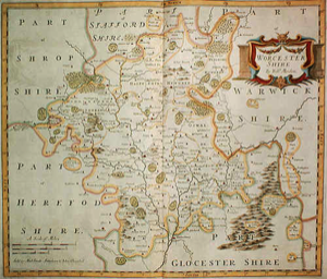
Map of Worcestershire by Robert Morden
-

Map of Worcestershire by Robert Morden
-

Map of Essex by Robert Morden 1701
-

Cambridgeshire by Robert Morden, 1701


Title Pages and Portrait
-

Robert Morden 1701 Titlepage
-

Portrait of William Camden engraved by R. White


Just my personal opinion
Forunately these maps are not rare. Thanks to them appearing as illustraions in a very popular historical work, Camden's Britannia. It sold a lot of copies in its day. So popular the work was republished many times over a period of years from the late 17th century to well on into the 18th century. For me this publication has been a mainstay in selling county maps over the years. It offers a good size, good age, detailed and reasonably priced. Therefore a very good start to a collection or as a gift. I have sold many specimens just because they appear to be good value. You might have to accept some small margins and trimming with the 1695 edition but later editions have much larger blank margins. Do not go for specmens with hideous modern colouring. There are many about. If you want a coloured specimen look for one that has been tastefully hand coloured with a pleasing palette of colours as well as carefully executed work.

RICHARD NICHOLSON
of CHESTER
Stoneydale
Pepper Street
Christleton
Chester
CH3 7AG
Telephone
01244 336004
International 44 1244 336004

I have been buying and selling antique maps since the early 1960's during which time I had a gallery in Watergate Street, Chester for 30 years. I am now able to offer through my websites a personal service to map and print collectors.

