RICHARD NICHOLSON OF CHESTER
A WORLD OF ANTIQUE MAPS AND PRINTS

A GUIDE TO COLLECTING MAPS
OF THE BRITISH ISLES
CHARLES II

1660 - 1685
Charles: The eldest surviving son of Charles I and Henrietta Maria of France
Born in London on 29th May 1630 Proclaimed king in May 1660, landing at Dover on the 25th His reign is known as the Restoration Period In 1677 Charles married his niece Mary to the Protestant William of Orange
King Charles I was born on November 19, 1600, in Dunfermline, Scotland. He became king of England, Scotland, and Ireland in 1625, succeeding his father, King James I.
Charles I's reign was marked by conflict with Parliament. He believed in the divine right of kings, which led to disputes over issues like taxation and religious reforms. His attempts to impose reforms and raise taxes without Parliament's consent led to the Petition of Right in 1628, which sought to limit the king's power. The disagreements with Parliament eventually escalated into the English Civil War in 1642. The war was fought between the supporters of the king, known as Cavaliers or Royalists, and those supporting Parliament, known as Roundheads or Parliamentarians.
The war ended in 1646 with a victory for the Parliamentarians. Charles was captured, tried for treason, and executed on January 30, 1649. His death marked the end of the monarchy, and England became a Commonwealth under the leadership of Oliver Cromwell. Charles I's execution was a significant event in British history as it was the first and only time a reigning monarch had been tried and executed by their own people. The monarchy was restored in 1660, and Charles's son, Charles II, became king.
JAMES II (VII OF SCOTLAND)

1685 - 1689
William: The son of William II, Prince of Orange Mary: The eldest daughter of Charles I
William was born at The Hague in 1650 Ascended the throne in 1689 Died at Kensington, London in 1702 Mary was born at St. James's Palace, London in 1662 Died at Kensington in 1694
King James II was born on October 14, 1633, in London, England. He became king of England and Ireland (as James II) and king of Scotland (as James VII) in 1685, succeeding his brother, King Charles II.
James II's reign was marked by conflict due to his Catholic faith in a predominantly Protestant country. His attempts to promote religious tolerance and appoint Catholics to high office led to opposition from the Protestant establishment.
This opposition culminated in the Glorious Revolution of 1688, when James was overthrown by his Protestant daughter Mary and her husband, William of Orange. James attempted to regain the throne in the Williamite War in Ireland, but he was defeated at the Battle of the Boyne in 1690.
After his defeat, James lived the rest of his life in exile in France. He died on September 16, 1701. His descendants, known as Jacobites, made several attempts to restore the Stuart dynasty to the British throne, but none were successful.
WILLIAM & MARY
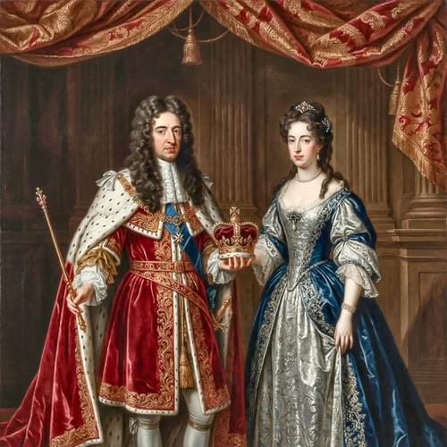
1689 - 1702
William: The son of William II, Prince of Orange Mary: The eldest daughter of Charles I
William was born at The Hague in 1650 Ascended the throne in 1689 Died at Kensington, London in 1702 Mary was born at St. James's Palace, London in 1662 Died at Kensington in 1694
King William III and Queen Mary II were joint monarchs of England, Scotland, and Ireland from 1689 to 1694, following the Glorious Revolution. Mary II was the eldest daughter of King James II. William of Orange, her husband, was a Dutch prince and Mary’s first cousin. In 1688, they were invited by Parliament to overthrow James II, whose Catholic rule and absolutist tendencies had caused widespread opposition.
After James fled England, William and Mary were crowned together, marking a unique joint monarchy. Their reign established the principle that the monarch ruled with Parliament’s consent, significantly strengthening constitutional government. Mary governed alone when William was abroad leading military campaigns, while William continued to rule after Mary’s death in 1694.
Their reign laid important foundations for Britain’s constitutional monarchy and Protestant succession.
QUEEN ANNE

1702 - 14
The second daughter of James II and AnneHyde William was born at The Hague in 1650 Born at St. James's Palace, London in 1665 Ascended the throne in 1702 Married George, Prince of Denmark Two sons and three daughters - twelve other children died soon after being born. Died at Kensington Palace in 1714
Queen Anne was born on February 6, 1665, in London, England. She became queen on March 8, 1702, following the death of her brother-in-law, King William III.
Anne's reign saw the union of England and Scotland into a single kingdom, the Kingdom of Great Britain, in 1707. This was a significant event, as it created a unified British Parliament and marked the beginning of a truly British national identity.
Anne's reign also saw the War of the Spanish Succession, a major European conflict in which Britain played a key role. The war ended with the Treaty of Utrecht in 1713, which expanded British territory and confirmed Britain's status as a major power.
Despite her political successes, Anne's personal life was marked by tragedy. She was pregnant 17 times, but none of her children survived into adulthood. Her only son to survive infancy, William, Duke of Gloucester, died at the age of 11. Anne's health declined in her later years, and she died on August 1, 1714. She was the last monarch of the House of Stuart, as she was succeeded by her second cousin, George I, of the House of Hanover.
GEORGE I

1714 - 1727
The son of Ernest Augustus, Elector of Hanover
Born at Hanover 18th March, 1660 Ascended the throne in 1714 Married Sophia Dorothea, Princess of Brunswick-Zell in 1682 Had one son and one daughter Died at Osnabruck in 1727 aged 67
King George I was born on May 28, 1660, in Hanover, Germany. He became king of Great Britain and Ireland on August 1, 1714, following the death of Queen Anne.
George's ascension to the throne marked the beginning of the Georgian era and the House of Hanover's rule in Britain. He was chosen as Anne's successor because he was the closest Protestant relative, despite more than 50 Catholics having a stronger hereditary claim.
George I's reign was marked by a shift in power from the monarchy to the cabinet government. As he spoke little English and was more interested in his German territories, he relied heavily on his ministers, particularly Sir Robert Walpole, who is often considered Britain's first Prime Minister.
George's reign also saw several Jacobite rebellions, attempts by supporters of the Catholic James Stuart (the "Old Pretender"), to regain the throne. However, all these rebellions were unsuccessful. George I died on June 11, 1727, during a trip to his native Hanover. He was succeeded by his son, George II.
RICHARD NICHOLSON
of CHESTER
Stoneydale
Pepper Street
Christleton
Chester
CH3 7AG
Telephone
01244 336004
International 44 1244 336004

I have been buying and selling antique maps since the early 1960's during which time I had a gallery in Watergate Street, Chester for 30 years. I am now able to offer through my websites a personal service to map and print collectors.

