RICHARD NICHOLSON OF CHESTER
A WORLD OF ANTIQUE MAPS AND PRINTS

A GUIDE TO COLLECTING MAPS
OF THE BRITISH ISLES
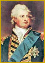
GEORGE IV

1820 - 1830
The eldest son of George III
Born at St. James's Palace, London on 12th August, 1762 Ascended the throne in 1820 Married Mrs. Maria Fitzherbert in 1785 and Caroline of Brunswick-Wolfenbutell in 1795 Had one daughter Died at Windsor on 26th June, 1830
King George IV was born on August 12, 1762, in London, England. He became king on January 29, 1820, following the death of his father, King George III. However, he had already been acting as Prince Regent since 1811 due to his father's mental illness. George IV's reign, particularly his early regency, was marked by elegance and achievements in the arts, which led to it being dubbed the Regency era. This period saw significant cultural and architectural advancements, including the building of the iconic Regency terraces and squares in cities like London and Brighton.
However, George IV's personal life was less successful. His marriage to Caroline of Brunswick was unhappy, and both were involved in public scandals. His extravagant lifestyle and heavy drinking led to health problems and earned him criticism. George IV's reign also saw several important political events, including the end of the Napoleonic Wars in 1815 and the passing of the Catholic Emancipation Act in 1829, which allowed Catholics to sit in the Parliament at Westminster.
George IV passed away on June 26, 1830, and was succeeded by his brother, William IV. His reign was a period of significant cultural achievement, but his personal life was marked by excess and controversy.
WILLIAM IV
1830 - 1837
The third son of George III
Born at Buckingham Palace on 21st August, 1765 Ascended the throne in 1830 Married Adelaide of Sax-Coburg and Meiningen in 1818 Had two daughters Died at Windsor on 20th June, 1837
King William IV was born on August 21, 1765, in Buckingham Palace, London. Before becoming king, he served in the Royal Navy and earned the nickname "Sailor King." William ascended to the throne on June 26, 1830,
William's reign saw several important reforms, including the Reform Act of 1832, which began the shift of political power from the aristocracy to the middle classes. His reign also saw the abolition of slavery throughout the British Empire in 1833.
Despite having ten illegitimate children with his longtime mistress, the actress Dorothea Jordan, William had no surviving legitimate children. His wife, Queen Adelaide, had several pregnancies, but none of their children survived infancy.
William passed away on June 20, 1837, and was succeeded by his niece, Queen Victoria. His reign was relatively short, lasting just under seven years, but it was a period of significant change in British society.
VICTORIA

1837 - 1901
The daughter of Edward, Duke of Kent and Victoria Maria Louisa of Saxe-Coburg
Born at Kensington Palace, London 24th May, 1819 Ascended the throne in 1837 Married Prince Albert of Saxe-Coburg in 1840 Had four sons and five daughters Died at Osborne, Isle of Wight on 22nd January , 1901
Queen Victoria was born on May 24, 1819, in Kensington Palace, London. She became queen at the age of 18, following the death of her uncle, King William IV, on June 20, 1837.
Victoria's reign, known as the Victorian era, was a period of significant change in the UK. It was marked by industrial, cultural, political, scientific, and military changes, and the UK was transformed into one of the world's leading industrial and imperial powers.
In 1840, Victoria married her first cousin, Prince Albert of Saxe-Coburg and Gotha. They had nine children, who married into various European royal families. Prince Albert's death in 1861 was a devastating blow to Victoria, and she entered a period of deep mourning and withdrew from public life. Victoria's Golden and Diamond Jubilees, celebrated in 1887 and 1897 respectively, were times of public celebration and reflection on her long reign.
Victoria was the longest-reigning British monarch until she was surpassed by her great-great-granddaughter, Queen Elizabeth II, in 2015. She passed away on January 22, 1901, and was succeeded by her eldest son, who became King Edward VII.
RICHARD NICHOLSON
of CHESTER
Stoneydale
Pepper Street
Christleton
Chester
CH3 7AG
Telephone
01244 336004
International 44 1244 336004

I have been buying and selling antique maps since the early 1960's during which time I had a gallery in Watergate Street, Chester for 30 years. I am now able to offer through my websites a personal service to map and print collectors.

