RICHARD NICHOLSON of CHESTER
A WORLD OF ANTIQUE MAPS AND PRINTS
The Cartographers
THOMAS KITCHIN and THOMAS JEFFERYS
THE SMALL ENGLISH ATLAS


1749 saw the publication of The Small English Atlas
with a series of English county maps by Thomas Kitchin and Thomas Jeffreys.
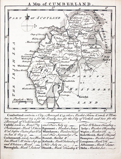
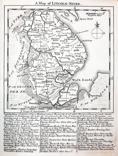
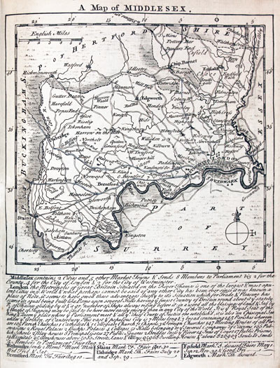
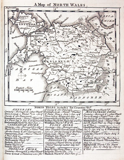
A delightful 8vo atlas for the 18th century traveller. The maps have a distinctive style with a panel of text beneath which gives a brief description of the county followed by a list of the main towns with details of Members of Parliament, Fairs and Market Days. No doubt a popular atlas in its day, first published in 1749 and again in 1751. More editions in 1775, 1785 1787 and the final edition published by Laurie and Whittle in 1794. with a reissue in 1796.
All the maps illustrated below have been photographed from a copy of the atlas in my collection. The maps are all uncoloured but you will come across specimens where the map has early outline hand colouring and in some cases wash colouring as well.
Map Gallery
-

Small English Atlas titlepage 1749
-

Small English Atlas preface 1749
-

England and Wales Counties by Kitchin & Jefferys 1749
-

England and Wales Direct Roads by Kitchin & Jefferys 1749
-

Bedfordshire by Thomas Kitchin and Thomas Jeffereys 1749
-

Berkshire by Thomas Kitchin and Thomas Jeffereys 1749
-

Buckinghamshire by Thomas Kitchin and Thomas Jeffereys 1749
-

Cambridgeshire by Thomas Kitchin and Thomas Jeffereys 1749
-

Cheshire by Thomas Kitchin and Thomas Jeffereys 1749
-

Cornwall by Thomas Kitchin and Thomas Jeffereys 1749
-

Cumberland by Thomas Kitchin and Thomas Jeffereys 1749
-

Derbyshire by Thomas Kitchin and Thomas Jeffereys 1749
-

Devonshire by Thomas Kitchin and Thomas Jeffereys 1749
-

Dorsetshire by Thomas Kitchin and Thomas Jeffereys 1749
-

County Durham by Thomas Kitchin and Thomas Jeffereys 1749
-

Essex by Thomas Kitchin and Thomas Jeffereys 1749
-

Gloucestershire by Thomas Kitchin & Thomas Jeffereys 1749
-

Hampshire by Thomas Kitchin and Thomas Jeffereys 1749
-

Herefordshire by Thomas Kitchin & Thomas Jeffereys 1749
-

Hertfordshire by Thomas Kitchin and Thomas Jeffereys 1749
-

Lincolnshire by Thomas Kitchin and Thomas Jeffereys 1749
-

Middlesex by Thomas Kitchin and Thomas Jeffereys 1749
-

Northamptonshire by Thomas Kitchin and Thomas Jeffereys 1749
-

Monmouthshire by Thomas Kitchin and Thomas Jeffereys 1749
-

Northumberland by Thomas Kitchin and Thomas Jeffereys 1749
-

Nottinghamshire by Thomas Kitchin and Thomas Jeffereys 1749
-

Map of Oxfordshire by Thomas Kitchin and Thomas Jeffereys 1749
-

Rutlandshire by Thomas Kitchin and Thomas Jeffereys 1749
-

Shropshire by Thomas Kitchin & Thomas Jeffereys 1749
-

Somersetshire by Thomas Kitchin and Thomas Jeffereys 1749
-

Staffordshire by Thomas Kitchin and Thomas Jeffereys 1749
-

Suffolk by Thomas Kitchin and Thomas Jeffereys 1749
-

Surrey by Thomas Kitchin and Thomas Jeffereys 1749
-

Sussex by Thomas Kitchin and Thomas Jeffereys 1749
-

Map of Warwickshire by Thomas Kitchin and Thomas Jeffereys 1749
-

Map of Westmorland by Thomas Kitchin and Thomas Jeffereys 1749
-

Map of Wiltshire by Thomas Kitchin and Thomas Jeffereys 1749
-

Worcestershire by Thomas Kitchin and Thomas Jeffereys 1749
-

Yorkshire by Thomas Kitchin and Thomas Jeffereys 1749
-

Yorkshire East Riding by Thomas Kitchin & Thomas Jeffereys 1749
-

Yorkshire North Riding, Thomas Kitchin & Thomas Jeffereys 1749
-

Yorkshire West Riding by Thomas Kitchin & Thomas Jeffereys 1749
-

North Wales by Thomas Kitchin and Thomas Jeffereys 1749
-

South Wales by Thomas Kitchin & Thomas Jeffereys 1749
-

Jersey and Guernsey by Thomas Kitchin & Thomas Jeffereys 1749
-

Map of Isle of Man by Thomas Kitchin & Thomas Jeffereys 1749
-

Scilly Isles by Thomas Kitchin & Thomas Jeffereys 1749
List of Maps in the Atlas
- A Map of England and Wales
- A Map of All the Direct Roads Through England and Wales
- A Map of Bedfordshire
- A Map of Berk-Shire
- A Map of Buckinghamshire
- A Map of Cambridgeshire
- A Map of Cheshire
- A Map of Cornwall
- A Map of Cumberland
- A Map of Derbyshire
- A Map of Devonshire
- A Map of Dorsetshire
- A Map of the Bishoprick of Durham
- A Map of Essex
- A Map of Glocestershire
- A Map of Hampshire
- A Map of Hereford-Shire
- A Map of Hertfordshire
- A Map of Huntingdonshire
- A Map of Kent
- A Map of Lancashire
- A Map of Leicestershire
- A Map of Lincoln-shire
- A Map of Middlesex
- A Map of Monmouthshire
- A Map of Norfolk
- A Map of Northamptonshire
- A Map of Northumberland
- A Map of Nottinghamshire
- A Map of Oxfordshire
- A Map of Rutlandshire
- A Map of Shrop Shire
- A Map of Somersetshire
- A Map of Staffordshire
- A Map of Suffolk
- A Map of Surrey
- A Map of Sussex
- A Map of Warwickshire
- A Map of Westmoreland
- A Map of Wilt Shire
- A Map of Worcestershire
- A Map of York Shire
- A Map of the East Riding of Yorkshire
- A Map of the North Riding of Yorkshire
- A Map of the West Riding of Yorkshire
- A Map of North Wales
- A Map of South Wales
- The Islands of Jersey, Guernsey &c.
- A Map of the Isle of Man
- A Map of the Isles of Scilly
Editions of the Atlas
| Atlas | Date | Publisher / Cartographer |
|---|---|---|
| The Small English Atlas | 1749 | Kitchin / Jefferys |
| do. | 1755 | Kitchin / Jefferys |
| do. | 1785 | Sayer |
| An English Atlas | 1787 | Sayer |
| do. | 1794 | Laurie & Whittle |


