RICHARD NICHOLSON of CHESTER
A WORLD OF ANTIQUE MAPS AND PRINTS

The Cartographer
CHRISTOPHER SAXTON
The 16th century cartographer who produced the first county atlas of maps of England and Wales during the reign of Queen Elizabeth I
1579
He produced the very first printed county maps of England and Wales. Some counties are grouped with others on a folio sheet.
List of Maps in the Atlas
ENGLAND
1 England and Wales
2 Cheshire
3 Cornwall
4 Derbyshire
5 Devonshire
6 Dorsetshire
7 Durham
8 Essex
9 Gloucestershire
10 Hampshire
11 Herefordshire
12 Hertfordshire
13 Kent, Sussex, Surrey and Middlesex
14 Lancashire
15 Lincolnshire and Nottinghamshire
16 Norfolk
17 Northamptonshire, Bedfordshire, Cambridgeshire, Huntingdonshire and Rutlandshire
18 Northumberland
19 Oxfordshire, Buckinghamshire and Berkshire
20 Shropshire
21 Somersetshire
22 Staffordshire
23 Suffolk
24 Warwickshire and Leicestershire
25 Westmorland and Cumberland
26 Wiltshire
27 Worcestershire
28 Yorkshire
WALES
29 Anglesey and Caernarvonshire
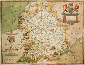
30 Denbighshire and Flintshire
31 Glamorganshire
32 Monmouthshire
33 Montgomeryshire and Merionethshire
34 Pembrokeshire
35 Radnorshire, Breconshire, Cardiganshire and Carmarthenshire
GALLERY
-

Caernarvonshire by Christopher Saxton c.1580
-

Denbighshire and Flintshire by Christopher Saxton c.1580


RICHARD NICHOLSON
of CHESTER
Stoneydale
Pepper Street
Christleton
Chester
CH3 7AG
Telephone
01244 336004
International 44 1244 336004

I have been buying and selling antique maps since the early 1960's during which time I had a gallery in Watergate Street, Chester for 30 years. I am now able to offer through my websites a personal service to map and print collectors.

