RICHARD NICHOLSON OF CHESTER
A WORLD OF ANTIQUE MAPS AND PRINTS

A GUIDE TO COLLECTING MAPS
OF THE BRITISH ISLES
ELIZABETH I

1558 - 1603
The daughter of Henry VIII and his second wife Anne Boleyn
Born at Greenwich Palace, London in 1533 Ascended the throne in 1558 Did not marry Died at Richmond in 1603, aged 70
Queen Elizabeth I was born on September 7, 1533, in Greenwich, England. She was the daughter of King Henry VIII and his second wife, Anne Boleyn. After the execution of her mother when Elizabeth was just two years old, she had a somewhat troubled childhood.
Elizabeth ascended to the throne on November 17, 1558, following the death of her half-sister, Queen Mary I. Her reign is often referred to as the Elizabethan era and is known for the flourishing of English drama, led by playwrights such as William Shakespeare and Christopher Marlowe.
Elizabeth's reign was also marked by several military and political challenges, including the Spanish Armada in 1588. Despite these challenges, she successfully maintained relative peace and stability in England.
Elizabeth never married or had children, earning her the nickname "The Virgin Queen." Her death on March 24, 1603, marked the end of the House of Tudor, a royal house of Welsh origin that had ruled England since 1485. She was succeeded by her cousin, James VI of Scotland, who became James I of England.
JAMES I (VI of SCOTLAND)

1602 - 25
The son of Mary, Queen of Scots and Henry, Lord Darnley
Born at Edinburgh Castle in 1566 Ascended the throne in 1603 Married Anne of Denmark Had three sons and four daughters Died at Theobalds in 1625, aged 59
King James I was born on June 19, 1566, in Edinburgh Castle, Scotland. Before becoming King of England, he was James VI of Scotland, ascending to the Scottish throne at just 13 months old after his mother, Mary, Queen of Scots, was forced to abdicate.
James became King of England and Ireland as James I on March 24, 1603, following the death of Queen Elizabeth I. This made him the first monarch to rule both England and Scotland, and his reign was known as the Jacobean era. One of the most significant events of his reign was the Gunpowder Plot of 1605, a failed assassination attempt by a group of English Catholics who planned to blow up the House of Lords during the State Opening of Parliament.
James is perhaps best known for commissioning the King James Bible, a translation of the bible into English that was completed in 1611. This version of the Bible remains one of the most popular and widely used in the English-speaking world. James's reign was also marked by a belief in the divine right of kings, which led to conflicts with Parliament. He died on March 27, 1625, and was succeeded by his son, Charles I.
CHARLES I
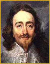
1625 - 1649
The second son of James I and Anne of Denmark
Born on 19th November, 1600 in the Palace Buildings at Rosyth Married Henrietta Maria Had two children - Charles II of England and James II of England Died by execution at the Palace of Whitehall on 30th January 1649
King Charles I was born on November 19, 1600, in Dunfermline, Scotland. He became king of England, Scotland, and Ireland in 1625, succeeding his father, King James I.
Charles I's reign was marked by conflict with Parliament. He believed in the divine right of kings, which led to disputes over issues like taxation and religious reforms. His attempts to impose reforms and raise taxes without Parliament's consent led to the Petition of Right in 1628, which sought to limit the king's power. The disagreements with Parliament eventually escalated into the English Civil War in 1642. The war was fought between the supporters of the king, known as Cavaliers or Royalists, and those supporting Parliament, known as Roundheads or Parliamentarians.
The war ended in 1646 with a victory for the Parliamentarians. Charles was captured, tried for treason, and executed on January 30, 1649. His death marked the end of the monarchy, and England became a Commonwealth under the leadership of Oliver Cromwell.
Charles I's execution was a significant event in British history as it was the first and only time a reigning monarch had been tried and executed by their own people. The monarchy was restored in 1660, and Charles's son, Charles II, became king.
CROMWELLIAN PERIOD

1649 - 1660
Born at Huntingdon in 1599
Dictator from 1653 to 1658
Oliver Cromwell was born on April 25, 1599, in Huntingdon, England. He came from a middle-class background and was relatively unknown until his 40s. Cromwell became involved in national affairs when he was elected Member of Parliament for Huntingdon in the English Parliament in 1628. He was a devout Puritan and strongly opposed the policies of King Charles I, particularly those related to religious freedom.
When the English Civil War broke out in 1642, Cromwell raised a cavalry troop and joined the Parliamentary forces fighting against the king. He proved to be an effective military leader and played a key role in the defeat of the Royalists.
Following the war, Cromwell was one of the signatories on King Charles I's death warrant, leading to the king's execution in 1649. England then became a republic known as the Commonwealth, and Cromwell became its leader, taking the title Lord Protector in 1653. Cromwell's rule was marked by strict Puritan morality and significant military and political reforms. However, his suppression of the Irish and Scottish populations has been widely criticized.
Cromwell died on September 3, 1658. His son, Richard, succeeded him as Lord Protector, but the Commonwealth collapsed in 1660, and the monarchy was restored with King Charles II.
RICHARD NICHOLSON
of CHESTER
Stoneydale
Pepper Street
Christleton
Chester
CH3 7AG
Telephone
01244 336004
International 44 1244 336004

I have been buying and selling antique maps since the early 1960's during which time I had a gallery in Watergate Street, Chester for 30 years. I am now able to offer through my websites a personal service to map and print collectors.

