Antique Maps of South Wales
Richard Nicholson of Chester

Established in 1961
A World of Antique Maps and Prints

The maps on this page are guaranteed to be genuine early specimens published in or around the year stated
19th Century - Shows the Railways
-

Cardigan, Pembroke and Camarthenshire, John Bartholomew, c.1898

29860 Cardigan, Pembrokeshire and Camarthenshire, John Bartholomew, c.1898. Price: 14.00
SECTION XV. CARDIGAN
A colour printed map showing parts of Cardiganshire, Pembrokeshire and Carmarthenshire. Scale of 4 miles to the inch. Shows the railways. 16 1/2 x 12 1/2 inches. Good clean condition.
From: The Royal Atlas
19th Century
-

Parts Pembrokeshire and Glamorganshire, John Bartholomew, c.1898

29857 Parts Pembrokeshire and Glamorganshire, John Bartholomew, c.1898. Price: 14.00
SECTION XX. PEMBROKE
A colour printed map showing part of Pembrokeshire and the Gower Peninsular. Scale of 4 miles to the inch. Shows the railways. 16 1/2 x 12 1/2 inches. Good clean condition.
From: The Royal Atlas
19th Century - Early Hand Colouring
-

West Wales, F. P. Becker, c.1842

29952 West Wales, F. P. Becker, c.1842. Price: 19.00
WALES - WEST
A clearly engraved map showing part of Cardiganshire and Merionethshire with the coast from Barmouth to Cardigan. Drawn by F. P. Becker & Co. 12 Paternoster Row. Engraved on Steel by the Omnigraph, F. P Becker. 13 1/2 x 10 3/4 inches. Original outline hand colouring. Good condition.
This map has just been taken from the atlas and therefore not sold as a single map before.
From: Fishers County Atlas of England and Wales Compiled from Authentic Surveys and Corrected to the Present Time with Geographical and Statistical Description of each County
19th Century - Early Hand Colouring
-

South Wales, John and Charles Walker 1851

30253 Part of South Wales, John and Charles Walker, 1851. Price: 35.00
SOUTH WALES
An engraved map showing Pembrokeshire with parts of of Carmarthenshire, Cardiganshire and Glamorganshire. Title panel and scale. List of boroughs with returning members. 12 1/2 x 15 1/4 inches. Original outline and wash hand colouring. Imprint of Longman, Rees, Orme, Browne & Co. beneath. Good clean condition on stout paper. A nice specimen. This map has been taken from the atlas and not been offered before as a single map.
From: The British Atlas
19th Century - Early Hand Colouring
-

South Wales, John Cary 1793

31074 South Wales, John Cary 1793. Price: 44.00
SOUTH WALES
A good detailed engraved map. Title panel and compass rose combined. Cary's imprint beneath dated 1793. 10 1/4 x 8 1/4 inches. Centre fold. Old manuscript numbering in blank margin 196 and 197. Original outline hand colouring. Good condition.
From: Cary’s New and Correct English Atlas
Title page and Annotated Contents Page
-

New and Correct English Atlas
-

Hobsons Fox Hunting Atlas List of Hunts


19th Century
-

Pembrokeshire and Glamorganshire, John Bartholomew c.1898

31243 Part of Pembrokeshire and Glamorganshire. John Bartholomew, c.1898. Price: 12.50
SECTION XX PEMBROKE
A colour printed map showing parts of Pembrokeshire and Glamorganshire. Scale of 4 miles to the inch. Shows the railways. 16 1/2 x 12 1/2 inches. Centre fold as issued. Good clean condition.
From: The Royal Atlas
19th Century
-

Breconshire and Radnorshire, John Bartholomew c.1898

31244 Part of Radnorshire, Breconshire, Herefordshire. John Bartholomew, c.1898. Price: 12.50
SECTION XVI RADNOR
A colour printed map showing parts of Radnorshire, Cardiganshire, Breconshire, Shropshire and Herefordshire. Scale of 4 miles to the inch. Shows the railways. 16 1/2 x 12 1/2 inches. Centre fold as issued. Good clean condition.
From: The Royal Atlas
For the Collector
-

South Wales, Carington Bowles, 1785

31456 South Wales, Carington Bowles, 1785. Price: 116.00
BOWLES’S NEW MEDIUM MAP OF SOUTH WALES DIVIDED INTO ITS COUNTIES AND SUBDIVIDED INTO ITS HUNDREDS ..
A good detailed late 18th century map of the region. The title appears within a circular panel bearing the imprint of Carington Bowles No. 69 in St. Paul’s Church Yard. Beneath the map is a further imprint Published as the Act directs, 3 Jan. 1785. Around the map are interesting engraved notes pertaining to the county. 12 1/2 x 8 3/4 inches. Explanation and scale. Original outline hand colouring. Superb clean condition having been taken straight from the atlas and not sold previously as a single map.
From: Bowles’s New Medium English Atlas The maps in this atlas are based on the maps by Emanuel and Thomas Bowen in their Atlas Anglicanus. The title cartouche has been changed as well as the addition of the distance in miles from London shown by some town names.
19th Century
-

Cardigan, Pembroke and Camarthenshire, John Bartholomew, c.1898

31500 Cardigan, Pembroke and Camarthenshire, John Bartholomew, c.1898. Price: 14.00
SECTION XV. CARDIGAN
A colour printed map showing parts of Cardiganshire, Pembrokeshire and Carmarthenshire. Scale of 4 miles to the inch. Shows the railways. 16 1/2 x 12 1/2 inches. Good clean condition.
From: The Royal Atlas
Late 18th Century - Early Hand Colouring
-

Map of South Wales John Cary, 1792

32584 South Wales, John Cary, 1792. Price: 12.00
SOUTH WALES
A small engraved map showing South Wales divided into counties.Tile panel surmounted by half compass rose. Panel at bottom with list of distances from London. Publisher’s imprint beneath dated 1792. 3 1/2 x 4 3/4 inches. Thin paper. Original outline hand colouring. Good condition.
From: Cary’s Traveller’s Companion
Titlpage dated 1791, maps dated 1792. The atlas was formerly in the Mumbee family library - title page stamped V. Munbee
Provenance
-

Cary Titlepage and Munbee Bookplate


Early 19th Century
-

Map of South Wales John Cary & John Stockdale 1808

33122 South Wales, John Cary and John Stockdale, c.1808. Price: 58.00
A MAP OF SOUTH WALES FROM THE BEST AUTHORITIES
A good detailed map of the county with publisher’s imprint dated 1805. 20 1/2 x 15 3/4 inches. A few small worm holes in the bottom blank margin otherwise good clean condition with wide blank margins. Originally bound on edge so there is no centre fold but there is a light fold crease up the centre of the map. Later hand colouring.
From: New British Atlas published by John Stockdale, Piccadilly.
18th Century - First Edition
-

South Wales Robert Morden 1695

33510 South Wales, Robert Morden 1695. Price: 40.00
SOUTH WALES BY ROBT. MORDEN
An engraved map of South Wales divided into counties. Decorative title cartouche and two scales. 16 x 14 inches, 425 x 355 mm. Uncoloured. Trimming to the two side printed borders which is often found with the first edition. Two inch split at the bottom of the centre fold. Otherwise nice clean condition.
From Camden's Britannia.
Antique Maps of Wales by John Booth
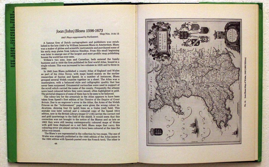
If you are a collector of Welsh antique maps and are looking for a good reference book then I would certainly recommend Antique Maps of Wales by John Booth. Mine is the first edition limited to 1,000 copies published in 1977 but there are later editions you could try and pick up. The main mapmakers are arranged chronologically and there is a good full page illustration to go with each.


RICHARD NICHOLSON
of CHESTER
Stoneydale
Pepper Street
Christleton
Chester
CH3 7AG
Telephone
01244 336004
International 44 1244 336004

I have been buying and selling antique maps since the early 1960's during which time I had a gallery in Watergate Street, Chester for 30 years. I am now able to offer through my websites a personal service to map and print collectors.

