18th Century Road Maps
John Owen & Emanuel Bowen
Richard Nicholson of Chester
A World of Antique Maps and Prints

Established in 1961
The maps on this page are guaranteed to be genuine early specimens published in or around the year stated
John Owen and Emanuel Bowen
1720 - 1764

A series of early 18th century county maps and road maps. The maps are double sided. For the county maps available please refer to the county listings of maps.
Each measures about
4 3/4 x 7 1/4 inches
A series of early 18th century county maps and road maps. The maps are double sided. Some have a county map on one side and a road map on the reverse side. Others have a road map on both sides.
For the county maps available please refer to the county listings of maps.
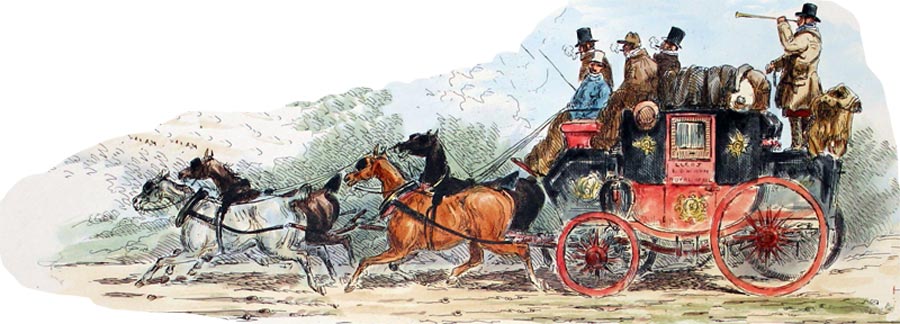
These delightful and fascinating small road maps with their embellishments of coats of arms and historical notes come from an 18th century road atlas - Britannia Depicta. The strip road maps of England and Wales first appeared in 1675 with the publishing of John Ogilby's magnificent atlas Britannia, containing 100 folio sized road maps. By the first part of the 18th century there was public demand for a small road atlas that could be easily carried by travellers on horseback or for those who could afford to take a coach. There were a number of abortive attempts to produce such a handy sized atlas but others succeeded like John Senex who published his small road atlas in 1719. A year later Britannia Depicta was published by Thomas Bowles. The interesting notes that appear on the front and back of each map were compiled by the antiquarian and lawyer John Owen whilst the engraving was undertaken by Emanuel Bowen This was Bowen's first major work as a cartographical engraver for which he received a part share in the atlas in payment for his labours. The format of the atlas and maps met with the public's approval and the atlas was republished many times over the next forty years until the last edition in 1764. The double sided Road Maps each measure about 5 x 7 inches.

1/2 CARDIGANSHIRE. / London, Uxbridge, Beaconsfield
3/4 High Wycombe, Tetsworth, Oxford, Islip. Islip, Enston, Morton Broadway.
5/6 Broadway, Pershore, Worcester, Bramyard. / Bramyard Leominster, Presteign.
7/8 Rhayader, Aberystwyth. SUSSEX
9/10 London, Ewell, Leatherhead, Dorking / Billingshurst, Amberley.
11/12 NOTTINGHAMSHIRE. London, Ware, Puckridge.
13/14 Royston, Huntingdon Stilton/Stilton, Stamford.
15/16 Grantham, Newark, Tuxford? Tuxford, Bawtry, Doncaster.
17/18 Wentbridge, Ferrybridge, Tadcaster, York/ York Boroughbridge, North Allerton.
19/20 Darlington, Durham, Chester le Street/Newcastle Morpeth.
21/22 Alnwick, Berwick. MIDDLESEX.
23/24 London, Hounslow, Maidenhead, Reading/Newbury, Hungerford, Marlborough.
25/26 Marlborough, Chippenham, Marshfield/Bristol Axbridge,Huntspil
27/28 NORTHAMPTONSHIRE. London, Uxbridge, Amersham, Missenden.
29/30 Wendover, Aylesbury, Buckingham, Banbury/Banbury Stratford, Caughton
31/32 Bromsgrove, Kidderminster, Bridgnorth. Banbury, Campden. GLAMORGANSHIRE
33/34 London, Brentford, Hounslow Slough/ Maidenhead, Henley, Dorchester,, Abingdon
35/36 Abingdon, Faringdon, Lechlade / Gloucester Monmouth
37/38 Monmouth, Newport, Cardiff/Llandaff, Cowbridge, Burton
39/40 Burton, Swansea,Llanelly, Kidwelly Haverfordwest,St Davids
41/42 London, Deptford,Dartford, Rochester, Rainham. Description of London on verso
43/44 Sittingbourne, Canterbury, Dover. Part of an Description of London on verso
45/46 London, Romford, Chelmsford, Kelvedon, Colchester, Harwich.
47/48 London, Eltham, Farningham, Wrotham. Part of a description on verso
49/50 Maidstone, Ashford, Hythe. ANGLESEY.
51/52 London, High Barnet, St. Albans, Dunstable, Stony Stratford,Towcester
53/54 Towcester, Daventry, Dunchurch, Coventry, Coleshill, Lichfield
55/56 Lichfield, Rugeley, Stone, Darleston, Nantwich, Tarporley, Chester
57/58 Chester, Hawarden, Northop, Denbigh, Conway Beaumaris, Holyhead
59/60 London, Brentford, Hounslow, Staines, Bagshot. Description of London on verso.
61/62 Basingstoke, Andover, Salisbury.
63/64 Shaftesbury, Sherborne, Crewkerne, Axminster, Exeter, Chidley
65/66 Ashburton, Plymouth, Looe, Foy, Tregony
67/68 Golsenna, Penzance, Lands End. Part of a description of London on verso
69/70 Southwark, Stretham, Croydon, East Grinstead, Newhaven, Brighton, New Shoreham.
71/72 London, Wandsworth, Kingston, Guildford. Godalming Description of London on verso.
73/74 Lippock, Petersfield, Portsmouth, London, Bromley, Sevenoaks, Tunbridge
75/76 Lamberhurst, Newenden, Rye. Part of a description of London on verso.
77/78 Andover, Amesbury, Warminster. Part of a description on London on verso.
79/80 Bruton, East Lidford, Bridgwater, Dulverton
81/82 South Moulton, Barnstaple, Torrington, Hatherleigh, Launceston, Camelford
83/84 Padstow, Columb, Truro, Part of a description of London on verso.
85/86 Chippenham, Bath Wells, Marlborough, Devises, Trowbridge, Wells
87/88 Stilton, Peterborough, Crowland, Spalding Part of a description of London on verso.
89/90 Boston, Sleaford, Lincoln. STAFFORDSHIRE.
91/92 Darleston Bridge, Newcastle under Lyme, Warrington, Wigan, Whittle, Preston Garstang
93/94 Garstang, Lancaster, Bolton, Kendal, Penrith, Carlisle
95/96 SURREY. Guildford, Godalming, Midhurst, Chichester.
97/98 Midhurst, Petersfield, Winchester. DERBYSHIRE.
99/100 Stony Stratford, Northampton, Market Harborough, Leicester, Loughborough, Derby
101/102 Tamesford, Eaton, Stilton, Peterborough. Part of a description of London on verso.
103/104 Market Deeping, Sleaford, Lincoln, Glamfordbridges, Barton.
105/106 Hull, Beverley, Bridlington, Flamborough Head. CAMBRIDGESHIRE.
107/108 Puckeridge, Cambridge, Ely, Downham, Kings Lynn
109/110 MERIONETHSHIRE. Campden, Evesholme, Worcester.
111/112 Tenbury, Ludlow, Bishops Castle, Montgomery. Description of the Fens on verso.
113/114 High Barnet, Hatfield, Baldock, Biggleswade, St. Neots, Oakham
115/116 RUTLANDSHIRE. Puckeridge, Newmarket.
117/118 Thetford, Attleborough, Norwich. BEDFORDSHIRE
119/120 St. Albans, Bedford, Wellingborough, Kettering, Rockingham, Oakham.
121/122 Oakham, Melton Mowbray, Nottingham, Mansfield, Rotherham, Barnsley
123/124 Barnsley, Halifax, Skipton, Richmond.
125/126 SHROPSHIRE. Meriden, Birmingham, Dudley, Bridgnorth, Wenlock.
127/128 Shrewsbury, Welshpool. ISLANDS IN THE BRITISH OCEAN
129/130 Bagshot, Farnham, Alresford, Southampton, Salisbury
131/132 HERTFORDSHIRE. Newmarket, Swaffham.
133/134 Fakenham, Walsingham, Wells. Newmarket, Bury St. Edmunds.
135/136 Basingstoke, Stockbridge, Cranford, Blandford, Dorchester, Weymouth
137/138 BUCKINGHAMSHIRE. Colchester, Ipswich, Woodbridge.
139/140 Saxmundham, Beccles, Yarmouth. OXFORDSHIRE.
141/142 Bristol, Chipping Sodbury, Tetbury, Cirencester, Burford, Banbury.
143/144 HEREFORDSHIRE. Bristol, Chepstow, Monmouth.
145/146 Hereford, Leominster, Ludlow, Church Stretton, Shrewsbury.
147/148 Whitchurch, Chester. DEVONSHIRE.
149/150 Bristol, Wells, Glastonbury, Taunton, Wellington, Exeter.
151/152 WORCESTERSHIRE. Bristol, Dursley.
153/154 Gloucester, Tewksbury, Worcester. DORSETSHIRE,
155/156 Bristol, Wells, Glastonbury, Somerton, Crewkerne, Frampton, Weymouth
157/158 Cambridge, St. Neots, Higham Ferrers. Description of Cambridge University on verso.
159/160 Northampton, Rugby, Coventry. EAST RIDING OF YORKSHIRE
161/162 Carlisle, Jedburgh,, Kelso, Berwick.
163/164 BRECONSHIRE. Chester, Wrexham, Sellatyn, Llanfyllin.
165/166 Llanfair, , Tregynon. Newtown, Llanbedr, Builth Wells, Brecon.
169/170 Dartmouth, Exeter, Silverton, Bumpkin, Minehead.
171/172 PEMBROKESHIRE. St. David's Fishguard, Newport, Cardigan.
173/174 Llanerch, Llanbadern Vawr, Talabont, Machynlleth Dinas Mawddy.
175/176 Bala, Bettws y Coed, Ruthin, , Holywell. Description of Exeter on verso.
177/178 Exeter, Crediton, Barnstaple, Ilfracombe, Bideford, Torrington.
179/180 CORNWALL. Exeter, Tavistock
181/182 St. Ives, Liskeard, Lostwithiel, Truro. DENBIGHSHIRE
183/184 Gloucester, Campden, Stratford, Warwick, Coventry.
185/186 MONTGOMERYSHIRE. Gloucester, Huntley, Ross, Hereford
187/188 Pembridge, Presteign, Montgomery. LEICESTERSHIRE.
189/190 Hereford, Worcester,Droitwich,, Bromsgrove, Solihull, Meriden, Coventry, Leicester
191/192 HUNTINGDONSHIRE. Huntingdon, Erith, Ely, Soham
193/194 Bury St. Edmunds, Needham Market, Ipswich. SUFFOLK
195/196 Ipswich, Norwich, Cromer.
197/198 Kings Lynn, Swaffham, Thetford. Description of the British Ocean Islands on verso.
199/200 Ixworth, Ipswich, Harwich. NORFOLK.
201/202 King's Lynn, Billingford, Norwich, Yarmouth.
203/204 MONMOUTHSHIRE. Monmouth, Abergavenny, Crickhowell.
205/206 Brecon, Llandovery, Llanbedor. LINCOLNSHIRE
207/208 Nottingham, Newark. Lincoln, Market Rasen, Grimsby.
209/210 Oxford, Faringdon, Purton. Description of Oxford University on verso.
211.212 Malmesbury, Bristol, Arms of the Colleges of Oxford University on verso.
213/214 Oxford, Burcester, Buckingham, Bedford, Cambridge.
215/216 Cartouche and 21 College Arms of Cambridge. Map on verso Oxford to beyond Newbury.
217/218 Basingstoke, Alton, Petersfield, Chichester. WARWICKSHIRE
219/220 Oxford, Banbury, Southam, Coventry, Nuneaton, Ashby, Derby.
221/222 BERKSHIRE. Oxford, Abingdon, Great Shelford, Hungerford.
223/224 North Tudworth, Salisbury, Cranborne, Wimborne Minster, Poole. RADNORSHIRE
225/226 Presteign, Builth, Carmarthen.
227/228 GLOUCESTERSHIRE. Salisbury, Burbage, Marlborough.
229/230 Burford, Campden. NORTHUMBERLAND.
231/232 Tynemouth, Newcastle, Hexham, Haltwhistle, Carlisle.
233/234 CAERNARVONSHIRE. Welshpool, Dinas Mawddwy, Dollgelley.
235/236 Harlech, Dolbadern, Caernarvon. LANCASHIRE.
237/238 York, Knaresborough, Ripley, Skipton, Settle, Hornby, Lancaster.
239/240 CHESHIRE. York, Tadcaster, Leeds,
241/242 Rochdale, Manchester, Warrington, Frodsham, Chester, Manchester, Stockport.
243/244 Buxton, Derby. CARMARTHENSHIRE
245/246 Carmarthen, Cardigan, Llanbedr, Aberystwyth.
247/248 ESSEX. Chelmsford, Sudbury.
249/250 Bury St. Edmunds, Chelmsford, Saffron Walden. KENT
251/252 Chelmsford to Maldon,Rayleigh and Dover
253/254 Exeter, Lyme Regis, Description of Dorchester and Lyme Regis on verso.
255/256 Bridport, Dorchester. Plymouth, Dartmouth. WEST RIDING OF YORKSHIRE.
257/258 Ferrybridge, Boroughbridge,Richmond, Barnard Castle, Ferrybridge, Pontefract, Wakefield.
259/260 CUMBERLAND. Kendal, Keswick.
261/262 Cockermouth. Egremont, Cockermouth, Carlisle.
263/264 Alresford,Winchester, Rumsey, Ringwood, Poole, Lymington, Southampton, Winchester.
265/266 FLINTSHIRE. Shrewsbury, Wrexham.
267/268 Mold, Holywell. Chester, Flint, Holywell. COUNTY DURHAM
269/270 Whitby, Guisborough, Morton, Durham,Sunderland,Tynemouth, Kingscleer.
271/272 WESTMORLAND. York, New Malton, Pickering.
273 Whitby, New Malton, Scarborough,Plain on verso.
RICHARD NICHOLSON
of CHESTER
Stoneydale
Pepper Street
Christleton
Chester
CH3 7AG
Telephone
01244 336004
International 44 1244 336004

I have been buying and selling antique maps since the early 1960's during which time I had a gallery in Watergate Street, Chester for 30 years. I am now able to offer through my websites a personal service to map and print collectors.

