Richard Nicholson of Chester
A World of Antique Maps and Prints

Established in 1961
RECENTLY ADDED ITEMS
Below is a few of the most recently items added to the site. If you have a special interest in an area country, county it is always best to check the appointed web page
February 2026
Large Detaled 18th Century
-

Bedfordshire, Emanuel Bowen c.1777 Lare English Atlas

13219 Bedfordshire, Emanuel Bowen, c.1777. Price: 115.00
AN ACCURATE MAP OF THE COUNTY OF BEDFORD DIVIDED INTO ITS HUNDREDS....
A fine detailed 18th century map of the county embellished with an uncoloured pictorial title cartouche. A rococo cartouche surmounted by a coat of arms displays the dedication to the Duke of Bedford. Panel with list of Places and their Chief Persons. Engraved notes. Publishers imprint Printed for John Bowles in Cornhill, Carington Bowles in St. Pauls Church Yard and Robt. Sayer in Fleet Street. 20 x 27 inches. Original outline hand colouring. A few smal minor marginal tears repaired, otherwise good condition.
From: The Large English Atlas
18th Century Text & Map
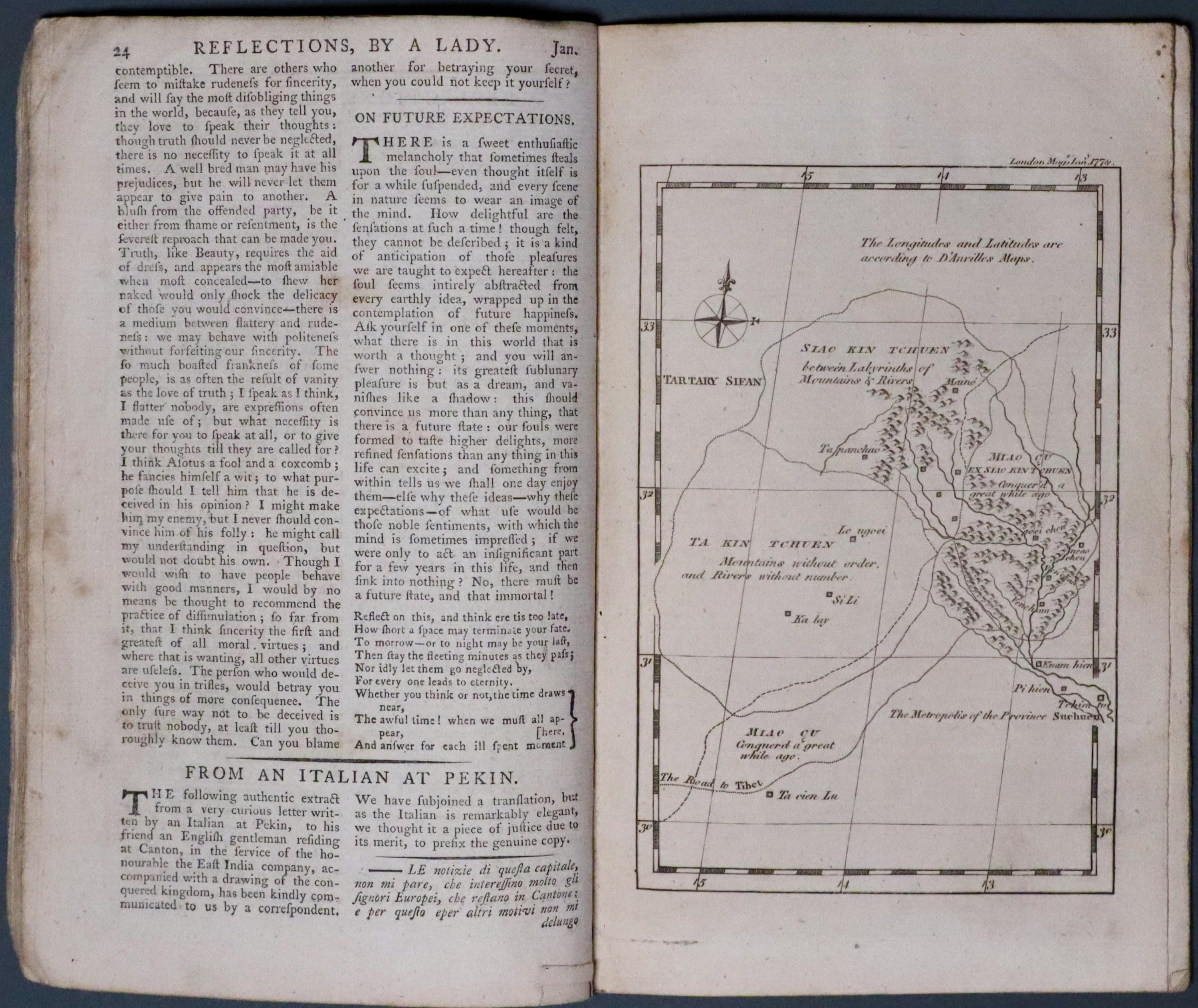
33716 Part of China, Thomas Kitchin, 1778. Price: 45.00
UNTITLED
A section from The London Magazine for 1778. Starting with the title page and running to page 48. Articles on The Glaciers in Switzerland, Censure and Praise, Female Virtue, Young Man of Fashion. At page 24 From an Italian at Pekin there is a full page map showing part of China with part of Sichuan. It indicates the road to Tibet. Compass pointer. 4 x 6 inches. Text continues with The Hypochondriack and The British Theatre.
Early 17th Century
-

Artois, Abraham Ortelius c.1600

33717 Artois, Abraham Ortelius, c.1600. Price: 160.00
ATREBATUM REGIONIS VERA DESCRIPTIO
A fine early engraved map of the region, embellished with two decorative cartouches. 19 x 15 inches, 490 x 380 mm. Later finely executed hand colouring. Latin text on verso. Good clean condition.
From: Theatrum Orbis TerraumLinked Text
American Revolution Map
-

-

Long Island, North America Thomas Kitchin 1778
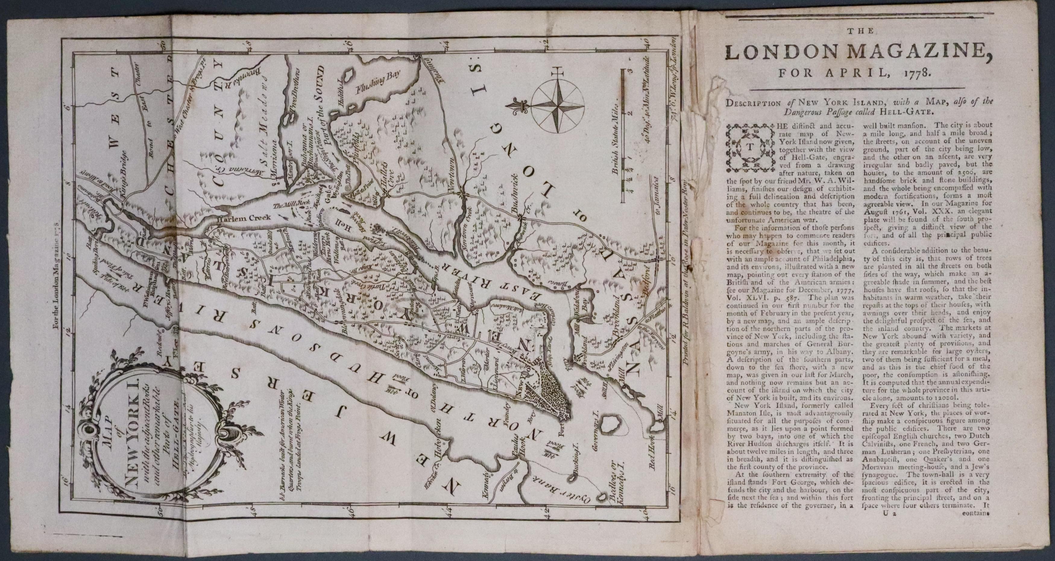

33718 Long Island, New York, Thomas Kitchin 1778. Price: 250.00
MAP OF NEW YORK I. WITH THE ADJACENT ROCKS AND OTHER REMARKABLE PARTS OF HELL-GATE
An interesting engraved map showing the area of Long Island and part of West Chester County. Also the notorious Hell-Gate where so many vessels perished owing to the unusual tides. Rococo title cartouche, compass pointer and scale. Still bound into the April 1778 part of The London Magazine running up to page 192 and the index page for April. Some slight damage where the map is bound effecting part of the imprint of the R. Baldwin with a very short tear passiing over the printed border into blank area. 9 1/2 x 7 1/4 inches. Uncoloured.
American Revolution Map
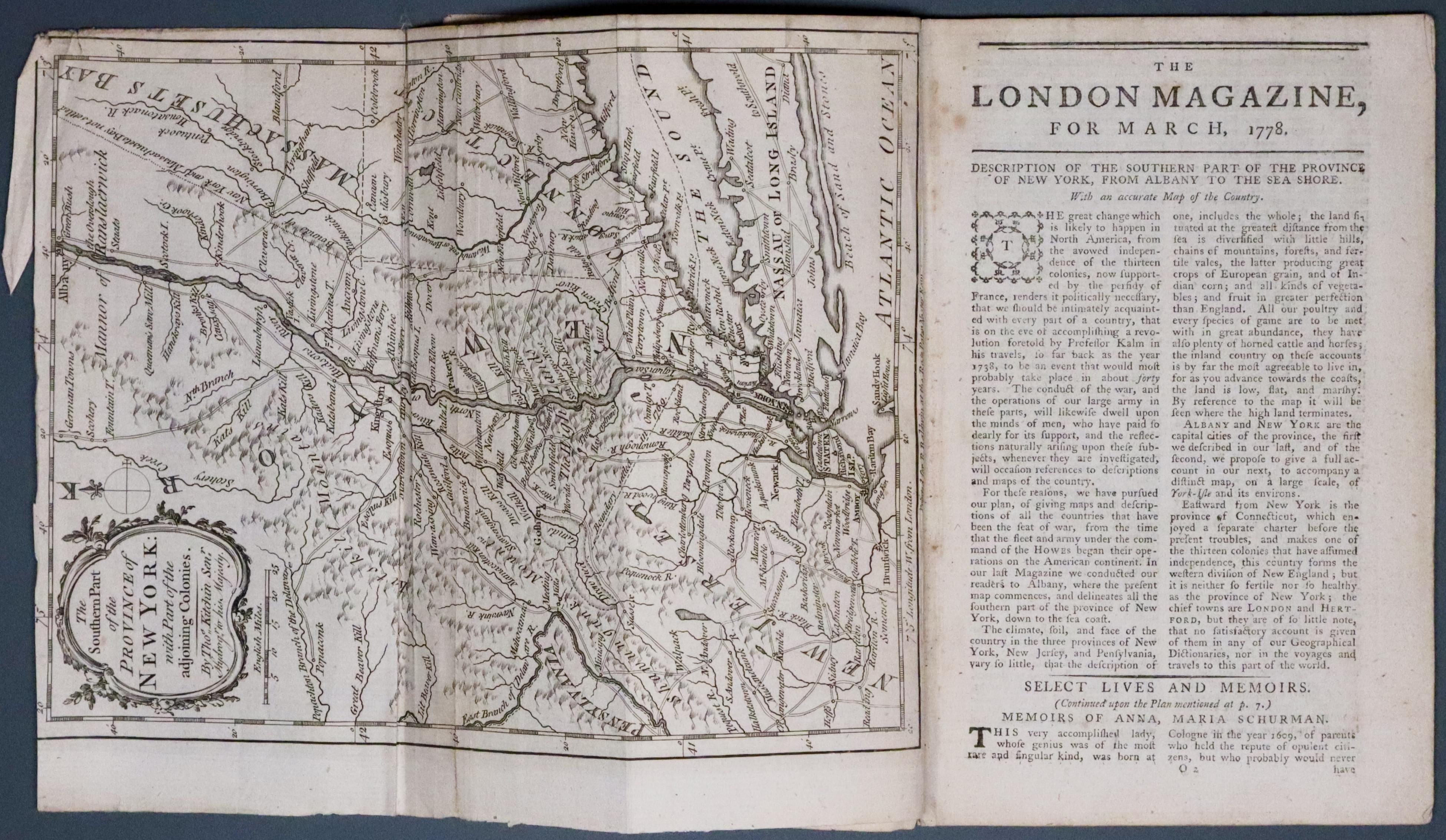
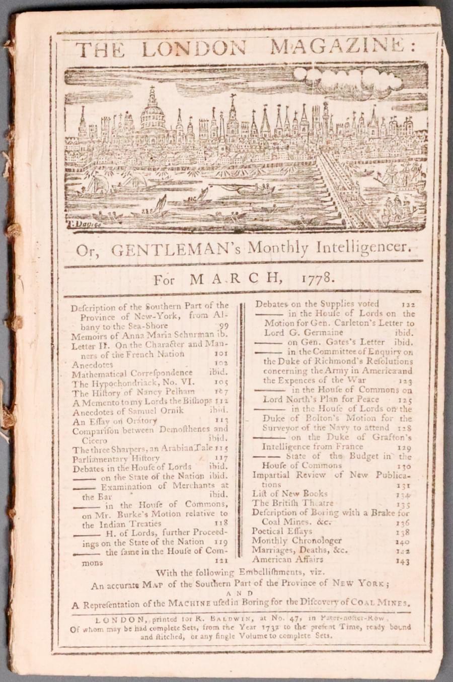
33719 Southern Part of New York, Thomas Kitchin, 1778. Price: 250.00
THE SOUTHERN PART OF THE PROVINCE OF NEW YORK WITH PART OF THE ADJOINING COLONIES
Part of The London Magazine for March 1778. Includes the index page with a view of London. The engraved map of Southern New York during the American Revolution by Thomas Kitchin. This extends from Albany to Long Island including parts of Massachusets Bay), Connecticut, and New Jersey. Two original fold creases. Part of the top blank margin is missing with a small portion of the top printed border. 7 x 9 1/4 inches. Uncoloured. The pages of the magazine from 99 to 144 including one page illustrating Boring Machine for the Discovery of Coal Mines.
16th Century
-

Moravia, Abraham Ortelius 1595

33720 Moravia, Abraham Ortelius, 1595. Price: 300.00
MORAVIAE QUAE OLIM MARCOMANNORUM SEDES COROGRAPHIA PAVLO FABRITIO MEDICO ET MATHEMATICO DESCRIPTA
A fine early engraved map of the country embellished with a handsome title cartouche. In the bottom right hand corner is the scale with a pair of divers and a coat of arms. 18 1/2 x 14 inches. Original centre fold. Uncoloured. Latin text on verso. Superb clean crisp condition having been taken straight from the atlas and not previously been sold as a single map.
From: Theatrum Orbis Terarum
17th Century
-

South Aegean Islands, Jan Jansson c.1650

33721 Southern Aegean Sea, Jan Jansson c.1650. Price: 220.00
ARCHIPELAGI MERIDIONALIS, SEU CYCLADUM INSULARUM ACCURATA DELINEATO. AUTORE LAURENBERGIO
A fascinating 17th century engraved if the southern islands in the Agean Sea. An attribution is given to the creator of the map is given in the title banner that stretches rifht across the to of the map, Professor Johannes Wilhelm Laurenberg who lived from 1590 to 1658. It appears in an atlas published by the Dutch cartographer Jan Jansson. Scattered amongst the islands are illustrations of sea monsters and sailing ships. Putti display the banner showing four scales. 21 1/4 x 18 1/4 inches. Uncoloured. Original centre fold. No top blank margin. Small area of expert restoration in the top left hand corner of the title banner. Small mark in the left hand blank marin, otherwise good clean condition.
Influential 18th Century Map
-

Canada, Guillame de L'Isle c.1726

25241 Canada, Guillaume de L'Lisle, c.1726. Price: Offers invited
CARTE DU CANADA OU DE LA NOUVELLE FRANCE
An interesting and in fact groundbreaking engraved map of Eastern Canada with the Great Lakes. It is one of the most important and influential map of the regions and remained so for many years. It was the first map to name Detrot two years after its founding. The title and three scale appear within a decorative cartouche flanked by images of North American Indians. The cartouche is dated 1703 but I have put a tentative date of 1726 on this map. This is because the map came from a de L’Isle atlas in which other maps were dated around this year and also as the title bears the words “Premier Geographe du Roy”. Guillaume received this title in 1718. 25 1/2 x 19 3/4 inches. Original centre fold. Outline hand colouring. Two small tears in the bottom blank margin just extending into the engraved area expertly repaired. Small top blank margin. Brown spot in the large blank area on the left, one in the sea area north of Newfoundland and another in the top border. A few other light spots in the blank margins. Lightly toned.
Late 16th Century
-

Hennenberg and Hessen, Abraham Ortelius 1595
-

Latin text for Saxiny and Thuringia, Abraham Ortelius 1595


33723 Hennenberg and Hessen, Abraham Ortelius, 1595. Price: 140.00
HENNERGERN SIS DITIONIS / HASSIAE DESCRIPTIO, JOAN; DE DRYAN; TORE
A foli sheet bearing two maps. To the left a map Henneberg which is shown at the centre. This map is embellished with a decorative title cartouche dated 1594. There is a separate cartouche showing the scale. To the right a map of Hessen including the towns of Kassel and Marburg. Title cartouche. Scale. Each map measures some 9 x 13 1/2 inches. Original centre fold. Superb clean crisp condition. Attractive and carefully executed later hand colouring. This map has come straight from the atlas and therefore not previously been sold as a single map.
Ftom: Theatrum Orbis Terrarum
19th Century Town Plan
-

Town plan of Berlin, Theadore Etting 1858

33725 Berlin, Theodore Ettling, 1858. Price: 39.00
BERLIN
BERLIN AND ENVIRONS FROM AUTHENTIC SURVEY A town plan of Berlin printed in sepia. Imprint below for the Weekly Dispatch Atlas and Drawn & Engraved by T. Ettling, 3 Red Lion Square, Holborn. 17 x 11 3/4 inches. Part of the imprint stamp of The Weekly Dispatch Atlas dated August 22nd 1858 in the top left hand blank margin. Small top blank margin. Light folding crease in centre. Small mark in the bottom blank margin otherwise good condition.
From: Weekly Dispatch Atlas
Late 18th Century
-

Part of Ukraine and Russia, Franz Johann Josph von Reilly 1789

24023 Part of Ukraine, Franz Johann Joseph von Reilly, 1789. Price: 70.00
DES RUSSISCHEN REICHES STATTHALTERSCHAFTEN WORONESCH, BELGOROD KIO O. KLEINRUSSLAND UND CHARKOW OD. D. RUSSISCHE UKRAINE NRO. 63
An engraved maps showing parts of Russia and Ukraine with Kharkiv. Rococo title cartouche. Two scales. Uncoloured. 10 3/4 x 8 inches. Wide blank margins. Fine clean crisp condition.
From: Schauplatz der funf Theile der Welt
Late 18th Century
-

Southern Russia with Moscow, Franz Johann Joseph von Reilly 1789

24024 Southern Russia with Moscow, Franz Johann Joseph von Reilly, 1789. Price: 120.00
Des Russischen Reiches Statthalterschaften Pleskow, Polozk, Mohilew, Twer, Moskau, Koluga, Wolodimer, Iaroslaw, Tula Smolensko und Nischgorod. Nro. 64.
An engraved map showing part of southern Russia centred on Moscow. Decorative title cartouche. Two scales. 12 x 8 1/4 inches. Some very pale early outline hand colouring. Large blank margins. Fine clean crisp condition.
From: Schauplatz der funf Theile der Welt
An engraved map showing part of southern Russia centred on Moscow. Decorative title cartouche. Two scales. 12 x 8 1/4 inches. Some very pale early outline hand colouring. Large blank margins. Fine clean crisp condition.
From: Schauplatz der funf Theile der Welt
RICHARD NICHOLSON
of CHESTER
Stoneydale
Pepper Street
Christleton
Chester
CH3 7AG
Telephone
01244 336004
International 44 1244 336004

I have been buying and selling antique maps since the early 1960's during which time I had a gallery in Watergate Street, Chester for 30 years. I am now able to offer through my websites a personal service to map and print collectors.

