More 19th Century Antique Maps of Lancashire
Richard Nicholson of Chester

Established in 1961
A World of Antique Maps and Prints

The maps on this page are guaranteed to be genuine early specimens published in or around the year stated
19th Century
-

Map of Lancashire by Cole & Roper c.1840

33115 Lancashire, Cole & Roper, c.1840. Price: 12.00
LANCASHIRE
A good detailed engraved map of the county divided into hundreds. The later version of Cole & Roper’s map published in 1810. 7 x 9 1/4 inches. Uncoloured. Original centre fold. Small amount of writing in ink on verso. TYhis does not show through to the front. Good condition.
19th Century Town Plan
-

Plan of Liverpool & Birkenhead, J. Bartholomew c.1880

33211 Liverpool and Birkenhead, George Philip & Son, c.1890. Price: 86.00
PHILLIP’S PLAN OF THE TOWN & PORT OF LIVERPOOL WITH BIRKENHEAD AND THE ADJOINING CHESHIRE COAST. COMPILED FROM ACTUAL SURVEY BY J. BARTHOLOMEW F.R.G.S.
A most interesting large detailed plan of Liverpool and Birkenhead. Extensive List of References in two panels listing 193 places of interest plus a list of Railway Stations. The map is divided into 24 sections and mounted on linen and folding. The front green titled board is detached. The map measures 28 1/4 x 24 inches. Other than the cover fault good undamaged condition.
19th Century - Decorative
-

Lancashire by Thomas Moule c.1837

33224 Lancashire, Thomas Moule, c.1837. Price: 50.00
LANCASHIRE
A decorative Victorian map of the county set within a patterned border with gothic architecture, vignette view of Nelson's Monument, Liverpool and seven coats of arms. 8 x 10 inches, 200 x 260 mm. Nicely hand coloured. Small right hand blank margin with parts of binding holes showing. All this could be hidden by a sunk mount. Otherwise a good specimen of this map on stout paper.
From: Moule’s English Counties
Liverpool - 19th Century Town Plan
-

Plan of Liverpool, James Newlands c.1860
-

Plan of Liverpool showing Birkenhead James Newlands c.1860
-

Plan of Liverpool showing Scotland Road area James Newlands c.1860
-

Plan of Liverpool showing city centre area James Newlands c.1860


33248 Liverpool, James Newlands, c.1860. Price: 360.00
PLAN OF THE BOROUGH OF LIVERPOOL FROM ACTUAL SURVEY. BY JAMES NEWLANDS, M.INST. C.E. BOROUGH ENGINEER
A uncommon large folding town plan of Liverpool with part of the Wirral coast showing Birkenhead and Bebington. Presented in an engraved decorative border with anchors at each corner. The map measures some 77 x 59 inches and is mounted with 40 sections on heavy canvas. The front and back when folded are titled LIVERPOOL. The out covers show some wear but generally the map is in nice clean undamaged condition.
19th Century - Decorative
-

Lancashire, Moule c.1850

33262 Lancashire, Thomas Moule c.1850. Price: 40.00
LANCASHIRE
A decorative Victorian map of the county set within a patterned border with gothic architecture, vignette view of Nelson's Monument, Liverpool and seven coats of arms. 8 x 10 inches, 200 x 260 mm. Uncoloured. Nice weight of paper. Small patch of masking tape on verso which appears to be repairing a very small tear which can hardly be seen on the front. Little browning on the top edge otherwise good condition.
Possible from Barclay’s Dictionary but could well be a few years older.
Early 19th Century - Fascinating

33655 Parish of Whalley and Clitheroe, James Bassire, 1801. Price: 150.00
HISTORY OF THE ORIGINAL PARISH OF WHALLEY AND HONOR
A most interesting engraved map published by J. Hatchard, Piccadilly, London 2nd November 1801. It extends from the Forest of Bowland in the north to Bury in the south. So many town shown such as Clitheroe with Pendle Hill, Accrington, Blackburn, Burnley, Haslingden, Oswaldtwistle, Bacup, Penwortham. Embellishments of small vignette views of country houses, parks and churches. The dedication in the blank top right area reads
To The Revd. Thomas Drake, D.D. Vicar of Rochdale, this <ap adapted to the HISTORY of the Original PARISH of WHALLEY and HONOR of CLITHEROE: & principally formed upon the Orthography of Charters is inscribes as an Acknoledgements of His man valuable Communications to this Work by His obliged & obedt. Servt. the Author
Scale and explanation. 29 1/4 x 23 1/4 inches. Uncoloured. Good heavy paper and in very clean condition. Fold creases which is normal with this map. Wide blank margins. Slit in one fold in the left hand blank margin area. About three small splits where the fold meets.
Not in Stock Often
-

Lancashire, Edward Langley 1818

33673 Lancashire, Edward Langley, 1818. Price: 82.00
LANGLEY’S NEW MAP OF LANCASHIRE
An engraved map of the county. In the top right hand corner is a vignette view of Liverpool. The title appears above the map. Beneath the map is the publishers imprint Printed and Published by Langley & Belch, No. 173 High Street, Borough, London, Febr. 1st, 1818. 6 3/4 x 10 inches. . Original outline and wash hand colouring. No tears or repairs. A good specimen.
From Langley’s New County Atlas of England and Wales
19th Century - Decorative
-

Lancashire, Thomas Moule c.1850

33679 Lancashire, Thomas Moule, c.1850. Price: 75.00
LANCASHIRE
A decorative Victorian map of the county set within a patterned border with gothic architecture, vignette view of Nelson's Monument, Liverpool and seven coats of arms. 8 x 10 inches, 200 x 260 mm. Hand coloured. Good condition. Presented in a 2 inch dark green sunk mount. Framed some years ago in a black and gold Hogarth moulding. This is still in good order.
From: Barclay's Dictionary
This map is only available by collection from Christleton
Detailed - Early Hand Colouring
-

Lancashire, Charles Smith 1808

33681 Lancashire, Charles Smith, 1808. Price: 115.00
A NEW MAP OF THE COUNTY PALATINE OF LANCASTER DIVIDED INTO HUNDREDS. LONDON
The second edition of this fine detailed map of the county dated 1808 with compass rose, explanation and list of hundreds. 17 3/4 x 19 3/4 inches. Original outline and wash hand colouring. Good condition. This map is presented in a 3 inch dark green mount and framed in a natural Arquati wood frame with two inset green lines. Framed some years ago but still in nice condition.
From: Smith’s New English Atlas
This map is only available by collection from Christleton
Early 19th Century
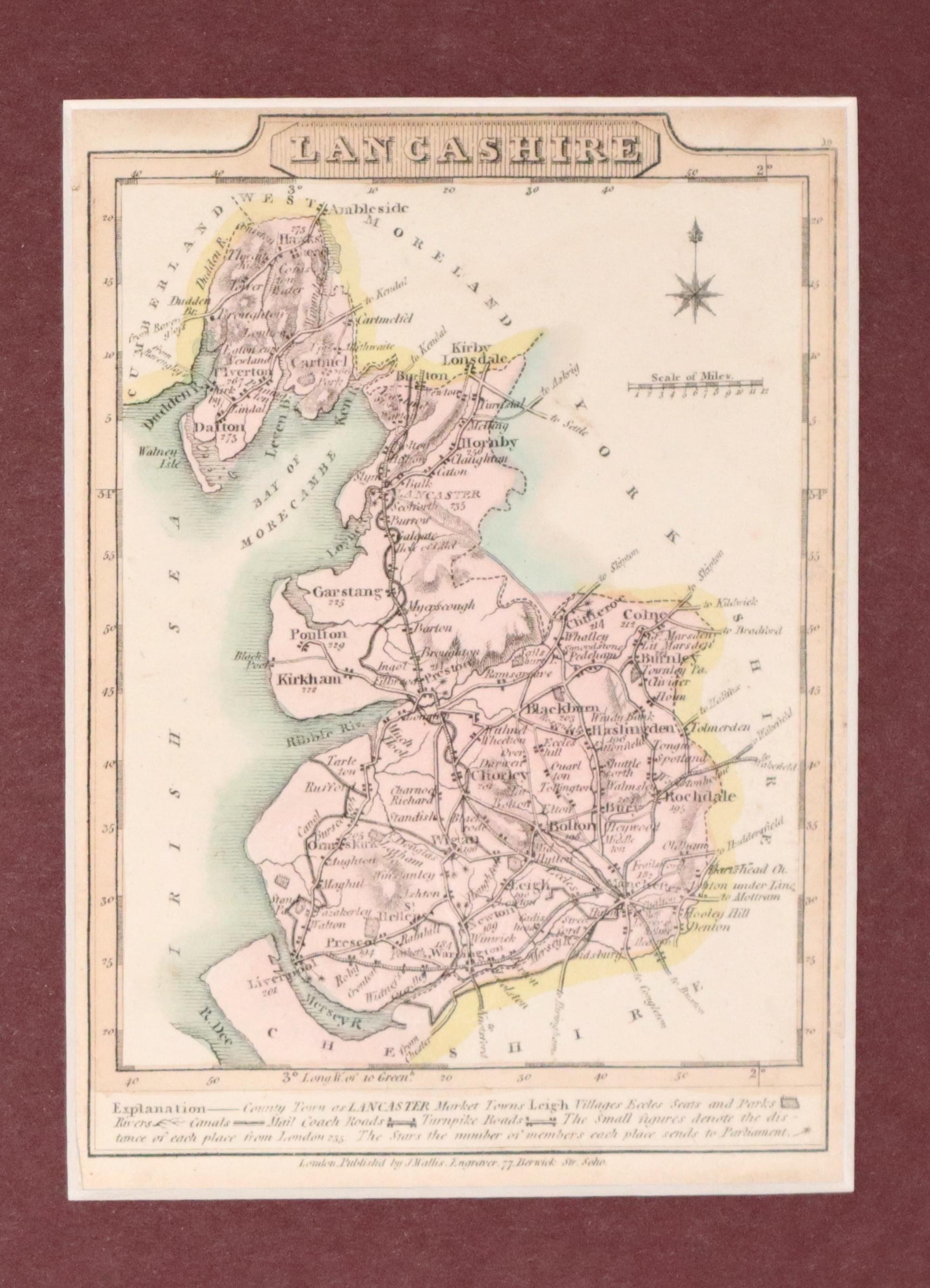
33684 Lancashire, J. Wallis, 1819. Price: 27.00
LANCASHIRE
A small engraved county map with short description beneath. 3 x 4 inches. Original outline and wash colouring. Good condition. Presented in a 2 1/2 inch maroon coloured sunk mount.
Shows Railways - Early Hand Colourng
-

Lancashire, John & Charles Walker c.1852

33692 Lancashire, John & Charles Walker, c.1852. Price: 55.00
LANCASHIRE
A good detailed engraved map of the county including the railways. Title panel with the names of J. & C. Walker beneath. Scale and explanation. List of hundreds. Original outline and wash hand colouring. Imprint of Longman, Rees, Orme, Browne & Co. Paternoster Row beneath. 12 1/2 x 15 1/5 inches. Original centre fold. Good condition. This map is presented in a 2 1/2 in ivory tint sunk mount with gold line and framed in a black and gold Hogarth moulding some years go. The frame is still in good condition.
From: The British Atlas
Only available to customers who can collect from Christleton
RICHARD NICHOLSON
of CHESTER
Stoneydale
Pepper Street
Christleton
Chester
CH3 7AG
Telephone
01244 336004
International 44 1244 336004

I have been buying and selling antique maps since the early 1960's during which time I had a gallery in Watergate Street, Chester for 30 years. I am now able to offer through my websites a personal service to map and print collectors.

