Antique Maps of
Naples - Piedmont - Roman Empire
Richard Nicholson of Chester

Established in 1961
A World of Antique Maps and Prints

The maps on this page are guaranteed to be genuine early specimens published in or around the year stated
NAPLES
19th Century - Genealogical
-

Naples and Sicily, C. V. Lavoisne, 1830

27593 Naples and Sicily, C. V. Lavoisne, 1830. Price: 20.00
GENEALOGICAL, HISTORICAL, AND CHRONOLOGICAL MAP OF HOUSES OF THE KINGDOMS OF NAPLES AND SICILY, FROM THE FOUNDATION OF THE MONARCHY, 1130, TO THE YEAR 1828
A fascinating table which would make a most interesting wall decoration. 20 1/2 x 16 1/2. Original wash hand colouring. Good condition.
From: Lavoisne’s Complete Genealogical, Historical, Chronological, and Geographical Atlas. The fourth edition printed and published by J. Barfield in London
18th Century - Sea Chart
-

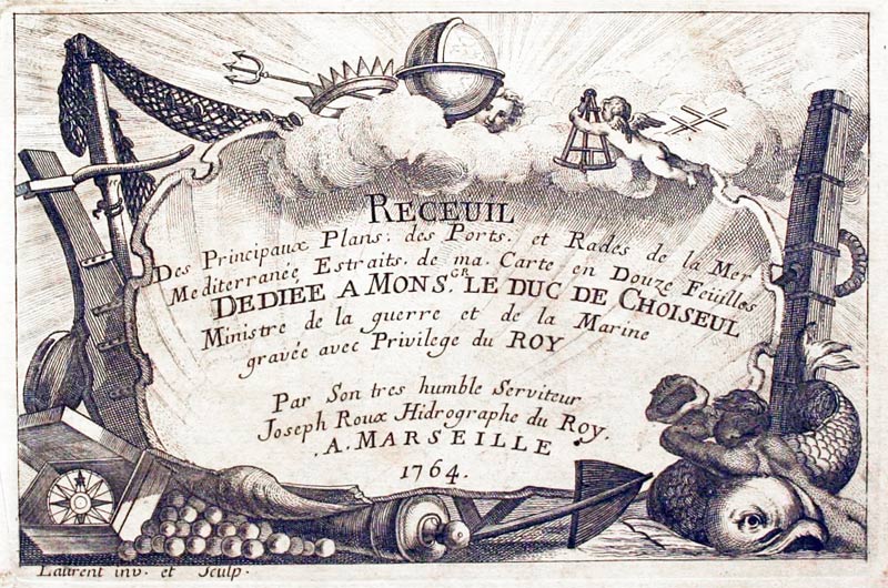
Port Talon, Naples, Joseph Roux, 1764

27942 Port Talon, Naples, Joseph Roux, 1764. Price: 45.00
PLAN DU PORT ET MOUILLAGE DE NAPLES DE ROMANIE
A small engraved chart showing the port with depth soundings and anchorage points. Scale and compass pointer. 7 1/2 x 5 inches. Uncoloured. Good condition.
Plate 81 From: Receuil Des Principaux Plans; des Ports, et Rades de la Mer Mediterranée, Estraits, de ma. Carte Douze Feüilles.... Marselle 1764
18th Century - Sea Chart
-

Pozzuoli Italy, Jacques Nicholas Bellin, 1764

29590 Pozzuoli, Jacques Nicholas Bellin, 1764. Price: 62.00
PLAN DE BAYES ET POUSSOLE
An engraved chart of the Italian coast with the town of Pozzouli with the bay from Cape Mizene to Cape Coroille. Uncoloured rococo cartouche. 6 3/4 x 8 1/4 inches. Good clean condition.
From: Le Petit Atlas Maritime. Volume 4 Map number 85
18th Century
-

Kingdom of Naples, G. Robert de Vaugondy, 1762

30468 Kingdom of Naples, G. Robert de Vaugondy, 1762. Price: 25.00
ROYAUME DE NAPLES PAR LE S. ROBERT DE VAUGONDY AVEC PRIVILEGE 1762
An engraved map of the Kingdom of Naples with an inset map of the island of Sicily. Decorative title cartouche. 11 x 98 1/4 inches. Hand coloured. Some browning and scattered foxing.
19th Century
-

Naples and Sicily, James S.Virtue, c.1860

31556 Naples and Sicily, James S. Virtue, c.1860. Price: 14.00
NAPLES AND SICILY
A tinted lithograph map set within a decorative border. Original centre fold. 9 1/2 x 12 1/2 inches. Good clean condition.
PIEDMONT
16th Century
-

Piedmont Girolomo Ruscelli 1599

32014 Piedmond, Girolomo Ruscelli, 1599. Price: 150.00
TAVOLA NUOVA DI PIEMONTE
Based upon a map by Giacomo Gastaldi. An interesting early engraved map of the region of Piedmont in northern Italy. 9 1/2 x 7 inches. Uncoloured. Centre fold as issued. Italian text on verso. Small tear on the edge of the bottom blank margin othewise g ood clean condition with wide blank margins. Straight from the atlas so not not offered previously for sale as a single map.
From the sixth edition of Ruscelli's translation of Ptolemy's Geografia edited and extended by Giuseppe Rosaccio published by the Heirs of Melchior Sessa in 1599
ROMAN EMPIRE
18th Century - Early Hand Colouring
-

Ancient Rome and Regions, Guillaume de L'Isle, c.1731

25252 Ancient Rome and Regions, Guillaume de L'Isle, c.1731. Price: 135.00
REGIONUM ITALIAE MEDIARUM TABULA GEPGRAPHICA
An interesting map engraved by Derosier by the celebrated French cartographer Guillaume de L’Isle of the regions around ancient Rome. Inset plan of early Rome titled “Urbs Septicollis” showing the seven hills. 24 1/2 x 18 inches. Original outline hand colouring. Very small slit the the bottom of the centre fold otherwise good condition.
19th Century - Early Hand Colouring
-

Roman Empire, C. V. Lavoisne, 1830

27529 Roman Empire, C. V. Lavoisne, 1830. Price: 40.00
GEOGRAPHICAL AND HISTORICAL MAP OF THE ROMAN EMPIRE
An engraved map of the Roman Empire bordered on three sides by panels of text. The text panels cover the Supreme and Subordinate Magistrates, Progressive Incease of the Roman Empire, Campaign of Hannibal and the Apocalyptic Kings and Horns. Oval title panel reads Map of the Roman Empire Intended for the Elicidation of Lasoisne’s Historical Atlas By C. Gros. Revised 1828. The map and text together measure 20 1/2 x 16 1/2 inches. Original wash hand colouring. Good condition.
From: Lavoisne’s Complete Genealogical, Historical, Chronological, and Geographical Atlas
19th Century - Early Hand Colouring
-

The Roman Empire, Conrad Malte-Brun 1837

32310 The Roman Empire, Conrad Malte-Brun, 1812. Price: 36.00
EMPIRE ROMAIN SOUS CONSTANTIN ET SOUS TRAJAN
An engraved map. The title is shown on an uncoloured flag. Uncoloured vignette view in the lower right hand corner of a square with pillar. 11 x 8 inches. Original outline hand colouring. Manuscript ‘No 16’ in the tight hand blank margin. Three small brown marks, one on the map and the others in the blank margin. Otherwise good condition.
From: Atlas Complet du Precis de la Geographie Universelle...
Roman Empire by a German Mapmaker
-

Roman Empire by Dr. Henry Kiepert c.1902

33452 Roman Empire, Dr. Henry Kiepert, c.1902. Price: 25.00
IMPERIUM ROMANUM
A lithograph map of the Roman Empire in ancient times. Inset map. 17 x 13 inches inches. Original centre fold. Good condition.
From: Atlas Antiquus published in Berlin
Ancient Rome
-

nient Rome by Dr. Henry Kiepert c.1902

33449 Ancient Rome Dr. Henry Kiepert, c.1902. Price: 25.00
ROMA URS
A lithograph map showing in three maps and plans Rome and the surrounding area in ancient times. Inset map. 13 1/4 x 16 3/4 inches. Original centre fold. Good condition.
From: Atlas Antiquus published in Berlin


RICHARD NICHOLSON
of CHESTER
Stoneydale
Pepper Street
Christleton
Chester
CH3 7AG
Telephone
01244 336004
International 44 1244 336004

I have been buying and selling antique maps since the early 1960's during which time I had a gallery in Watergate Street, Chester for 30 years. I am now able to offer through my websites a personal service to map and print collectors.

