ANTIQUE MAPS of
BOULOGNE - BOURGOGNE, BRETAGNE
BEARN and BRESSE
Richard Nicholson of Chester

A World of Antique Maps and Prints
Established in 1961
All the Maps on this page are guaranteed to be genuine early specimens
published in or around the year stated
BOULOGNE
17th Century
-

Boulogne, Mercator / Jansson 1635

32021 Boulogne, Mercator / Jansson 1635. Price: 45.00
BOLONIA ET GUINES COM
A small engraved early map of Bologne and Guines in the Pay-de-Calais department of northern France. Embellished with a cartouche displaying the title and scale. 7 x 5 3/4 inches. Uncoloured. Latin text on verso. Good condition.
From: Atlas Minor
BOURGOGNE
The région of Bourgogne is both larger than the old Duchy of Burgundy and smaller than the area ruled by the Dukes of Burgundy. It is made up of the following old provinces: Burgundy: Côte-d'Or, Saône-et-Loire, and southern half of Yonne. This corresponds to the old duchy of Burgundy (later called "province of Burgundy"). However, the old county of Burgundy (later called "province of Franche-Comté") is not included inside the Bourgogne région, but it makes up the Franche-Comté région. Also, a small part of the duchy of Burgundy (province of Burgundy) is now inside the Champagne-Ardenne région. Nivernais: Nièvre département. The northern half of Yonne is a territory that was not part of Burgundy (at least not since the 11th century), and was a frontier between Champagne, Île-de-France, and Orléanais, depending from each of these provinces at different times in history.
Early 19th Century - Original Hand Colouring
-

Berri, Bourgogne, Lyonnais, Robert de Vaugondy 1812

29717 Berri, Bourgogne, Lyonnais…. Robert de Vaugondy / Charles Francois Delamarche, 1812. Price: 20.00
BERRI, NIVERNOIS, BOURBONOIS LYONOIS, BOURGOGNE, BRESSE ET FRANCHE-COMTE. CORRIGES PAR C. F. DELAMARCHE SON SUCCESSEUR
A good engraved map of the region with a shaped title panel. List of departments and two scales. 10 1/2 x 9 1/2 inches. Original outline hand colouring. Good condition. Wide blank margins.
Early 19th Century - Original Hand Colouring
-

Berry, Bournonnois,Nivernois, G. Robert de Vaugondy, 1749

29736 Berry, Bournonnois and Nivernois, G. Robert de Vaugondy, 1749. Price: 23.00
GOUVERNEMENT GENERAUS DU BERRY, DU BOURBONNOIS, ET DU NIVERNOIS....1748
An engraved map of the region with title panel dated 1748. 6 1/2 x 6 1/4 inches. Original outline hand colouring. Good condition.
BRETAGNE
18th Century Sea Chart - Early Hand Colouring
-

Bretagne, J. N. Bellin 1764

11152 Bretagne Coast, J. N. Bellin, 1764. Price: 49.00
PARTIE DE LA COSTE DE BRETAGNE DEPUIS LE CAP DE FREHEL JUSQU'A ST. QUAY
Chart of part of the Brittany coast. Uncoloured rococo cartouche. 14 x 9 inches. Original blue outline and wash colouring. Good condition.
From: Le Petit Atlas Maritime
18th Century Plan and Chart - Early Hand Colouring
-

Nantes, J. N. Bellin 1764

23658 Nantes, Jacques Nicolas Bellin, 1764. Price: 56.00
PLAN DE LA VILLE DE NANTES. Engraved TOWN PLAN OF NANTES
An engraved map with an uncoloured rococo cartouche displaying the title, scale and key to 10 places of interest. 12 3/4 x 8 1/2 inches. Original blue outline and wash colouring. Good condition.
From: Le Petit Atlas Maritime
Early 19th Century - Original Hand Colouring
-

Normandy and Britanny, Vaugondy 1812

29719 Normany, Britanny and Touraine, Robert de Vaugondy / Charles Francois Delamarche, 1812. Price: 26.00
FLANDRE FRANCOISE, PICARDIE ET ARTOIS, ISLE DE FRANCE, ORLEANOIS, CHAMPAGNE, LORRAINE ET ALSACE. PAR ROBERT DE VAUGONDY GEOGRAPHE CORRIGES PAR C. F. DELAMARCHE SON SUCCESSEUR
A good engraved map of the region with a shaped title panel dated 1806. List of departments and two scales. 11 1/4 x 9 1/2 inches. Original outline hand colouring. Good condition. Wide blank margins.
BURGUNDY
17th Century
-

Burgundy, Nicolaes Visscher, c.1700

11132 Burgundy, Nicolaes Visscher, c.1700. Price: 105.00
COMITATUS BURGUNDIAE....
An engraved map extending as far south as Geneva. Decorative cartouche with coat of arms and figures displaying the title and scales. Royal arms of George III of England. 18 x 22 inches, 460 x 560 mm. Uncoloured. Small circular brown stain in printed border, otherwise good.
17th Century - Early Hand Colouring
-

Burgundy, Jan Jansson 1647

11133 Burgundy, Jan Jansson, c.1647. Price: 130.00
COMITATUS BURGUNDIAE
An engraved map orientated with east at the top. Decorative title cartouche with three figures. Scale cartouche. Coat of arms. Latin text on verso. 21 x 16 1/2 inches. Original hand colouring. Marginal tear. Some light creasing near centre fold.
17th Century
-
Burgundy, Nicolaes Visscher, c.1700
21680 Burgundy Nicolaes Visscher, c.1700. Price: 135.00
COMITATUS BURGUNDIAE….
An engraved map extending as far south as Geneva/ Decorative cartouche with coat of arms and figures displaying the title and scales. Royal arms of George III of England. 18 x 22 inches, 460 x 560 mm. Original outline hand colouring. Blank margins browned.
BEARN
17th Century - Original Hand Colouring
-

Bearn, Jan Jansson 1647

5545 Bearn, Jan Jansson 1647. Price: 115.00
LE PAIS DE BEARN.....
A good 17th century map of Bearn embellished with decorative title and scale cartouches. 19 x 15 inches, 500 x 380 mm. Dutch text on verso. Hand coloured. Good condition.
From: Nieuwen Atlas
17th Century - Early Hand Colouring
-

Bearn, J. Jansson, c.1647

10961 Bearn, Jan Jansson, c.1647. Price: 135.00
LE PAIS DE BEARN Avec Privilege du Roy
A fine engraved map of the region Bearn. Decorative title cartouche. Scale cartouche with two figures. Latin text on verso. 19 x 15 inches, 500 x 375 mm. Full original hand colouring. Good condition.
Early 19th Century - Original Hand Colouring
-

Guyenne, Gascogne and Bearn, Robert de Vaugondy / Charles Francois Delamarche, 1812

29724 Guyenne, Gascogne and Bearn, Robert de Vaugondy / Charles Francois Delamarche, 1812. Price: 20.00
GUIENNE ET GASCOGNE, BASSE NAVARRE ET BEARN. PAR ROBERT DE VAUGONDY GEOGRAPHE. CORRIGES PAR C. F. DELAMARCHE SON SUCCESSEUR
A good engraved map of the region with a shaped title panel. List of departments and two scales. 10 1/4 x 9 1/2 inches. Original outline hand colouring. Good condition. Wide blank margins.
BRESSE
18th Century
-

Bresse, Henri du Sauzet, 1734
-

Verso of map Bresse, Henri du Sauzet, 1734


30466 Bresse, Henri du Sauzet, 1734. Price: 29.00
BRESSE
An engraved map of the province. Decorative title cartouche. Two scales. 10 x 7 1/4 inches. Hand coloured. I have have recently taken this map out of its frame which it appears to have been in for a number of years. I do not wish to remove it from the mount. From the second photo you willsee it is attached on verso with brown paper tape. The wrinkling is far more evident on the verso and hardly shows on the map front. Paper is toned. No tears or repairs.
BORDEAUX
Late 17th Century
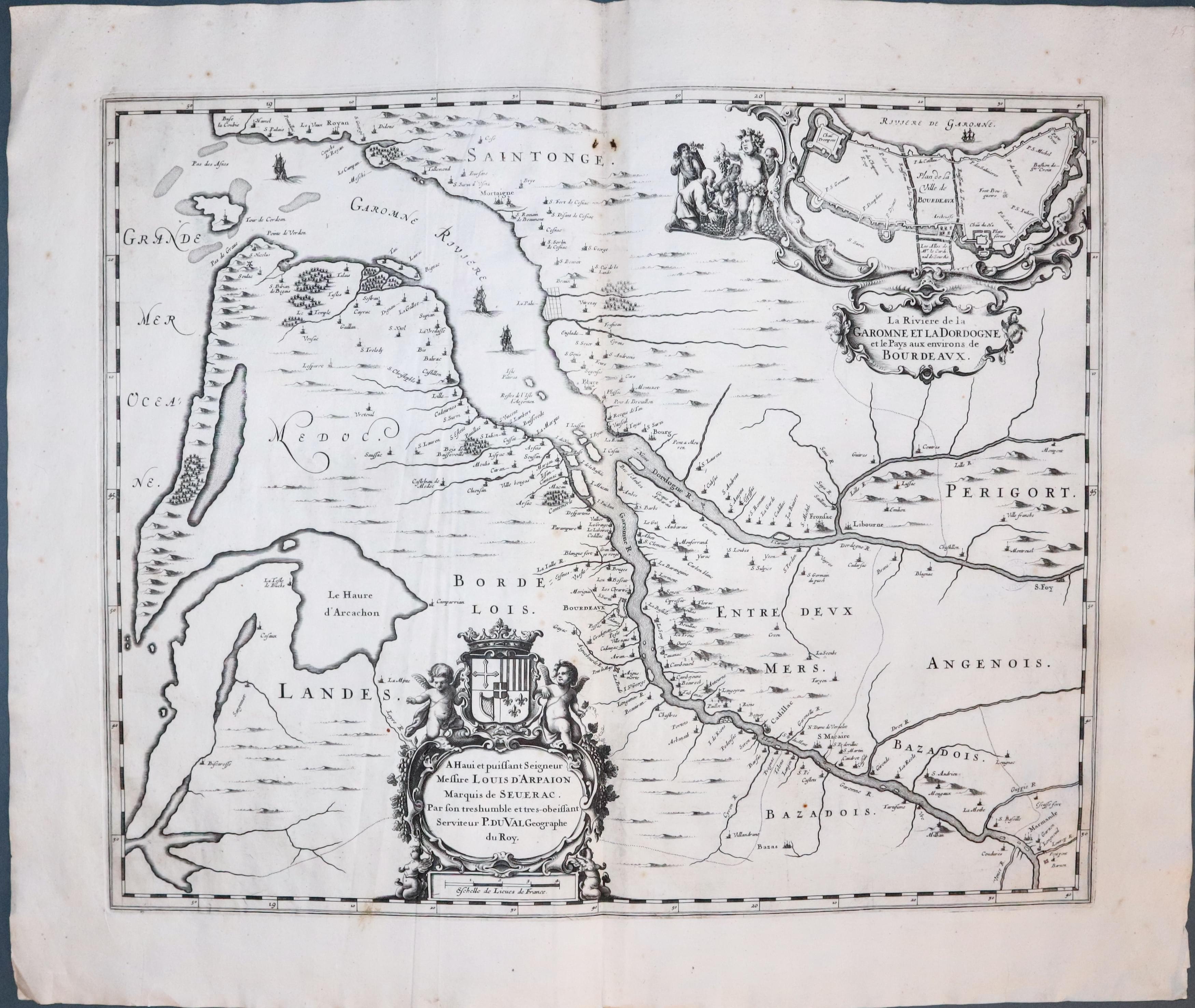
Estuary & Environs of Bordeaux, Pierre du Val, c.1680. Price: 125.00
La Riviere de la Garomne et la Dordogne et le Pays aux Environs de Bordeaux
An impressive looking engraved map of the Gironde estuary where the Dorgogne River and Garonne River meet. The map is embellished with two decorative cartouches. The title cartouche has an inset plan of Bordeaux and putti. The dedication cartouche is surmounted buy a coat of arms and two putti with the scale beneath. 20 3/4 x 17 inches. Uncoloured. Original centrefold. Large blank margins. There is some light creasing mainly to the left hand side of the map. Good clean condition.

RICHARD NICHOLSON
of CHESTER
Stoneydale
Pepper Street
Christleton
Chester
CH3 7AG
Telephone
01244 336004
International 44 1244 336004

I have been buying and selling antique maps since the early 1960's during which time I had a gallery in Watergate Street, Chester for 30 years. I am now able to offer through my websites a personal service to map and print collectors.
