Antique Maps of Australia
Richard Nicholson of Chester

Established in 1961
A World of Antique Maps and Prints

The maps on this page are guaranteed to be genuine early specimens published in or around the year stated
AUSTRALIA
19th Century
-

Australia and New Zealand, Archibald Fullarton, c.1872

24415 Australia and New Zealand, Archibald Fullarton, c.1872. Price: 95.00
AUSTRALIA AND NEW ZEALAND ACCORDING TO ARROWSMITH AND MITCHELL. DRAWN BY AUGUSTUS PETERMANN F.R.G.S.
A colour lithograph map showing Australia and New Zealand with three inset maps of Victoria and regions, Goldfields of Mount Alexander and part of New South Wales. 20 x 16 1/4 inches. A little light spotting in the blank margins otherwise good condition.
From: The Royal Illustrated Atlas published by Archibald Fullarton and Company
19th Century - Early Hand Colouring
-

Western and South Australia, Edward Weller, 1858

27793 Western and South Australia, Edward Weller, 1858. Price: 40.00
WESTERN AUSTRALIA / SOUTH AUSTRALIA
A sheet with two lithograph maps. 16 3/4 x 12 inches. Original hand colouring. Weekly Dispatch Atlas impression stamp in the bottom left hand corner dated 1858. Good condition.
From: The Weekly Dispatch Atlas
19th Century - Early Hand Colouring
-

Australia, George Frederick Cruchley, 1848

31524 Australia, George Frederick Cruchley, 1848. Price: 96.00
AUSTRALASIA, NEW ZEALAND, EAST INDIA ISLANDS &C. &C.
A clearly engraved map bearing the imprint April 1st 1842. Publishers rococo cartouche inscribed Cruchley’s Improved Atlas, for Schools & Families. 17 1/4 x 13 3/4 inches. Original outline and wash hand colouring. Small split at the bottom of the centre fold and a little browning in the centre fold. Otherwise good condition.
From: Cruchley’s General Atlas for the use of Schools and Private Tuition
Important Map - 19th Century
-

Australia, James Wyld c.1850

33215 South Australia, James Wild, c.1850. Price: 500.00
MAP OF SOUTH AUSTRALIA, NEW SOUTH WALES, VAN DIEMANS LAND AND SETTLES PARTS OF AUSTRALIA RESPECTFULLY DEDICATED TO MAJOR SIR T. L. MITCHELL Kt. D.C.L. F.G.S. &c. SURVEYOR GENERAL OF NEW SOUTH WALES.
A fascinating engraved map early map of Australia showing the settled parts along with the discoveries from expeditions into the interior. Along with the main map are insets maps of Western Australia, Victoria, Van Diemans Land and Sydney. Published by James Wyld, Charing Cross East, Geographer To Her Majesty. London. Original outline and wash hand colouring. Dissected onto 24 sheets and mounted on linen. with thin purple coloured end boards. An advertisement listing maps by James Wyld appears on the verso of one section. 37 3/4 x 23 3/4 inches. Good condition.
19th Century
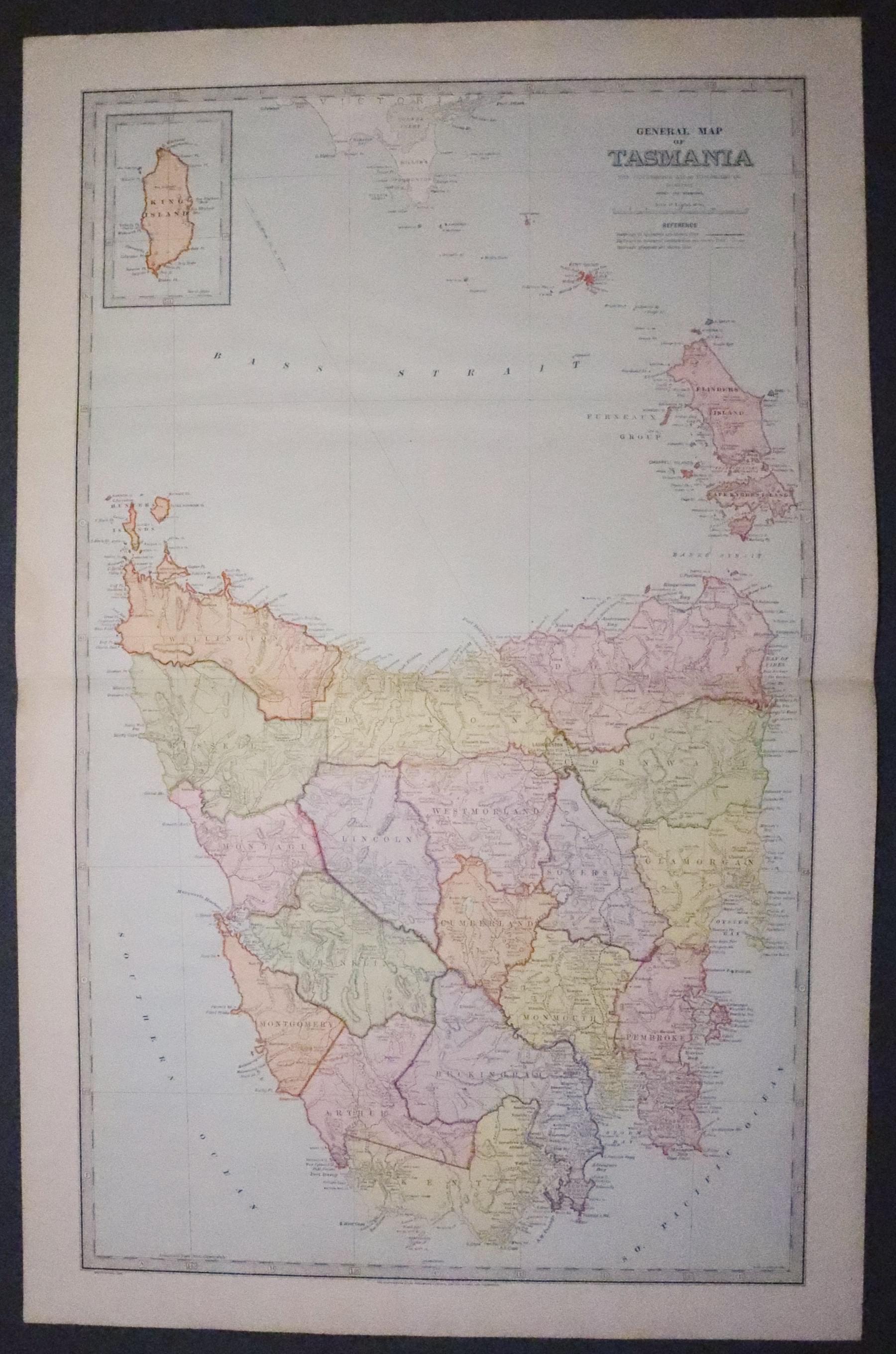
33294 Tasmania, Picturesque Atlas,c.1880. Price: 25.00
GENERAL MAP OF TASMANIA
A good large coloured lithograph map of the island from The Picturesque Atlas. Small inset of King Island. Long list of towns and places on Tasmania with their map reference on verso with small view. 23 3/4 x 14 1/2 inches. Good clean condition.
From: The Picturesque Atlas

PACIFIC
19th Century - Early Hand Colouring
-

Pacific Ocean, John Dower, c.1847

23114 Pacific Ocean, John Dower, c.1847. Price: 28.00
PACIFIC OCEAN
An engraved map with original outline hand colouring. Small uncoloured illustration in the bottom right hand corner showing the heights of various mountains in the region. 10 1/4 x 8 1/4 inches. Good condition.
From: A School Atlas of Modern Geography
19th Century - Early Hand Colouring
-

New Zealand and South Pacific, Conrad Malte-Brun, 1812

24953 New Zealand and South Pacific, Conrad Malte-Brun, 1812. Price: 96.00
OCEANIQUE ORIENT
An engraved map showing part of the east coast of Australia, New Zealand and the south Pacific Islands. The title is shown on the sail of a boat within a scene. 11 1/2 x 8 1/2 inches. Original outline hand colouring. Good condition.
From: Atlas Complet...
19th Century - Early Hand Colouring
-

Pacific Ocean, James Wyld, 1839

28003 Pacific Ocean, James Wyld, 1839. Price: 50.00
PACIFIC OCEAN
An engraved map embellished with a pictorial symbolic title cartouche. Inset map of Tahiti. 9 x 7 1/4 inches. Original outline hand colouring. Good clean condition.
From: An Atlas of Maps of Different Parts of the World; designed to show the stations of the Protestant Missionaries By James Wyld, Geographer to the Queen. London: James Wyld, Charing Cross East. MDCCCXXXIX
18th Century
-

Caroline Islands in the Pacific, J. N. Bellin c.1764

32712 Caroline Islands, Jacques Nicolas Bellin, c.1764. Price: 40.00
NOUVELLE CARTE DES ISLES CAROLINES. NIEU KAART DER CAROLYNSCHE EYLANDEN
An engraved map of the Caroline Islands, a widely scattered archipelago of tiny islands in the western Pacific Ocean. Situated north of New Guinea and east of the Philippines. Decorative rococo title cartouche. The map has been cut close around and mounted on a larger sheet many years ago. Traces of a centre fold. 15 1/4 x 7 3/4 inches. Uncoloured. A little light soiling to the backing but otherwise good condition.
Islands in the Pacific
-

Cocos Islands, Tonga c.1780

49123 Cocos & Traitors Islands, Tonga. Middleton, c.1780. Price: 35.00
A PERSPECTIVE VIEW OF COCOS AND TRAITOR'S ISLANDS DISCOVERED IN THE VOYAGES TO THE SOUTH SEAS
An interesting copper engraved view showing natives from the islands of Tafahi and Niuatoputapu, being part of Tonga coming out in their small boats to attack a sailing ship anchored in the bay. 10 x 6 1/4 inches. Hand coloured. A few small light foxing spots otherwise good condition.
Engraved for Middleton's Complete System of Geography


RICHARD NICHOLSON
of CHESTER
Stoneydale
Pepper Street
Christleton
Chester
CH3 7AG
Telephone
01244 336004
International 44 1244 336004

I have been buying and selling antique maps since the early 1960's during which time I had a gallery in Watergate Street, Chester for 30 years. I am now able to offer through my websites a personal service to map and print collectors.

