Antique Maps of China
Richard Nicholson of Chester
A World of Antique Maps and Prints

Established in 1961
All the Maps on this page are guaranteed to be genuine early specimens
published in or around the year stated
17th Century
-

Xansi, Vincenzo Coronelli, c.1696

28719 Xansi, Vincenzo Coronelli, c.1696. Price: 320.00
XANSI, E XENSIS, PROVINCIE DELLA CHINE...
An engraved map of the region. A decorative title cartouche with coat of arms. Decorative scale cartouche and a third foliage cartouche with note. 23 1/2 x 17 3/4 inches, 600 x 450 mm. Uncoloured. Slit about 1/8 inch wide near centre fold with some loss in the desert area. Otherwise fine clean condition with good margins.
This map is one of Coronelli’s six maps showing the thirteen provinces of China, modelled on the earlier map by Joan Blaeu and the Jesuit Martino Martini.
From: Coronelli's Corso Geografico Universalle
17th Century
-

Iunan, Queicheu and Quangsi, Vincenzo Coronelli, c.1696

28720 Iunan, Queicheu and Quangsi, Vincenzo Coronelli, c.1696. Price: 380.00
IUNAN, QUEICHEU, E QUANGSI
An engraved map of the three provinces. Iunan (Yunnan), Queicheu (Guizhou) and Quangsi (Guangsi).Title within a large banner cartouche. Decorative scale cartouche. 23 1/2 x 17 3/4 inches, 600 x 450 mm. Uncoloured. Fine clean condition with good margins.
This map is one of Coronelli’s six maps showing the thirteen provinces of China, modelled on the earlier map by Joan Blaeu and the Jesuit Martino Martini.
From: Coronelli's Corso Geografico Universalle
17th Century
-

Chekiang and Kiangski, Vincenzo Coronelli, c.1696

30141 Chekiang and Kiangski, Vincenzo Coronelli, c.1696. Price: 380.00
CHEKIANG, E KIANSI, PROVINCIE DELLA CHINE...
An engraved map of this coastal region. A large decorative title cartouche with coat of arms. Decorative scale cartouche. 23 1/2 x 17 3/4 inches, 600 x 450 mm. Uncoloured. Fine clean condition with good margins.
This map is one of Coronelli’s six maps showing the thirteen provinces of China, modelled on the earlier map by Joan Blaeu and the Jesuit Martino Martini.
From: Coronelli's Corso Geografico Universalle
19th Century
-

China, George Frederick Cruchley, 1848

31523 China, George Frederick Cruchley, 1848. Price: 75.00
CHINA
A clearly engraved map of the country bearing the imprint February 1st 1842. Publishers rococo cartouche inscribed Cruchley’s Improved Atlas, for Schools & Families. 17 1/4 x 13 3/4 inches. Original outline and wash hand colouring. Small slit at the bottom of the centre fold. Some browning in the centre fold, otherwise good condition.
From: Cruchley’s General Atlas for the use of Schools and Private Tuition
19th Century
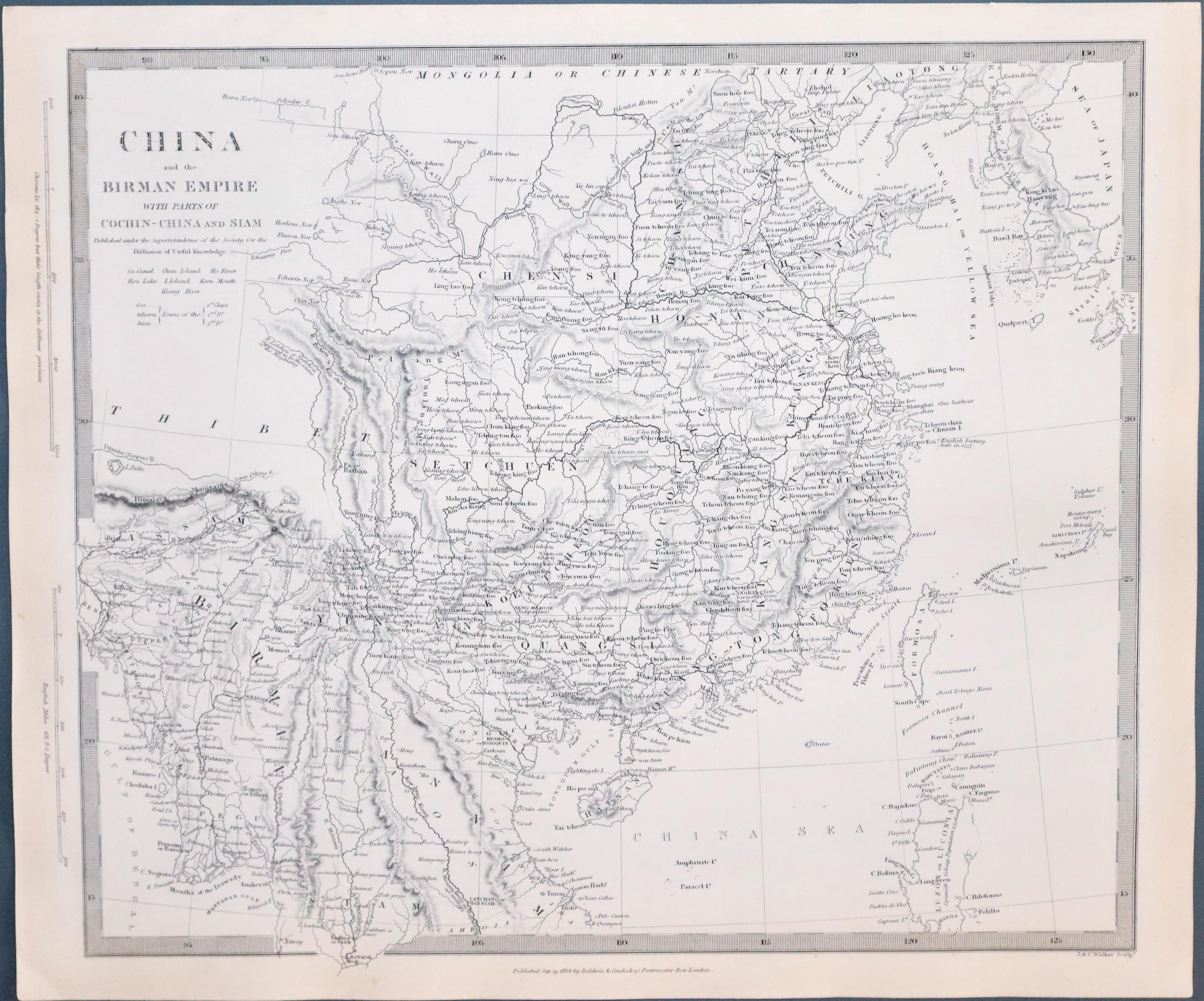
33397 China & the Birman Empire, S.D.U.K. c.1844. Price: 80.00
CHINA AND THE BIRMAN EMPIRE WITH PARTS OF COCHIN-CHINA AND SIAM
A detailed engraved map of the countries. Imprint of Baldwin & Craddock below dated 1834. 12 1/2 x 15 1/4 inches. Uncoloured. Plain on verso. Good condition. Straight from the atlas and not offered previously as a single map.
Published by Society for Diffusion of Useful Knowledge
19th Century
-

Map of China by S.D.U.K.
33398 China, S.D.U.K. c.1844. Price: 80.00
CHINA THE INTERIOR CHEFIN FROM DU HALDE AND THE JESUITS 1710 TO 1718
A detailed engraved map of the the whole of China. Imprint of Chapman & Hall below dated 1843. 12 1/4 x 15 1/2 inches. Uncoloured. Plain on verso. Good condition. Straight from the atlas and not offered previously as a single map.
Published by Society for Diffusion of Useful Knowledge
PRINTS - c.1780
A collection of copper engravings that appeared in Universe Displayed published circa 1780. Each print measures about 6 x 3 1/2 inches. Uncoloured. All in good clean undamaged condition unless otherwise dtates.
-

The Lowa or Fishing Bird of China

25470 The Low or Fishing Bird of China. c.1780. Price: 14.00
-

Begging Devotees of Cha & Jugglers mounted on tamed Tigers

25465 Begging Devotees of Cha & Jugglers mounted on tamed Tigers. c.1780. Price: 14.00
-

Chinese Jugglers, who pretend to sell the Wind

25468 Chinese Jugglers, who pretend to sell the Wind. c.1780. Price: 14.00
-

Magicians & Sorcerers of China

25467 Magicians & Sorcerers of China. Price: 14.00
-

A Chinese Triumphal Arch

25479 A Chinese Triumphal Arch. c.1780. Price: 14.00
-

A Curius Chinese Vessel called a Smake Boat

254678 A Curius Chinese Vessel called a Smake Boat. c.1780. Price: 14.00
-

Nankin the Captital City of China

25474 Nankin the Captital City of China. Price: 18.00
-

The Strange Mountains at Sangwanhab in China

25475 The Strange Mountains at Sangwanhab in China c.1780. Price: 10.00
Small rust spot in the left hand side blank margin
-

Chinese Women

25476 Chinese Women. c.1780. Price: 14.00
PRINTS - 18th & 19th CENTURY
Original copper and steel engraved views by various artists

RICHARD NICHOLSON
of CHESTER
Stoneydale
Pepper Street
Christleton
Chester
CH3 7AG
Telephone
01244 336004
International 44 1244 336004

I have been buying and selling antique maps since the early 1960's during which time I had a gallery in Watergate Street, Chester for 30 years. I am now able to offer through my websites a personal service to map and print collectors.